TopoQuest Logo
Do you find TopoQuest useful?
Help keep TopoQuest running and adding new maps/features by donating!
Bitcoin:  19c7KJd3qBynnjoSw5npx9KScwjBe4ifkT
Litecoin:  LXs6TkuXGGXo1vDsWCkWVdjQX94eUKd6ui
Home View Maps Find Maps Find Places Resources & Links


Bunker Hill, Indiana Topographic Map

USGS Map Title: Bunker Hill, IN
USGS Map MRC: 40086F1
DRG (GeoTIFF) Download: o40086f1.tif


Neighboring USGS Topographic Map Quads:


  Twelve Mile, IN  
40086G2
 

  Peru, IN  
40086G1
 

  Richvalley, IN  
40085G8
 

  Onward, IN  
40086F2
 

  Bunker Hill, IN  
40086F1
 

  Peoria, IN  
40085F8
 

  Galveston, IN  
40086E2
 

  Miami, IN  
40086E1
 

  Amboy, IN  
40085E8


Map MRC Location:

N41°
W87°
N41°
W86°
H8 H7 H6 H5 H4 H3 H2 H1
G8 G7 G6 G5 G4 G3 G2 G1
F8 F7 F6 F5 F4 F3 F2 F1
E8 E7 E6 E5 E4 E3 E2 E1
D8 D7 D6 D5 D4 D3 D2 D1
C8 C7 C6 C5 C4 C3 C2 C1
B8 B7 B6 B5 B4 B3 B2 B1
A8 A7 A6 A5 A4 A3 A2 A1
N40°
W87°
N40°
W86°

Bunker Hill, IN USGS 1:24K Topographic Map Preview:
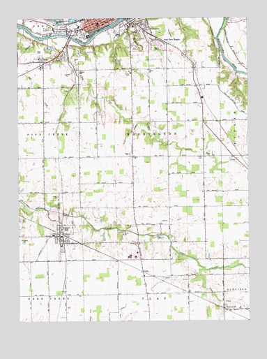
Bunker Hill, IN USGS Topographic Map
Click on map above to begin viewing in our Map Viewer.

This topographic map contains these locations and features:
Feature Name Type Latitude Longitude GNIS ID View Map
Bunker HillPopulated PlaceN40.6603°W86.1028°449627View Map
Bunker Hill Elementary SchoolSchoolN40.6612°W86.1064°447361View Map
Crider CemeteryCemeteryN40.6925°W86.0250°433129View Map
Emmanuel ChurchChurchN40.6573°W86.0611°434177View Map
FloraPopulated PlaceN40.7339°W86.1000°434610View Map
Goodenough AirportAirportN40.7456°W86.0092°2676990View Map
Graff DitchCanalN40.6420°W86.0417°435274View Map
Holman Elementary SchoolSchoolN40.7478°W86.0814°436335View Map
Leonda CemeteryCemeteryN40.6764°W86.1036°437785View Map
Lesher DitchCanalN40.6659°W86.0422°437788View Map
Liberty SchoolSchoolN40.7289°W86.0533°437846View Map
Little Pipe CreekStreamN40.7425°W86.1069°438119View Map
LoreePopulated PlaceN40.6456°W86.0580°438308View Map
Maconaquah Elementary SchoolSchoolN40.6534°W86.0611°447360View Map
Maconaquah High SchoolSchoolN40.6517°W86.0653°447358View Map
Maconaquah Middle SchoolSchoolN40.6517°W86.0619°447359View Map
Maconaquah ParkParkN40.7389°W86.0594°438462View Map
McGrawsvillePopulated PlaceN40.6303°W86.0139°438876View Map
Miami County Emergency Management AgencyBuildingN40.7490°W86.0563°2719345View Map
Midway ChurchChurchN40.7300°W86.1125°439129View Map
Miller Strip Airport (historical)AirportN40.6283°W86.0333°2676873View Map
Nead Elementary SchoolSchoolN40.7473°W86.0619°447357View Map
Negro CreekStreamN40.6470°W86.0253°440174View Map
OakleyPopulated PlaceN40.7020°W86.0125°452094View Map
Park View HeightsPopulated PlaceN40.7414°W86.0497°440881View Map
Peru Fire Department Station 1BuildingN40.7497°W86.0696°2625527View Map
Pipe Creek Township Volunteer Fire DepartmentBuildingN40.6606°W86.1074°2626324View Map
Rankin CemeteryCemeteryN40.6644°W86.0629°441767View Map
Robison AirportAirportN40.7332°W86.1137°449305View Map
Salem CemeteryCemeteryN40.6939°W86.0646°442891View Map
Salem ChurchChurchN40.6925°W86.0625°442921View Map
Salem DitchCanalN40.6964°W86.0667°442928View Map
Schoolman DitchCanalN40.7395°W86.0422°443107View Map
Sharpee CemeteryCemeteryN40.7275°W86.0919°443311View Map
Shinn Bone Lane Airport (historical)AirportN40.6542°W86.0228°449307View Map
South PeruPopulated PlaceN40.7456°W86.0569°443838View Map
Springdale CemeteryCemeteryN40.6599°W86.1220°444004View Map
Town of Bunker HillCivilN40.6599°W86.1011°2396616View Map
Township of WashingtonCivilN40.7016°W86.0517°454006View Map
WellsPopulated PlaceN40.7323°W86.1111°445663View Map
West City ParkParkN40.7423°W86.0908°445729View Map

Note: Coordinates in the location and feature list above are referenced to NAD83 datum.


Copyright (C) 2008-2025 Ryan Niemi / Sunset Dynamics ... All Rights Reserved