TopoQuest Logo
Do you find TopoQuest useful?
Help keep TopoQuest running and adding new maps/features by donating!
Bitcoin:  19c7KJd3qBynnjoSw5npx9KScwjBe4ifkT
Litecoin:  LXs6TkuXGGXo1vDsWCkWVdjQX94eUKd6ui
Home View Maps Find Maps Find Places Resources & Links


Coburn, Pennsylvania Topographic Map

USGS Map Title: Coburn, PA
USGS Map MRC: 40077G4
DRG (GeoTIFF) Download: o40077g4.tif


Neighboring USGS Topographic Map Quads:


  Madisonburg, PA  
40077H5
 

  Millheim, PA  
40077H4
 

  Woodward, PA  
40077H3
 

  Spring Mills, PA  
40077G5
 

  Coburn, PA  
40077G4
 

  Weikert, PA  
40077G3
 

  Burnham, PA  
40077F5
 

  Alfarata, PA  
40077F4
 

  McClure, PA  
40077F3


Map MRC Location:

N41°
W78°
N41°
W77°
H8 H7 H6 H5 H4 H3 H2 H1
G8 G7 G6 G5 G4 G3 G2 G1
F8 F7 F6 F5 F4 F3 F2 F1
E8 E7 E6 E5 E4 E3 E2 E1
D8 D7 D6 D5 D4 D3 D2 D1
C8 C7 C6 C5 C4 C3 C2 C1
B8 B7 B6 B5 B4 B3 B2 B1
A8 A7 A6 A5 A4 A3 A2 A1
N40°
W78°
N40°
W77°

Coburn, PA USGS 1:24K Topographic Map Preview:
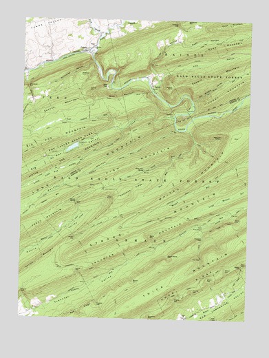
Coburn, PA USGS Topographic Map
Click on map above to begin viewing in our Map Viewer.

This topographic map contains these locations and features:
Feature Name Type Latitude Longitude GNIS ID View Map
Bear GapGapN40.7756°W77.3994°1168872View Map
Bear Gap Picnic AreaAreaN40.7962°W77.3997°1212873View Map
Bear Gap TrailTrailN40.7701°W77.3997°1168876View Map
Big Poe CreekStreamN40.8348°W77.4158°1169546View Map
Big Poe ValleyValleyN40.8332°W77.4269°1169548View Map
Black GapGapN40.7845°W77.4280°1169704View Map
Board Shanty GapGapN40.7756°W77.4180°1169920View Map
Brock GapGapN40.7656°W77.3950°1170305View Map
CCC CampLocaleN40.7609°W77.3855°1197219View Map
Chestnut GapGapN40.7842°W77.3989°1171707View Map
CoburnPopulated PlaceN40.8631°W77.4644°1172103View Map
Coburn Census Designated PlaceCensusN40.8653°W77.4633°2389339View Map
Coburn Post OfficePost OfficeN40.8631°W77.4606°2779948View Map
Dean GapGapN40.7731°W77.3778°1173031View Map
Dean TrailTrailN40.7845°W77.3780°1192335View Map
Dry Hollow TrailTrailN40.8303°W77.4330°1173519View Map
Elk CreekStreamN40.8681°W77.4555°1174108View Map
Elk GapGapN40.8565°W77.4292°1174111View Map
Green GapGapN40.7912°W77.3814°1176061View Map
Greenbrier GapGapN40.8467°W77.4969°1176134View Map
Havice GapGapN40.7692°W77.4669°1176662View Map
Havice MountainSummitN40.7740°W77.4894°1192590View Map
Havice SpringSpringN40.7992°W77.4697°1176663View Map
High MountainSummitN40.8065°W77.4655°1177010View Map
High ValleyValleyN40.8579°W77.4295°1177017View Map
Hutt TrailTrailN40.7787°W77.4433°1177661View Map
InglebyPopulated PlaceN40.8473°W77.4275°1177810View Map
InglebyLocaleN40.8445°W77.4347°1207015View Map
Kerstetter PathTrailN40.8367°W77.4619°1178414View Map
Knob RidgeRidgeN40.7651°W77.4022°1178610View Map
Korman GapGapN40.8734°W77.4144°1178652View Map
Lick HollowValleyN40.8509°W77.4244°1179287View Map
Little Poe CreekStreamN40.8278°W77.4447°1192817View Map
Little Poe MountainSummitN40.8148°W77.4775°1179644View Map
Little Poe TrailTrailN40.8137°W77.4761°1179645View Map
Little Poe ValleyValleyN40.8286°W77.4457°1179646View Map
Loggers PathTrailN40.8192°W77.4903°1179830View Map
McNitt GapGapN40.7845°W77.4697°1180797View Map
McNitt TrailTrailN40.7792°W77.4642°1180798View Map
Mitchell GapGapN40.7615°W77.4047°1181372View Map
Old Mingle ValleyValleyN40.8412°W77.4056°1182927View Map
Panther HollowValleyN40.8289°W77.4156°1183254View Map
Panther Hollow TrailTrailN40.8223°W77.4317°1183257View Map
Panther RunStreamN40.8298°W77.4144°1183265View Map
Penn ViewPopulated PlaceN40.8465°W77.4525°1183500View Map
Penns ViewLocaleN40.8428°W77.4530°1207014View Map
Peters TrailTrailN40.7545°W77.4458°1183633View Map
Pine CreekStreamN40.8609°W77.4611°1193125View Map
Pine Swamp RunStreamN40.8301°W77.4444°1183917View Map
Pitchpine RidgeRidgeN40.8017°W77.4417°1183973View Map
Poe DamDamN40.8234°W77.4680°1195069View Map
Poe LakeReservoirN40.8215°W77.4719°1195068View Map
Poe Mills (historical)Populated PlaceN40.8348°W77.4176°2352263View Map
Poe Paddy State ParkParkN40.8335°W77.4180°1196531View Map
Poe Valley State ParkParkN40.8223°W77.4722°1184166View Map
Price GapGapN40.7976°W77.4692°1184407View Map
Price KettleSlopeN40.8003°W77.4512°1184408View Map
Ravens KnobSummitN40.8373°W77.4236°1207016View Map
Red Ridge TrailTrailN40.7653°W77.4314°1217369View Map
Rock RunStreamN40.8170°W77.4169°1185279View Map
Rupp HollowValleyN40.8663°W77.4146°1185626View Map
Saint Johns ChurchChurchN40.8628°W77.4603°1186145View Map
Sawmill KnobSummitN40.8473°W77.4169°1187024View Map
Sawmill MountainSummitN40.8492°W77.4044°1187025View Map
Second MountainSummitN40.8392°W77.4755°1193313View Map
Showalter GapGapN40.7506°W77.4286°1193355View Map
Skinall GapGapN40.7656°W77.4372°1187754View Map
Slide MountainSummitN40.8437°W77.4405°1187811View Map
Spruce MountainSummitN40.7967°W77.4878°1188336View Map
Stillhouse HollowValleyN40.8571°W77.4613°1188673View Map
Stillhouse KnobSummitN40.8520°W77.4680°1188675View Map
Strong MountainSummitN40.7806°W77.4586°1188887View Map
Swift RunStreamN40.8298°W77.4089°1189181View Map
Tower TrailTrailN40.8198°W77.4955°1189685View Map
Township of ArmaghCivilN40.7566°W77.4882°1216825View Map
Township of PennCivilN40.8568°W77.4911°1216134View Map
Treaster GapGapN40.7562°W77.4569°1189734View Map
Treaster MountainSummitN40.7828°W77.4328°1189736View Map
Trinity ChurchChurchN40.8640°W77.4605°1189798View Map
Tunnel MountainSummitN40.8459°W77.4633°1189927View Map
Wagner GapGapN40.7576°W77.4139°1190469View Map
Wagner GapGapN40.7606°W77.4986°1190470View Map
Weaver GapGapN40.7698°W77.3864°1190738View Map
Wert School (historical)SchoolN40.7576°W77.3897°1197220View Map
White MountainSummitN40.8265°W77.3828°1191290View Map
White Mountain KettleBasinN40.8256°W77.3936°1191291View Map
White Mountain Ridge TrailTrailN40.8201°W77.3964°1191292View Map
White Pine SpringSpringN40.8117°W77.4325°1191310View Map

Note: Coordinates in the location and feature list above are referenced to NAD83 datum.


Copyright (C) 2008-2024 Ryan Niemi / Sunset Dynamics ... All Rights Reserved