TopoQuest Logo
Do you find TopoQuest useful?
Help keep TopoQuest running and adding new maps/features by donating!
Bitcoin:  19c7KJd3qBynnjoSw5npx9KScwjBe4ifkT
Litecoin:  LXs6TkuXGGXo1vDsWCkWVdjQX94eUKd6ui
Home View Maps Find Maps Find Places Resources & Links


Burrows Lake, Wisconsin Topographic Map

USGS Map Title: Burrows Lake, WI
USGS Map MRC: 45089F7
DRG (GeoTIFF) Download: o45089f7.tif


Neighboring USGS Topographic Map Quads:


  Lac du Flambeau SW, WI  
45089G8
 

  Mercer Lake, WI  
45089G7
 

  Hazelhurst, WI  
45089G6
 

  Pier Lake, WI  
45089F8
 

  Burrows Lake, WI  
45089F7
 

  Harshaw, WI  
45089F6
 

  Tripoli, WI  
45089E8
 

  Bradley, WI  
45089E7
 

  Heafford Junction, WI  
45089E6


Map MRC Location:

N46°
W90°
N46°
W89°
H8 H7 H6 H5 H4 H3 H2 H1
G8 G7 G6 G5 G4 G3 G2 G1
F8 F7 F6 F5 F4 F3 F2 F1
E8 E7 E6 E5 E4 E3 E2 E1
D8 D7 D6 D5 D4 D3 D2 D1
C8 C7 C6 C5 C4 C3 C2 C1
B8 B7 B6 B5 B4 B3 B2 B1
A8 A7 A6 A5 A4 A3 A2 A1
N45°
W90°
N45°
W89°

Burrows Lake, WI USGS 1:24K Topographic Map Preview:
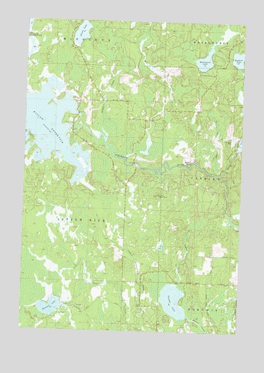
Burrows Lake, WI USGS Topographic Map
Click on map above to begin viewing in our Map Viewer.

This topographic map contains these locations and features:
Feature Name Type Latitude Longitude GNIS ID View Map
Bear CreekStreamN45.6947°W89.8176°1561364View Map
Burrows LakeLakeN45.6343°W89.8582°1562454View Map
Collette School (historical)SchoolN45.6452°W89.7601°1843837View Map
Halfbreed RapidsRapidsN45.6933°W89.7779°1565975View Map
Hughitt LakeLakeN45.7355°W89.7534°1566790View Map
Jack Pine Lookout TowerSummitN45.6800°W89.7982°1567058View Map
Little Rice Volunteer Fire DepartmentBuildingN45.6446°W89.8117°2696943View Map
McCormick LakeLakeN45.7346°W89.7725°1569186View Map
Oelhafen CreekStreamN45.7038°W89.8288°1570752View Map
Rocky RunStreamN45.6861°W89.7582°1572517View Map
Skunk LakeLakeN45.7450°W89.8439°1574255View Map
Swamp LakeLakeN45.6374°W89.7876°1575150View Map
Swan CreekStreamN45.6883°W89.7626°1575158View Map
Town of Little RiceCivilN45.6439°W89.8583°1583584View Map
Willow Reservoir 327ReservoirN45.7116°W89.8451°1793023View Map
Willow River Reservoir 2WP50 DamDamN45.7125°W89.8449°1793022View Map

Note: Coordinates in the location and feature list above are referenced to NAD83 datum.


Copyright (C) 2008-2025 Ryan Niemi / Sunset Dynamics ... All Rights Reserved