TopoQuest Logo
Do you find TopoQuest useful?
Help keep TopoQuest running and adding new maps/features by donating!
Bitcoin:  19c7KJd3qBynnjoSw5npx9KScwjBe4ifkT
Litecoin:  LXs6TkuXGGXo1vDsWCkWVdjQX94eUKd6ui
Home View Maps Find Maps Find Places Resources & Links


Caborn, Indiana Topographic Map

USGS Map Title: Caborn, IN
USGS Map MRC: 37087H7
DRG (GeoTIFF) Download: o37087h7.tif


Neighboring USGS Topographic Map Quads:


  Solitude, IN  
38087A8
 

  Wadesville, IN  
38087A7
 

  Kasson, IN  
38087A6
 

  Mount Vernon, IN  
37087H8
 

  Caborn, IN  
37087H7
 

  West Franklin, IN  
37087H6
 

  Uniontown, KY  
37087G8
 

  Smith Mills, KY  
37087G7
 

  Wilson, KY  
37087G6


Map MRC Location:

N38°
W88°
N38°
W87°
H8 H7 H6 H5 H4 H3 H2 H1
G8 G7 G6 G5 G4 G3 G2 G1
F8 F7 F6 F5 F4 F3 F2 F1
E8 E7 E6 E5 E4 E3 E2 E1
D8 D7 D6 D5 D4 D3 D2 D1
C8 C7 C6 C5 C4 C3 C2 C1
B8 B7 B6 B5 B4 B3 B2 B1
A8 A7 A6 A5 A4 A3 A2 A1
N37°
W88°
N37°
W87°

Caborn, IN USGS 1:24K Topographic Map Preview:
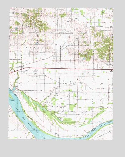
Caborn, IN USGS Topographic Map
Click on map above to begin viewing in our Map Viewer.

This topographic map contains these locations and features:
Feature Name Type Latitude Longitude GNIS ID View Map
Blue Pond (historical)LakeN37.9073°W87.7786°449056View Map
Blue Pond DitchCanalN37.9164°W87.8022°431234View Map
BufkinPopulated PlaceN37.9878°W87.8459°431782View Map
CabornPopulated PlaceN37.9706°W87.7920°449629View Map
Calvin CemeteryCemeteryN37.9570°W87.7961°431994View Map
Castleberry CreekStreamN37.9020°W87.7617°432231View Map
Crunk DitchCanalN37.9012°W87.7945°433227View Map
Cypress SloughStreamN37.9237°W87.8686°433277View Map
Diamond IslandIslandN37.8834°W87.7522°490863View Map
Dixon and Lewis DitchCanalN37.9262°W87.8081°433576View Map
Dixon DitchCanalN37.9184°W87.7761°433582View Map
Goose PondLakeN37.9071°W87.8394°435202View Map
Hartman SchoolSchoolN37.9731°W87.7536°435834View Map
Hickory Branch Post Office (historical)Post OfficeN37.9903°W87.8178°453000View Map
Hilakos AirportAirportN37.9372°W87.7733°2677071View Map
Immanuel ChurchChurchN37.9514°W87.7547°436715View Map
Lewis AirportAirportN37.9153°W87.7618°2676895View Map
Longs Landing Post LightBuildingN37.8834°W87.8334°517043View Map
Marrs CenterPopulated PlaceN37.9456°W87.7550°438645View Map
Marrs Township Volunteer Fire Department Station 2BuildingN37.9469°W87.7547°2626368View Map
Marrs Volunteer Fire DepartmentBuildingN37.9469°W87.7547°2701366View Map
Mount Pleasant ChurchChurchN37.9817°W87.8534°439666View Map
Mount Vernon Towhead IslandIslandN37.9153°W87.8734°498901View Map
Neu CreekStreamN37.9898°W87.7645°440010View Map
Persimmon Pond DitchCanalN37.9073°W87.7961°441040View Map
Saint Johns CemeteryCemeteryN37.9970°W87.8364°442566View Map
Saint Johns ChurchChurchN37.9778°W87.7922°442580View Map
Schieber DitchCanalN37.9167°W87.8147°443070View Map
Southwind Maritime CentreSchoolN37.9245°W87.8667°446883View Map
Stucky SchoolSchoolN37.9278°W87.7820°444289View Map
Thompson SchoolSchoolN37.9648°W87.8653°444723View Map
Township of MarrsCivilN37.9472°W87.7587°453614View Map
Zeller Elevation Company AirportAirportN37.9120°W87.7577°449276View Map

Note: Coordinates in the location and feature list above are referenced to NAD83 datum.


Copyright (C) 2008-2024 Ryan Niemi / Sunset Dynamics ... All Rights Reserved