TopoQuest Logo
Do you find TopoQuest useful?
Help keep TopoQuest running and adding new maps/features by donating!
Bitcoin:  19c7KJd3qBynnjoSw5npx9KScwjBe4ifkT
Litecoin:  LXs6TkuXGGXo1vDsWCkWVdjQX94eUKd6ui
Home View Maps Find Maps Find Places Resources & Links


Mount Vernon, Indiana Topographic Map

USGS Map Title: Mount Vernon, IN
USGS Map MRC: 37087H8
DRG (GeoTIFF) Download: o37087h8.tif


Neighboring USGS Topographic Map Quads:


  Maunie, IL  
38088A1
 

  Solitude, IN  
38087A8
 

  Wadesville, IN  
38087A7
 

  Emma, IL  
37088H1
 

  Mount Vernon, IN  
37087H8
 

  Caborn, IN  
37087H7
 

  Wabash Island, KY  
37088G1
 

  Uniontown, KY  
37087G8
 

  Smith Mills, KY  
37087G7


Map MRC Location:

N38°
W88°
N38°
W87°
H8 H7 H6 H5 H4 H3 H2 H1
G8 G7 G6 G5 G4 G3 G2 G1
F8 F7 F6 F5 F4 F3 F2 F1
E8 E7 E6 E5 E4 E3 E2 E1
D8 D7 D6 D5 D4 D3 D2 D1
C8 C7 C6 C5 C4 C3 C2 C1
B8 B7 B6 B5 B4 B3 B2 B1
A8 A7 A6 A5 A4 A3 A2 A1
N37°
W88°
N37°
W87°

Mount Vernon, IN USGS 1:24K Topographic Map Preview:
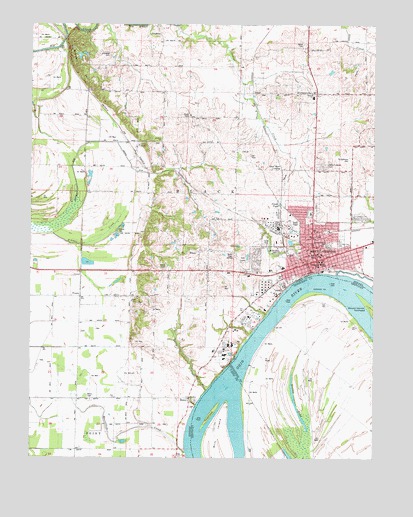
Mount Vernon, IN USGS Topographic Map
Click on map above to begin viewing in our Map Viewer.

This topographic map contains these locations and features:
Feature Name Type Latitude Longitude GNIS ID View Map
Alldredge CemeteryCemeteryN37.9914°W87.9714°430082View Map
Beaverdam CreekStreamN37.8764°W87.9423°430683View Map
Belle Fontaine CemeteryCemeteryN37.9589°W87.8939°430775View Map
Black CemeteryCemeteryN37.9292°W87.9511°431120View Map
Black ChapelChurchN37.9203°W87.9631°431123View Map
Black Township Fire and RescueBuildingN37.9542°W87.8976°2701364View Map
Black Township Fire and Rescue Station 1BuildingN37.9542°W87.8975°2626611View Map
Brewery HillCliffN37.9889°W87.9842°431499View Map
City of Mount VernonCivilN37.9364°W87.8955°2395128View Map
Dead Mans CrossingPopulated PlaceN37.9584°W87.9084°433387View Map
Dunn CemeteryCemeteryN37.9736°W87.9425°433792View Map
ErwinPopulated PlaceN37.9800°W87.9192°434235View Map
FarmersvillePopulated PlaceN37.9803°W87.8961°434406View Map
General Electric Plastics Emergency Response TeamBuildingN37.9152°W87.9224°2626599View Map
Gill CemeteryCemeteryN37.9620°W87.9197°435072View Map
Grassy PondLakeN37.8911°W87.9036°493167View Map
Grassy SloughGutN37.8778°W87.9998°435354View Map
Hedges Central Elementary SchoolSchoolN37.9366°W87.8921°435977View Map
HoveyPopulated PlaceN37.8923°W87.9420°436531View Map
Indian CreekStreamN37.9992°W87.9473°436732View Map
James Whitcomb Riley SchoolSchoolN37.9289°W87.9067°436928View Map
Jeffries SchoolSchoolN37.9223°W87.9489°436983View Map
Lawrence SchoolSchoolN37.8770°W87.9592°437672View Map
McFadden CreekStreamN37.9281°W87.8878°438860View Map
Moore CemeteryCemeteryN37.9948°W87.9006°439390View Map
Mount VernonPopulated PlaceN37.9323°W87.8950°439718View Map
Mount Vernon Fire DepartmentBuildingN37.9340°W87.8959°2625923View Map
Mount Vernon Municipal Airport (historical)AirportN37.9334°W87.8750°449274View Map
Mount Vernon Police DepartmentBuildingN37.9339°W87.8960°2758466View Map
Parrish AirportAirportN37.9935°W87.9452°449275View Map
Pfister PondLakeN37.9481°W87.9095°441073View Map
Pitcher CreekStreamN37.9395°W87.9920°441202View Map
Posey County Emergency Medical ServicesBuildingN37.9307°W87.8980°2719354View Map
Posey County Emergency Services FacilityBuildingN37.9307°W87.8980°2758425View Map
Posey County Jail and Sheriff's OfficeBuildingN37.9367°W87.9104°2758057View Map
PrairiePopulated PlaceN37.9214°W87.9820°441532View Map
Saint Matthews CemeteryCemeteryN37.9614°W87.8836°442723View Map
Smith CreekStreamN37.8945°W87.9356°443674View Map
Towhead IslandIslandN37.8887°W87.9331°505375View Map
Township of BlackCivilN37.9531°W87.9225°453112View Map
UptonPopulated PlaceN37.9645°W87.9617°445176View Map
Weiss CemeteryCemeteryN37.8923°W87.9778°445650View Map
Welborn ChurchChurchN37.9662°W87.9525°445654View Map
West Central Elementary SchoolSchoolN37.9298°W87.9075°445809View Map
Whipple DitchCanalN37.9653°W87.9800°445903View Map
WPCO-AM (Mount Vernon)TowerN37.9342°W87.9284°448478View Map
Zoar ChurchChurchN37.8923°W87.9692°446489View Map

Note: Coordinates in the location and feature list above are referenced to NAD83 datum.


Copyright (C) 2008-2024 Ryan Niemi / Sunset Dynamics ... All Rights Reserved