TopoQuest Logo
Do you find TopoQuest useful?
Help keep TopoQuest running and adding new maps/features by donating!
Bitcoin:  19c7KJd3qBynnjoSw5npx9KScwjBe4ifkT
Litecoin:  LXs6TkuXGGXo1vDsWCkWVdjQX94eUKd6ui
Home View Maps Find Maps Find Places Resources & Links


Uniontown, Kentucky Topographic Map

USGS Map Title: Uniontown, KY
USGS Map MRC: 37087G8
DRG (GeoTIFF) Download: o37087g8.tif


Neighboring USGS Topographic Map Quads:


  Emma, IL  
37088H1
 

  Mount Vernon, IN  
37087H8
 

  Caborn, IN  
37087H7
 

  Wabash Island, KY  
37088G1
 

  Uniontown, KY  
37087G8
 

  Smith Mills, KY  
37087G7
 

  Grove Center, KY  
37088F1
 

  Morganfield, KY  
37087F8
 

  Waverly, KY  
37087F7


Map MRC Location:

N38°
W88°
N38°
W87°
H8 H7 H6 H5 H4 H3 H2 H1
G8 G7 G6 G5 G4 G3 G2 G1
F8 F7 F6 F5 F4 F3 F2 F1
E8 E7 E6 E5 E4 E3 E2 E1
D8 D7 D6 D5 D4 D3 D2 D1
C8 C7 C6 C5 C4 C3 C2 C1
B8 B7 B6 B5 B4 B3 B2 B1
A8 A7 A6 A5 A4 A3 A2 A1
N37°
W88°
N37°
W87°

Uniontown, KY USGS 1:24K Topographic Map Preview:
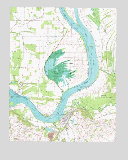
Uniontown, KY USGS Topographic Map
Click on map above to begin viewing in our Map Viewer.

This topographic map contains these locations and features:
Feature Name Type Latitude Longitude GNIS ID View Map
Bayou DrainStreamN37.7992°W87.9306°430596View Map
BoxtownPopulated PlaceN37.7800°W87.9258°2743568View Map
Camp Breckinridge Pumping StationLocaleN37.7987°W87.9159°517106View Map
City of UniontownCivilN37.7732°W87.9318°2405630View Map
Clements BranchStreamN37.7517°W87.9428°489656View Map
Congress GreenSwampN37.8194°W87.9448°432876View Map
Dam Number 49DamN37.7874°W87.9912°517128View Map
Dry ForkStreamN37.7800°W87.9103°491195View Map
Dry LakeLakeN37.8163°W87.9444°433725View Map
Farmers ChapelChurchN37.8189°W87.9811°434399View Map
Fish SloughLakeN37.8125°W87.9264°450914View Map
Grassy SloughGutN37.8739°W87.9986°435353View Map
Highland CreekStreamN37.7820°W87.9345°494210View Map
Hovey LakeLakeN37.8186°W87.9442°436394View Map
Hovey Lake Fish and Wildlife AreaParkN37.8167°W87.9334°446760View Map
John T. Myers Lock and DamDamN37.7928°W87.9914°2743605View Map
Little Pitcher LakeLakeN37.8031°W87.9940°438121View Map
Lost CreekStreamN37.7684°W87.9492°497179View Map
Mississippi BendBendN37.8070°W87.8986°498438View Map
Piroque SloughGutN37.8248°W87.9353°441187View Map
Point Township Volunteer Fire DepartmentBuildingN37.8605°W87.9788°2626350View Map
Powells LakeLakeN37.8557°W87.8962°501251View Map
Rattle SloughLakeN37.8349°W87.8855°501588View Map
Saint Agnes CemeteryCemeteryN37.7625°W87.9295°502560View Map
Slim IslandIslandN37.8737°W87.9289°503692View Map
Towhead IslandIslandN37.8387°W87.9036°505374View Map
Township of PointCivilN37.8421°W87.9931°453753View Map
Union County Volunteer Fire DepartmentBuildingN37.7708°W87.9387°2637056View Map
UniontownPopulated PlaceN37.7753°W87.9306°505827View Map
Uniontown CemeteryCemeteryN37.7756°W87.9195°505828View Map
Uniontown DivisionCivilN37.7813°W87.9229°1937298View Map
Uniontown Fire DepartmentBuildingN37.7721°W87.9353°2637053View Map
Uniontown Police DepartmentBuildingN37.7721°W87.9353°2767594View Map

Note: Coordinates in the location and feature list above are referenced to NAD83 datum.


Copyright (C) 2008-2024 Ryan Niemi / Sunset Dynamics ... All Rights Reserved