TopoQuest Logo
Do you find TopoQuest useful?
Help keep TopoQuest running and adding new maps/features by donating!
Bitcoin:  19c7KJd3qBynnjoSw5npx9KScwjBe4ifkT
Litecoin:  LXs6TkuXGGXo1vDsWCkWVdjQX94eUKd6ui
Home View Maps Find Maps Find Places Resources & Links


Sharon, Georgia Topographic Map

USGS Map Title: Sharon, GA
USGS Map MRC: 33082E7
DRG (GeoTIFF) Download: o33082e7.tif


Neighboring USGS Topographic Map Quads:


  Philomath, GA  
33082F8
 

  Washington West, GA  
33082F7
 

  Washington East, GA  
33082F6
 

  Crawfordville, GA  
33082E8
 

  Sharon, GA  
33082E7
 

  Cadley, GA  
33082E6
 

  Sparta NW, GA  
33082D8
 

  Sparta NE, GA  
33082D7
 

  Warrenton, GA  
33082D6


Map MRC Location:

N34°
W83°
N34°
W82°
H8 H7 H6 H5 H4 H3 H2 H1
G8 G7 G6 G5 G4 G3 G2 G1
F8 F7 F6 F5 F4 F3 F2 F1
E8 E7 E6 E5 E4 E3 E2 E1
D8 D7 D6 D5 D4 D3 D2 D1
C8 C7 C6 C5 C4 C3 C2 C1
B8 B7 B6 B5 B4 B3 B2 B1
A8 A7 A6 A5 A4 A3 A2 A1
N33°
W83°
N33°
W82°

Sharon, GA USGS 1:24K Topographic Map Preview:
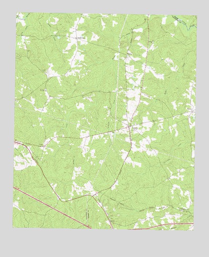
Sharon, GA USGS Topographic Map
Click on map above to begin viewing in our Map Viewer.

This topographic map contains these locations and features:
Feature Name Type Latitude Longitude GNIS ID View Map
BarnettPopulated PlaceN33.5040°W82.8076°354464View Map
Barnett CemeteryCemeteryN33.5064°W82.8072°347667View Map
Barnett CemeteryCemeteryN33.5062°W82.8074°347668View Map
Barnett ChurchChurchN33.5065°W82.8074°347669View Map
Battle - Greeson CemeteryCemeteryN33.5249°W82.8479°347607View Map
Chapman - Rhodes CemeteryCemeteryN33.5071°W82.8674°347610View Map
City of SharonCivilN33.5601°W82.7950°2405449View Map
Daniel B Pilcher CemeteryCemeteryN33.5162°W82.7518°347619View Map
Delila Greeson Meadows CemeteryCemeteryN33.5249°W82.8051°347620View Map
Greater Level Hill CemeteryCemeteryN33.5804°W82.8535°347625View Map
Harris - McGinty CemeteryCemeteryN33.5062°W82.7842°347707View Map
HillmanPopulated PlaceN33.6010°W82.7976°331988View Map
Jennings CemeteryCemeteryN33.5476°W82.8554°347627View Map
Jennings ChurchChurchN33.5476°W82.8551°316077View Map
Kendrick CreekStreamN33.5971°W82.8079°351631View Map
King CemeteryCemeteryN33.5600°W82.8549°347628View Map
Level Hill ChurchChurchN33.5801°W82.8543°316774View Map
Lick CreekStreamN33.6226°W82.8679°316847View Map
Locust Grove CemeteryCemeteryN33.5412°W82.7749°347630View Map
Mill Hill CemeteryCemeteryN33.5668°W82.8076°347632View Map
Mount Olive CemeteryCemeteryN33.6093°W82.7804°347634View Map
Mount Olive ChurchChurchN33.6090°W82.7801°318781View Map
Overton CemeteryCemeteryN33.5643°W82.7946°347636View Map
Pittman CemeteryCemeteryN33.5873°W82.7876°347637View Map
RaytownPopulated PlaceN33.5693°W82.7524°326482View Map
Raytown Baptist ChurchChurchN33.5690°W82.7563°347638View Map
Raytown CemeteryCemeteryN33.5687°W82.7565°347639View Map
Saggus - Lyle CemeteryCemeteryN33.6028°W82.8668°347646View Map
Sallie Sims CemeteryCemeteryN33.5099°W82.7676°347756View Map
Sandy CrossLocaleN33.6104°W82.8326°322478View Map
Sandy Cross Baptist ChurchChurchN33.6157°W82.8329°347642View Map
Sandy Cross CemeteryCemeteryN33.6145°W82.8340°347643View Map
Sandy Cross CemeteryCemeteryN33.6155°W82.8327°347644View Map
Sandy Cross Methodist ChurchChurchN33.6146°W82.8338°347645View Map
SharonPopulated PlaceN33.5599°W82.7949°322779View Map
Sharon CemeteryCemeteryN33.5621°W82.7915°347648View Map
Sharon DivisionCivilN33.5793°W82.7888°1936536View Map
Sharon Methodist ChurchChurchN33.5618°W82.7910°347649View Map
Stephens - Alexander CemeteryCemeteryN33.5772°W82.8647°347651View Map
Stephens CemeteryCemeteryN33.5751°W82.8663°347650View Map
Stewart - Edwards CemeteryCemeteryN33.5777°W82.8323°347652View Map
Sturdivant CemeteryCemeteryN33.5782°W82.8230°347653View Map
Taliaferro Volunteer County Fire Department Station 3BuildingN33.5595°W82.7947°2604422View Map

Note: Coordinates in the location and feature list above are referenced to NAD83 datum.


Copyright (C) 2008-2024 Ryan Niemi / Sunset Dynamics ... All Rights Reserved