TopoQuest Logo
Do you find TopoQuest useful?
Help keep TopoQuest running and adding new maps/features by donating!
Bitcoin:  19c7KJd3qBynnjoSw5npx9KScwjBe4ifkT
Litecoin:  LXs6TkuXGGXo1vDsWCkWVdjQX94eUKd6ui
Home View Maps Find Maps Find Places Resources & Links


Camden North, Alabama Topographic Map

USGS Map Title: Camden North, AL
USGS Map MRC: 32087A3
DRG (GeoTIFF) Download: o32087a3.tif


Neighboring USGS Topographic Map Quads:


  Catherine, AL  
32087B4
 

  Crumptonia, AL  
32087B3
 

  Tasso, AL  
32087B2
 

  Lee Long Bridge, AL  
32087A4
 

  Camden North, AL  
32087A3
 

  Tilden, AL  
32087A2
 

  Coy, AL  
31087H4
 

  Camden South, AL  
31087H3
 

  Rosebud, AL  
31087H2


Map MRC Location:

N33°
W88°
N33°
W87°
H8 H7 H6 H5 H4 H3 H2 H1
G8 G7 G6 G5 G4 G3 G2 G1
F8 F7 F6 F5 F4 F3 F2 F1
E8 E7 E6 E5 E4 E3 E2 E1
D8 D7 D6 D5 D4 D3 D2 D1
C8 C7 C6 C5 C4 C3 C2 C1
B8 B7 B6 B5 B4 B3 B2 B1
A8 A7 A6 A5 A4 A3 A2 A1
N32°
W88°
N32°
W87°

Camden North, AL USGS 1:24K Topographic Map Preview:
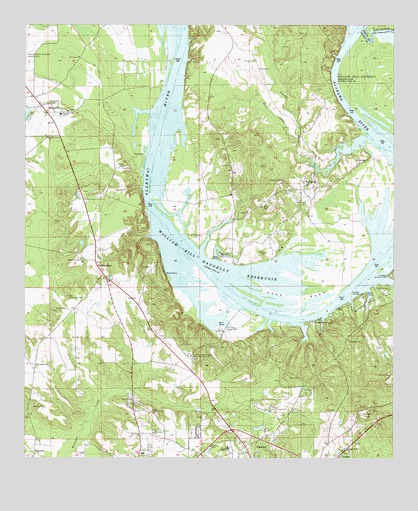
Camden North, AL USGS Topographic Map
Click on map above to begin viewing in our Map Viewer.

This topographic map contains these locations and features:
Feature Name Type Latitude Longitude GNIS ID View Map
Becks CemeteryCemeteryN32.0843°W87.3422°113783View Map
Bell CemeteryCemeteryN32.0232°W87.2825°113853View Map
BoykinPopulated PlaceN32.0779°W87.2814°154993View Map
Boykin Census Designated PlaceCensusN32.0701°W87.2915°2628580View Map
Boykin Elementary SchoolSchoolN32.0796°W87.2797°138439View Map
Bridgeport BeachBeachN32.0502°W87.2564°138440View Map
Bridgeport LandingLocaleN32.0407°W87.2744°156111View Map
Bridgeport Public Use AreaParkN32.0451°W87.2569°114907View Map
Bridges CemeteryCemeteryN32.0338°W87.2650°114908View Map
Camden DivisionCivilN32.0184°W87.2819°165997View Map
Camden State ParkParkN32.0532°W87.2508°115427View Map
Camden Volunteer Fire Department Station 2BuildingN32.0066°W87.2987°2691424View Map
Canton BendLocaleN32.0535°W87.3489°115594View Map
Canton Bend CemeteryCemeteryN32.0563°W87.3503°1729920View Map
Canton Bend SchoolSchoolN32.0063°W87.3711°138447View Map
Canton Bend United Methodist ChurchChurchN32.0565°W87.3505°1729921View Map
City of CamdenCivilN32.0007°W87.2967°2403975View Map
Cochran LandingLocaleN32.0474°W87.2614°156197View Map
Ellis Ferry (historical)CrossingN32.0446°W87.3000°159008View Map
Ellis Ferry Access PointLocaleN32.0379°W87.3092°158825View Map
Foster CreekStreamN32.0932°W87.2583°155070View Map
Friendship ChurchChurchN32.0746°W87.2917°138470View Map
Gees BendBendN32.0468°W87.2811°118883View Map
Gees Bend Access PointLocaleN32.0582°W87.3108°158833View Map
Holy Cross ChurchChurchN32.0068°W87.3353°120307View Map
Hotel CemeteryCemeteryN32.0863°W87.2630°120452View Map
Hurricane IslandIslandN32.0918°W87.2522°138493View Map
Irby CemeteryCemeteryN32.0849°W87.3069°120698View Map
Lower Canton Bar (historical)BarN32.0793°W87.3339°138505View Map
Lower Coastal Plains Experimental FarmLocaleN32.0293°W87.3186°164365View Map
Millers FerryPopulated PlaceN32.0996°W87.3675°122837View Map
New Hope ChurchChurchN32.1160°W87.3572°123813View Map
New Trinity ChurchChurchN32.0074°W87.3311°123911View Map
Old Saint Francis CemeteryCemeteryN32.0460°W87.3605°124241View Map
Pettway CemeteryCemeteryN32.0738°W87.2803°124661View Map
Pigeonfield CemeteryCemeteryN32.0643°W87.3167°124718View Map
Pine Barren CreekStreamN32.1229°W87.2608°155201View Map
Pleasant Grove ChurchChurchN32.0801°W87.2880°152974View Map
Primrose Church Number Two (historical)ChurchN32.0688°W87.2883°138558View Map
Rock West ChurchChurchN32.0013°W87.3711°138566View Map
Saint Francis ChurchChurchN32.0174°W87.3389°126094View Map
Saint Patrick Church (historical)ChurchN32.0468°W87.3550°138575View Map
Saint Wisdom ChurchChurchN32.0271°W87.3708°126223View Map
Sakti HataCliffN32.0446°W87.2503°158394View Map
Sandhill CemeteryCemeteryN32.0729°W87.2933°126354View Map
Shady Grove ChurchChurchN32.0924°W87.3675°126601View Map
Shell CreekStreamN32.0932°W87.2583°126672View Map
Sodom CemeteryCemeteryN32.0593°W87.2939°127095View Map
Ted Loftin DamDamN32.0485°W87.3300°130077View Map
Ted Loftin LakeReservoirN32.0485°W87.3300°130078View Map
Union Grove ChurchChurchN32.0138°W87.3314°128313View Map
Upper Canton Bar (historical)BarN32.0674°W87.3250°138605View Map
Wilcox AcademySchoolN32.0029°W87.3058°128952View Map
Wilcox Central High SchoolSchoolN32.0057°W87.3253°158399View Map
Wilcox Training SchoolSchoolN32.0993°W87.3630°138613View Map
Young CemeteryCemeteryN32.1124°W87.2975°129308View Map
Young CemeteryCemeteryN32.1149°W87.2989°129309View Map
Young Landing (historical)LocaleN32.1229°W87.3197°138622View Map

Note: Coordinates in the location and feature list above are referenced to NAD83 datum.


Copyright (C) 2008-2025 Ryan Niemi / Sunset Dynamics ... All Rights Reserved