TopoQuest Logo
Do you find TopoQuest useful?
Help keep TopoQuest running and adding new maps/features by donating!
Bitcoin:  19c7KJd3qBynnjoSw5npx9KScwjBe4ifkT
Litecoin:  LXs6TkuXGGXo1vDsWCkWVdjQX94eUKd6ui
Home View Maps Find Maps Find Places Resources & Links


Lee Long Bridge, Alabama Topographic Map

USGS Map Title: Lee Long Bridge, AL
USGS Map MRC: 32087A4
DRG (GeoTIFF) Download: o32087a4.tif


Neighboring USGS Topographic Map Quads:


  Flatwood, AL  
32087B5
 

  Catherine, AL  
32087B4
 

  Crumptonia, AL  
32087B3
 

  Kimbrough, AL  
32087A5
 

  Lee Long Bridge, AL  
32087A4
 

  Camden North, AL  
32087A3
 

  Pine Hill, AL  
31087H5
 

  Coy, AL  
31087H4
 

  Camden South, AL  
31087H3


Map MRC Location:

N33°
W88°
N33°
W87°
H8 H7 H6 H5 H4 H3 H2 H1
G8 G7 G6 G5 G4 G3 G2 G1
F8 F7 F6 F5 F4 F3 F2 F1
E8 E7 E6 E5 E4 E3 E2 E1
D8 D7 D6 D5 D4 D3 D2 D1
C8 C7 C6 C5 C4 C3 C2 C1
B8 B7 B6 B5 B4 B3 B2 B1
A8 A7 A6 A5 A4 A3 A2 A1
N32°
W88°
N32°
W87°

Lee Long Bridge, AL USGS 1:24K Topographic Map Preview:
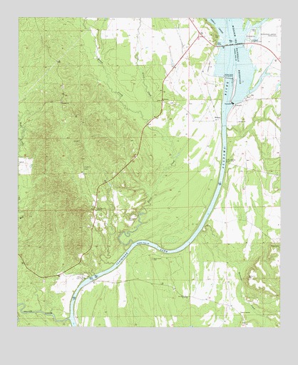
Lee Long Bridge, AL USGS Topographic Map
Click on map above to begin viewing in our Map Viewer.

This topographic map contains these locations and features:
Feature Name Type Latitude Longitude GNIS ID View Map
Antioch ChurchChurchN32.0646°W87.4692°113138View Map
Beaver CreekStreamN32.0035°W87.4750°113725View Map
Bones Hill CemeteryCemeteryN32.0201°W87.3897°114723View Map
Clifton Ferry (historical)CrossingN32.0182°W87.4667°138451View Map
Clifton Ferry Public Use AreaParkN32.0188°W87.4694°116267View Map
Cobbs Landing Access PointLocaleN32.0671°W87.4014°163927View Map
Colonel Evans Landing (historical)LocaleN32.0024°W87.4722°138453View Map
Dixon CreekStreamN32.0340°W87.4458°117316View Map
East Bank Public Use AreaParkN32.1160°W87.3897°117734View Map
Henderson LakeReservoirN32.0968°W87.3900°130134View Map
Henderson Lake DamDamN32.0968°W87.3900°130133View Map
Holy Cross SchoolSchoolN32.0063°W87.3933°120309View Map
Jerusalem ChurchChurchN32.0910°W87.4797°120870View Map
Lee Long BridgeBridgeN32.1143°W87.3981°121475View Map
Little Dixon CreekStreamN32.0832°W87.4397°121777View Map
Little Red CreekStreamN32.0760°W87.4989°121854View Map
Marsh LandingLocaleN32.0432°W87.4106°138517View Map
Matthews LandingLocaleN32.0318°W87.4208°159009View Map
Mendenhall CemeteryCemeteryN32.0435°W87.4480°122654View Map
MidwayPopulated PlaceN32.0843°W87.4050°156707View Map
Midway Landing (historical)LocaleN32.0724°W87.4028°138519View Map
Miller Ferry Bar (historical)BarN32.1218°W87.4003°138521View Map
Millers Ferry (historical)CrossingN32.1215°W87.3986°138522View Map
Millers Ferry Lock and DamDamN32.1007°W87.3989°122838View Map
Millers Ferry MarinaLocaleN32.1215°W87.3861°158390View Map
Millers Ferry Volunteer Fire DepartmentBuildingN32.1204°W87.3840°2691606View Map
New Hope ChurchChurchN32.0124°W87.4203°158884View Map
Pegnee Landing (historical)LocaleN32.0438°W87.4097°138548View Map
Pegues Ferry (historical)CrossingN32.0443°W87.4106°138552View Map
Pine Grove ChurchChurchN32.0479°W87.4625°124784View Map
Pledger CemeteryCemeteryN32.0329°W87.3758°125064View Map
Red CreekStreamN32.0090°W87.4989°125476View Map
Rockwest CreekStreamN32.0396°W87.4131°153195View Map
Saint Michaels ChurchChurchN32.0918°W87.4333°153279View Map
Sand Island CemeteryCemeteryN32.0276°W87.4364°126315View Map
Shell CreekStreamN32.1174°W87.4003°155241View Map
Shell Creek ParkParkN32.1154°W87.4064°138586View Map
Slater BranchStreamN32.1224°W87.4700°126957View Map
South Hall LandingLocaleN32.0460°W87.4108°138593View Map
Tait Landing (historical)LocaleN32.0474°W87.4078°138599View Map
William CreekStreamN32.0257°W87.4539°138615View Map

Note: Coordinates in the location and feature list above are referenced to NAD83 datum.


Copyright (C) 2008-2024 Ryan Niemi / Sunset Dynamics ... All Rights Reserved