TopoQuest Logo
Do you find TopoQuest useful?
Help keep TopoQuest running and adding new maps/features by donating!
Bitcoin:  19c7KJd3qBynnjoSw5npx9KScwjBe4ifkT
Litecoin:  LXs6TkuXGGXo1vDsWCkWVdjQX94eUKd6ui
Home View Maps Find Maps Find Places Resources & Links


Austin, Pennsylvania Topographic Map

USGS Map Title: Austin, PA
USGS Map MRC: 41078F1
DRG (GeoTIFF) Download: o41078f1.tif


Neighboring USGS Topographic Map Quads:


  Roulette, PA  
41078G2
 

  Coudersport, PA  
41078G1
 

  Sweden Valley, PA  
41077G8
 

  Keating Summit, PA  
41078F2
 

  Austin, PA  
41078F1
 

  Ayers Hill, PA  
41077F8
 

  Emporium, PA  
41078E2
 

  Wharton, PA  
41078E1
 

  Conrad, PA  
41077E8


Map MRC Location:

N42°
W79°
N42°
W78°
H8 H7 H6 H5 H4 H3 H2 H1
G8 G7 G6 G5 G4 G3 G2 G1
F8 F7 F6 F5 F4 F3 F2 F1
E8 E7 E6 E5 E4 E3 E2 E1
D8 D7 D6 D5 D4 D3 D2 D1
C8 C7 C6 C5 C4 C3 C2 C1
B8 B7 B6 B5 B4 B3 B2 B1
A8 A7 A6 A5 A4 A3 A2 A1
N41°
W79°
N41°
W78°

Austin, PA USGS 1:24K Topographic Map Preview:
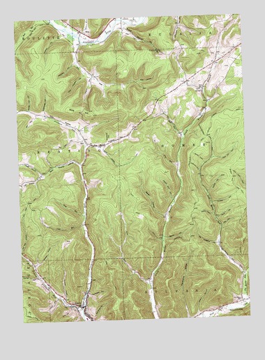
Austin, PA USGS Topographic Map
Click on map above to begin viewing in our Map Viewer.

This topographic map contains these locations and features:
Feature Name Type Latitude Longitude GNIS ID View Map
Aspen TrailTrailN41.6690°W78.0233°1168470View Map
AustinPopulated PlaceN41.6312°W78.0914°1190974View Map
Austin Emergency ServicesBuildingN41.6314°W78.0925°2644994View Map
Austin Post OfficePost OfficeN41.6310°W78.0916°2772582View Map
Baker HollowValleyN41.6680°W78.0446°1168599View Map
Baker RunStreamN41.6681°W78.0433°1212537View Map
Bark Shanty HollowValleyN41.6896°W78.0906°1168711View Map
Barren HollowValleyN41.6586°W78.0450°1168758View Map
Bear HollowValleyN41.7236°W78.0574°1168883View Map
Big Moores RunStreamN41.6312°W78.0003°1169536View Map
Big Tree HollowValleyN41.7001°W78.0912°1169602View Map
Big Younglove HollowValleyN41.6559°W78.0165°1169608View Map
Blue Coat TrailTrailN41.6792°W78.0003°1169870View Map
Borough of AustinCivilN41.6373°W78.0903°1215536View Map
Bridge TrailTrailN41.6917°W78.0250°1198475View Map
Campbell HollowValleyN41.7317°W78.0925°1171127View Map
Cherry HollowValleyN41.7256°W78.0833°1171644View Map
Cochrane HollowValleyN41.6363°W78.0882°1172112View Map
Cody HollowValleyN41.6309°W78.0978°1172125View Map
Coon Chastain HollowValleyN41.7268°W78.0869°1172403View Map
Donovan HollowValleyN41.6338°W78.1009°1173385View Map
Dry HollowValleyN41.6632°W78.0136°1173516View Map
Dry RunStreamN41.6395°W78.0531°1173538View Map
East Branch Freeman RunStreamN41.6973°W78.0858°1173745View Map
Elm FlatFlatN41.7259°W78.0817°1192431View Map
Fork Hill TrailTrailN41.6917°W78.0100°1198758View Map
Gas Well HollowValleyN41.6544°W78.1246°1175475View Map
Gleason HollowValleyN41.7436°W78.0992°1175688View Map
Gravel Lick RunStreamN41.6273°W78.0183°1176004View Map
Harrier HollowValleyN41.6433°W78.1161°1176568View Map
Hemlock TrailTrailN41.6881°W78.0275°1176816View Map
Heth RunStreamN41.6992°W78.0336°1176921View Map
Hill HollowValleyN41.7094°W78.1147°1177078View Map
Homer Post Office (historical)Post OfficeN41.7103°W78.0433°1214321View Map
Horn HollowValleyN41.6347°W78.1055°1177415View Map
InezPopulated PlaceN41.7201°W78.0217°1203872View Map
Inez SchoolSchoolN41.7190°W78.0225°1177808View Map
Jacob RunStreamN41.6687°W78.0886°1177952View Map
Jones RunStreamN41.6648°W78.0895°1178154View Map
Left Branch Bark Shanty HollowValleyN41.6855°W78.1124°1192760View Map
Lehman RunStreamN41.7412°W78.0786°1179166View Map
Little Moores RunStreamN41.6428°W78.0017°1179602View Map
McNamara HollowValleyN41.7467°W78.0341°1180792View Map
MinaPopulated PlaceN41.7440°W78.0864°1204187View Map
Mina HillSummitN41.7120°W78.0950°1181302View Map
Moores Run CemeteryCemeteryN41.6325°W78.0042°1181515View Map
Moores Run Fire TrailTrailN41.6737°W78.0000°1181516View Map
Nestor HollowValleyN41.6266°W78.0278°1182271View Map
OdinPopulated PlaceN41.6978°W78.0864°1204321View Map
Odin HollowValleyN41.6978°W78.0872°1182868View Map
Odin Hoxie TrailTrailN41.6742°W78.0597°1182869View Map
Pine RunStreamN41.6887°W78.0364°1183886View Map
Postalweight HollowValleyN41.7112°W78.1096°1184317View Map
Powder Horn HollowValleyN41.6742°W78.0402°1184357View Map
Pump Station HollowValleyN41.7459°W78.0636°1184489View Map
Ranch-Aero AirportAirportN41.7487°W78.1023°1194277View Map
Ridge TrailTrailN41.6534°W78.0789°1185040View Map
Right Branch Bark Shanty HollowValleyN41.6861°W78.1124°1185068View Map
Rock HollowValleyN41.6663°W78.0164°1185262View Map
Sharps HollowValleyN41.6773°W78.0206°1187381View Map
South HollowValleyN41.6968°W78.0791°1188082View Map
Stuckey HollowValleyN41.6483°W78.1171°1188896View Map
Town RunStreamN41.7440°W78.0895°1189691View Map
Township of HomerCivilN41.6936°W78.0168°1216976View Map
West Branch Freeman RunStreamN41.6281°W78.0917°1190905View Map
White Birch TrailTrailN41.6701°W78.0033°1191250View Map
Windfall HollowValleyN41.6726°W78.0183°1191571View Map
Woodbury HollowValleyN41.6987°W78.0749°1191722View Map
Wooley Lot HollowValleyN41.7128°W78.1175°1191784View Map

Note: Coordinates in the location and feature list above are referenced to NAD83 datum.


Copyright (C) 2008-2024 Ryan Niemi / Sunset Dynamics ... All Rights Reserved