TopoQuest Logo
Do you find TopoQuest useful?
Help keep TopoQuest running and adding new maps/features by donating!
Bitcoin:  19c7KJd3qBynnjoSw5npx9KScwjBe4ifkT
Litecoin:  LXs6TkuXGGXo1vDsWCkWVdjQX94eUKd6ui
Home View Maps Find Maps Find Places Resources & Links


Roulette, Pennsylvania Topographic Map

USGS Map Title: Roulette, PA
USGS Map MRC: 41078G2
DRG (GeoTIFF) Download: o41078g2.tif


Neighboring USGS Topographic Map Quads:


  Bullis Mills, PA  
41078H3
 

  Shinglehouse, PA  
41078H2
 

  Oswayo, PA  
41078H1
 

  Port Allegany, PA  
41078G3
 

  Roulette, PA  
41078G2
 

  Coudersport, PA  
41078G1
 

  Norwich, PA  
41078F3
 

  Keating Summit, PA  
41078F2
 

  Austin, PA  
41078F1


Map MRC Location:

N42°
W79°
N42°
W78°
H8 H7 H6 H5 H4 H3 H2 H1
G8 G7 G6 G5 G4 G3 G2 G1
F8 F7 F6 F5 F4 F3 F2 F1
E8 E7 E6 E5 E4 E3 E2 E1
D8 D7 D6 D5 D4 D3 D2 D1
C8 C7 C6 C5 C4 C3 C2 C1
B8 B7 B6 B5 B4 B3 B2 B1
A8 A7 A6 A5 A4 A3 A2 A1
N41°
W79°
N41°
W78°

Roulette, PA USGS 1:24K Topographic Map Preview:
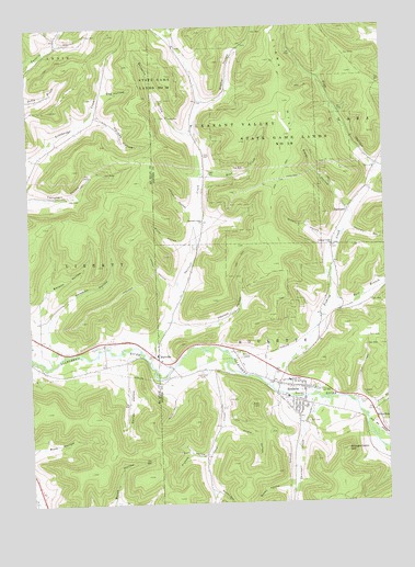
Roulette, PA USGS Topographic Map
Click on map above to begin viewing in our Map Viewer.

This topographic map contains these locations and features:
Feature Name Type Latitude Longitude GNIS ID View Map
Allard HollowValleyN41.7703°W78.1809°1168160View Map
Baker HollowValleyN41.8266°W78.1384°1168600View Map
Baker HollowValleyN41.7534°W78.1866°1168603View Map
Bear CreekStreamN41.8370°W78.1839°1168860View Map
Beckwith HollowValleyN41.8474°W78.1934°1192112View Map
Benson HollowValleyN41.8064°W78.2432°1169271View Map
Brown HollowValleyN41.7542°W78.1597°1170371View Map
Buck RunStreamN41.7612°W78.2253°1202252View Map
Burch HollowValleyN41.7506°W78.2214°1192220View Map
Burt HollowValleyN41.7812°W78.1994°1170759View Map
BurtvillePopulated PlaceN41.7890°W78.2050°1203197View Map
Card CreekStreamN41.7895°W78.1872°1171195View Map
Card Creek CemeteryCemeteryN41.7844°W78.1899°1171196View Map
Card Creek SchoolSchoolN41.7751°W78.1831°1200804View Map
Card Creek SchoolSchoolN41.7773°W78.1836°1206498View Map
Clara HillSummitN41.8662°W78.1653°1171898View Map
Coleman CreekStreamN41.7873°W78.2431°1202134View Map
Coleman HollowValleyN41.7978°W78.2440°1172187View Map
Dexter HollowValleyN41.7852°W78.2190°1173220View Map
DurwardPopulated PlaceN41.8265°W78.1375°1203461View Map
East Branch Fishing CreekStreamN41.8015°W78.1450°1173744View Map
Ernst HollowValleyN41.8179°W78.1942°1174311View Map
Fishing CreekStreamN41.7806°W78.1650°1174842View Map
Fishing Creek ChurchChurchN41.8178°W78.1431°1174843View Map
Fishing Creek School (historical)SchoolN41.8381°W78.1267°1200802View Map
Fisk HollowValleyN41.8378°W78.1278°1174849View Map
Fisk Hollow RunStreamN41.8362°W78.1281°1212753View Map
Gleason HollowValleyN41.8713°W78.2377°1175689View Map
Green HollowValleyN41.8183°W78.1445°1176081View Map
Guy HollowValleyN41.8580°W78.2221°1176330View Map
Hackett HollowValleyN41.8216°W78.1372°1192574View Map
Hanson HollowValleyN41.7969°W78.1991°1176487View Map
Hardes HollowValleyN41.8514°W78.2253°1176505View Map
Hill CemeteryCemeteryN41.7712°W78.1528°1177067View Map
Jordan HollowValleyN41.8069°W78.1991°1178168View Map
KnowltonPopulated PlaceN41.7715°W78.1272°1203957View Map
Laninger CreekStreamN41.7776°W78.1525°1178875View Map
Leman HollowValleyN41.8267°W78.1924°1179184View Map
Lyman CemeteryCemeteryN41.7766°W78.1354°1180102View Map
Meacham HollowValleyN41.8095°W78.1945°1200803View Map
Nichols HollowValleyN41.7623°W78.1892°1182438View Map
Riverside ChurchChurchN41.7778°W78.1545°1185142View Map
RoulettePopulated PlaceN41.7801°W78.1539°1185514View Map
Roulette Census Designated PlaceCensusN41.7768°W78.1551°2630038View Map
Roulette Chemical Engine Company 1BuildingN41.7791°W78.1544°2645485View Map
Roulette Post OfficePost OfficeN41.7802°W78.1549°2772953View Map
Sartwell CreekStreamN41.7878°W78.2075°1186986View Map
Sartwell Creek ChurchChurchN41.8242°W78.1881°1186987View Map
Shingle Cabin HillSummitN41.7637°W78.1392°1187531View Map
Smith SchoolSchoolN41.7820°W78.1592°1187892View Map
State Game Lands Number 59ParkN41.8423°W78.1595°1188518View Map
Township of Pleasant ValleyCivilN41.8653°W78.1769°1216980View Map
Township of RouletteCivilN41.7771°W78.1487°1216982View Map
Trout BrookStreamN41.7726°W78.1320°1209356View Map
Weimer SchoolSchoolN41.8626°W78.1911°1200801View Map
Weimer SchoolSchoolN41.8615°W78.1911°1206499View Map
Wiemer HollowValleyN41.8554°W78.1878°1191377View Map
WillistonPopulated PlaceN41.8365°W78.1900°1212748View Map
WillistonLocaleN41.8367°W78.1900°1212050View Map

Note: Coordinates in the location and feature list above are referenced to NAD83 datum.


Copyright (C) 2008-2025 Ryan Niemi / Sunset Dynamics ... All Rights Reserved