TopoQuest Logo
Do you find TopoQuest useful?
Help keep TopoQuest running and adding new maps/features by donating!
Bitcoin:  19c7KJd3qBynnjoSw5npx9KScwjBe4ifkT
Litecoin:  LXs6TkuXGGXo1vDsWCkWVdjQX94eUKd6ui
Home View Maps Find Maps Find Places Resources & Links


Keating Summit, Pennsylvania Topographic Map

USGS Map Title: Keating Summit, PA
USGS Map MRC: 41078F2
DRG (GeoTIFF) Download: o41078f2.tif


Neighboring USGS Topographic Map Quads:


  Port Allegany, PA  
41078G3
 

  Roulette, PA  
41078G2
 

  Coudersport, PA  
41078G1
 

  Norwich, PA  
41078F3
 

  Keating Summit, PA  
41078F2
 

  Austin, PA  
41078F1
 

  Rich Valley, PA  
41078E3
 

  Emporium, PA  
41078E2
 

  Wharton, PA  
41078E1


Map MRC Location:

N42°
W79°
N42°
W78°
H8 H7 H6 H5 H4 H3 H2 H1
G8 G7 G6 G5 G4 G3 G2 G1
F8 F7 F6 F5 F4 F3 F2 F1
E8 E7 E6 E5 E4 E3 E2 E1
D8 D7 D6 D5 D4 D3 D2 D1
C8 C7 C6 C5 C4 C3 C2 C1
B8 B7 B6 B5 B4 B3 B2 B1
A8 A7 A6 A5 A4 A3 A2 A1
N41°
W79°
N41°
W78°

Keating Summit, PA USGS 1:24K Topographic Map Preview:
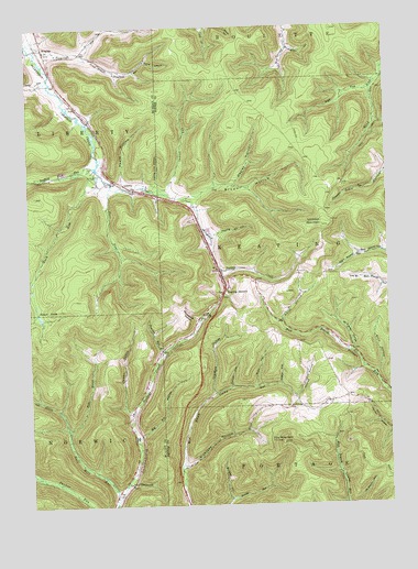
Keating Summit, PA USGS Topographic Map
Click on map above to begin viewing in our Map Viewer.

This topographic map contains these locations and features:
Feature Name Type Latitude Longitude GNIS ID View Map
Andrew HollowValleyN41.6532°W78.1574°1168298View Map
Big Fill HollowValleyN41.6433°W78.2115°1169501View Map
Brown HollowValleyN41.7054°W78.1920°1170369View Map
Brown Hollow Number 1 TrailTrailN41.7123°W78.1686°1205870View Map
Brown Hollow Number 2 TrailTrailN41.7067°W78.1756°1205872View Map
Brown Hollow Number 3 TrailTrailN41.7217°W78.1872°1205871View Map
Buck HollowValleyN41.6592°W78.1292°1170518View Map
Buckbee HollowValleyN41.6265°W78.1810°1170557View Map
Bush HollowValleyN41.6563°W78.1709°1170763View Map
Cady HollowValleyN41.7372°W78.2426°1170865View Map
Camp HollowValleyN41.7413°W78.2080°1171025View Map
Cannon HollowValleyN41.6497°W78.2155°1171163View Map
County Line HollowValleyN41.7094°W78.2047°1172508View Map
Crawford HollowValleyN41.6544°W78.1860°1172651View Map
Culver HollowValleyN41.6559°W78.1799°1172823View Map
Dempsey RunStreamN41.6653°W78.2031°1173147View Map
Fair RunStreamN41.7087°W78.2206°1174413View Map
Fox MountainSummitN41.6412°W78.1620°1175103View Map
Fox Mountain Fire TowerTowerN41.6412°W78.1620°1206711View Map
Half Mile RunStreamN41.6273°W78.2203°1176381View Map
Hamilton RunStreamN41.7462°W78.2489°1176426View Map
Healey HollowValleyN41.7091°W78.1778°1176725View Map
Heath HollowValleyN41.7104°W78.2166°1176731View Map
Indian RunStreamN41.7076°W78.2070°1177778View Map
Keating SummitPopulated PlaceN41.6809°W78.1811°1178271View Map
Left Branch Half Mile RunStreamN41.6503°W78.2403°1179138View Map
LibertyPopulated PlaceN41.7092°W78.2161°1204023View Map
Little Fill HollowValleyN41.6309°W78.2146°1179543View Map
Lookout MountainSummitN41.6981°W78.1470°1179932View Map
Lookout Mountain OverlookSummitN41.6976°W78.1442°1201383View Map
McCurvey HollowValleyN41.6656°W78.1375°1180683View Map
McLaughlin HollowValleyN41.7445°W78.1579°1180773View Map
Mitcheltree HollowValleyN41.6738°W78.1913°1181379View Map
Planing Mill HollowValleyN41.6957°W78.1852°1183994View Map
Portage CreekLocaleN41.7206°W78.2233°1213440View Map
Reese HollowValleyN41.6565°W78.1626°1184845View Map
Right Branch Half Mile RunStreamN41.6453°W78.2364°1185072View Map
Right Fork Reed RunStreamN41.7331°W78.1297°1185077View Map
Rock RunStreamN41.7131°W78.2256°1185284View Map
Scaffold Lick RunStreamN41.7140°W78.2258°1187055View Map
Slabtown HollowValleyN41.6355°W78.1967°1187778View Map
Slide Hollow BranchStreamN41.7053°W78.1953°1212538View Map
Smith HollowValleyN41.6733°W78.1622°1187877View Map
South Branch Hamilton RunStreamN41.7434°W78.2303°1188024View Map
Township of KeatingCivilN41.6935°W78.1365°1216977View Map
Whiting CreekStreamN41.7078°W78.1736°1212752View Map
WrightsPopulated PlaceN41.7448°W78.2436°1204996View Map

Note: Coordinates in the location and feature list above are referenced to NAD83 datum.


Copyright (C) 2008-2025 Ryan Niemi / Sunset Dynamics ... All Rights Reserved