TopoQuest Logo
Do you find TopoQuest useful?
Help keep TopoQuest running and adding new maps/features by donating!
Bitcoin:  19c7KJd3qBynnjoSw5npx9KScwjBe4ifkT
Litecoin:  LXs6TkuXGGXo1vDsWCkWVdjQX94eUKd6ui
Home View Maps Find Maps Find Places Resources & Links


Bear Trap Creek, Montana Topographic Map

USGS Map Title: Bear Trap Creek, MT
USGS Map MRC: 45111E5
DRG (GeoTIFF) Download: o45111e5.tif


Neighboring USGS Topographic Map Quads:


  Willow Creek Reservoir, MT  
45111F6
 

  Norris NE, MT  
45111F5
 

  Madison Plateau, MT  
45111F4
 

  Norris, MT  
45111E6
 

  Bear Trap Creek, MT  
45111E5
 

  Cherry Creek Canyon, MT  
45111E4
 

  Ennis Lake, MT  
45111D6
 

  Cherry Lake, MT  
45111D5
 

  Willow Swamp, MT  
45111D4


Map MRC Location:

N46°
W112°
N46°
W111°
H8 H7 H6 H5 H4 H3 H2 H1
G8 G7 G6 G5 G4 G3 G2 G1
F8 F7 F6 F5 F4 F3 F2 F1
E8 E7 E6 E5 E4 E3 E2 E1
D8 D7 D6 D5 D4 D3 D2 D1
C8 C7 C6 C5 C4 C3 C2 C1
B8 B7 B6 B5 B4 B3 B2 B1
A8 A7 A6 A5 A4 A3 A2 A1
N45°
W112°
N45°
W111°

Bear Trap Creek, MT USGS 1:24K Topographic Map Preview:
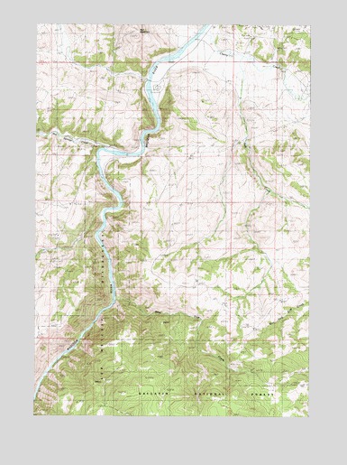
Bear Trap Creek, MT USGS Topographic Map
Click on map above to begin viewing in our Map Viewer.

This topographic map contains these locations and features:
Feature Name Type Latitude Longitude GNIS ID View Map
03S01E02BDC_01 WellWellN45.6060°W111.5711°810465View Map
Bear Trap CreekStreamN45.5366°W111.5894°779565View Map
Bear Trap Creek MineMineN45.5180°W111.5369°804122View Map
Bear Trap Creek Number 2 MineMineN45.5388°W111.5675°804551View Map
Beartrap Recreation AreaLocaleN45.6063°W111.5694°794548View Map
Cherry CreekStreamN45.6227°W111.5497°781189View Map
Cherry Creek School (historical)SchoolN45.6224°W111.5461°781195View Map
Cold Spring CreekStreamN45.6069°W111.5747°1797626View Map
Copper King MineMineN45.5574°W111.6136°804528View Map
Ferry Landing Historic SiteLocaleN45.6088°W111.5769°794552View Map
Hot Springs CreekStreamN45.5849°W111.5950°785088View Map
Lee Metcalf WildernessReserveN45.5166°W111.6078°2035565View Map
Lewis Post Office (historical)Post OfficeN45.6166°W111.5619°1797497View Map
Madison River BridgeBridgeN45.6069°W111.5741°1797679View Map
Moore Ranch Number 1 MineMineN45.6222°W111.5305°804544View Map
Moore Ranch Number 2 MineMineN45.6208°W111.5286°804547View Map
Moore Ranch Number 3 MineMineN45.6249°W111.5300°804561View Map
Morning Star MineMineN45.5491°W111.6175°804538View Map
NE NW Section 21 MineMineN45.5677°W111.6100°804536View Map
NE NW Section 28 MineMineN45.5527°W111.6091°804537View Map
NE SE Section 21 MineMineN45.5577°W111.6030°804520View Map
NW NE Section 15 MineMineN45.5805°W111.5861°804550View Map
Pole CreekStreamN45.6149°W111.5333°789057View Map
Red MountainSummitN45.6210°W111.5802°806803View Map
Savannah Ridge MineMineN45.6097°W111.5014°804549View Map
Stephens RanchLocaleN45.6116°W111.6094°791491View Map

Note: Coordinates in the location and feature list above are referenced to NAD83 datum.


Copyright (C) 2008-2024 Ryan Niemi / Sunset Dynamics ... All Rights Reserved