TopoQuest Logo
Do you find TopoQuest useful?
Help keep TopoQuest running and adding new maps/features by donating!
Bitcoin:  19c7KJd3qBynnjoSw5npx9KScwjBe4ifkT
Litecoin:  LXs6TkuXGGXo1vDsWCkWVdjQX94eUKd6ui
Home View Maps Find Maps Find Places Resources & Links


Cochrane, Wisconsin Topographic Map

USGS Map Title: Cochrane, WI
USGS Map MRC: 44091B7
DRG (GeoTIFF) Download: o44091b7.tif


Neighboring USGS Topographic Map Quads:


  Alma, WI  
44091C8
 

  Cream, WI  
44091C7
 

  Waumandee, WI  
44091C6
 

  Weaver, MN  
44091B8
 

  Cochrane, WI  
44091B7
 

  Fountain City, WI  
44091B6
 

  Altura, MN  
44091A8
 

  Rollingstone, MN  
44091A7
 

  Winona West, MN  
44091A6


Map MRC Location:

N45°
W92°
N45°
W91°
H8 H7 H6 H5 H4 H3 H2 H1
G8 G7 G6 G5 G4 G3 G2 G1
F8 F7 F6 F5 F4 F3 F2 F1
E8 E7 E6 E5 E4 E3 E2 E1
D8 D7 D6 D5 D4 D3 D2 D1
C8 C7 C6 C5 C4 C3 C2 C1
B8 B7 B6 B5 B4 B3 B2 B1
A8 A7 A6 A5 A4 A3 A2 A1
N44°
W92°
N44°
W91°

Cochrane, WI USGS 1:24K Topographic Map Preview:
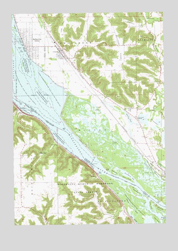
Cochrane, WI USGS Topographic Map
Click on map above to begin viewing in our Map Viewer.

This topographic map contains these locations and features:
Feature Name Type Latitude Longitude GNIS ID View Map
Bass CampLocaleN44.1544°W91.8052°639666View Map
Bensel PondLakeN44.1920°W91.7865°1561570View Map
Bucks IslandIslandN44.2279°W91.8673°2761270View Map
Buffalo CityPopulated PlaceN44.2305°W91.8643°1562364View Map
Buffalo Lutheran SchoolSchoolN44.2229°W91.8320°2715829View Map
Bullrush IslandIslandN44.2013°W91.8439°2729880View Map
Chimney RockPillarN44.1605°W91.8218°641161View Map
City of Buffalo CityCivilN44.2237°W91.8654°1582884View Map
City of MinneiskaCivilN44.1969°W91.8743°2395346View Map
CochranePopulated PlaceN44.2275°W91.8352°1563221View Map
Cochrane - Fountain City Elementary SchoolSchoolN44.1919°W91.7783°2715840View Map
Cochrane - Fountain City High SchoolSchoolN44.1919°W91.7783°1563222View Map
CzechvillePopulated PlaceN44.1872°W91.7735°1577566View Map
Deep Hole IslandIslandN44.2032°W91.8384°2729879View Map
Deer Toe IslandIslandN44.2087°W91.8626°2729883View Map
Deering ValleyValleyN44.1345°W91.7847°642740View Map
Eagle CreekStreamN44.1691°W91.7524°1564238View Map
Garden Valley School (historical)SchoolN44.1961°W91.7635°1837510View Map
Haddock SloughGutN44.1372°W91.7796°644551View Map
Huber RidgeRidgeN44.2452°W91.8299°1566786View Map
Island Number Fifty-fourIslandN44.1519°W91.7818°1567038View Map
Island Number Fifty-threeIslandN44.1555°W91.7921°1567037View Map
Island Number Fifty-twoIslandN44.1564°W91.7957°1567036View Map
Island Number FiftyeightIslandN44.1330°W91.7557°645510View Map
Island Number FiftyfiveIslandN44.1439°W91.7760°645508View Map
Island Number FiftysevenIslandN44.1352°W91.7629°645509View Map
Island Number FortynineIslandN44.1925°W91.8621°645507View Map
Island Number SixtyIslandN44.1275°W91.7574°645511View Map
John Latsch State ParkParkN44.1619°W91.8221°645671View Map
Keller IslandIslandN44.2197°W91.8663°1567378View Map
Kieselhorse BayBayN44.1536°W91.7802°1567467View Map
Lock and Dam 5DamN44.1605°W91.8115°646985View Map
Lock and Dam Number 5DamN44.1616°W91.8118°1776816View Map
Lock and Dam Number 5DamN44.1611°W91.8107°1568478View Map
Middle Island (historical)IslandN44.2005°W91.8510°1837530View Map
MinneiskaPopulated PlaceN44.1950°W91.8718°647927View Map
Mississippi River Historical MarkerParkN44.1597°W91.8127°2052202View Map
Mount Vernon CemeteryCemeteryN44.1661°W91.8688°648189View Map
Oak Valley School (historical)SchoolN44.2180°W91.7524°1837545View Map
Pelican IslandIslandN44.2129°W91.8664°2729885View Map
Pomme de Terre SloughChannelN44.2389°W91.8740°1571746View Map
Pool 5ReservoirN44.1649°W91.8151°1776817View Map
Scenic Valley Emergency Medical ServicesBuildingN44.2278°W91.8354°2698417View Map
Screech Owl CreekStreamN44.2464°W91.7627°1573859View Map
Snipe IslandIslandN44.1942°W91.8410°2729877View Map
Snyder LakeLakeN44.1259°W91.7645°2729869View Map
Spring Lake (historical)LakeN44.1969°W91.8514°1837557View Map
Stirn Island (historical)IslandN44.2452°W91.8746°1837558View Map
Thorpe Wildlife Management AreaParkN44.1491°W91.7927°2729868View Map
Town of MiltonCivilN44.1772°W91.7596°1583721View Map
Tri - Community Fire DepartmentBuildingN44.2302°W91.8515°2697672View Map
Village of CochraneCivilN44.2281°W91.8391°1582994View Map
Water Snake IslandIslandN44.2090°W91.8476°2729884View Map
Waumandee ValleyValleyN44.2446°W91.7577°1576317View Map
WhitmanPopulated PlaceN44.1533°W91.8060°655009View Map
Whitman Bottoms Floodplain Forest State Natural AreaParkN44.1661°W91.7990°2061658View Map
Whitman DikeLeveeN44.1822°W91.8294°2729876View Map

Note: Coordinates in the location and feature list above are referenced to NAD83 datum.


Copyright (C) 2008-2025 Ryan Niemi / Sunset Dynamics ... All Rights Reserved