TopoQuest Logo
Do you find TopoQuest useful?
Help keep TopoQuest running and adding new maps/features by donating!
Bitcoin:  19c7KJd3qBynnjoSw5npx9KScwjBe4ifkT
Litecoin:  LXs6TkuXGGXo1vDsWCkWVdjQX94eUKd6ui
Home View Maps Find Maps Find Places Resources & Links


Alma, Wisconsin Topographic Map

USGS Map Title: Alma, WI
USGS Map MRC: 44091C8
DRG (GeoTIFF) Download: o44091c8.tif


Neighboring USGS Topographic Map Quads:


  Wabasha North, MN  
44092D1
 

  Urne, WI  
44091D8
 

  Modena, WI  
44091D7
 

  Wabasha South, MN  
44092C1
 

  Alma, WI  
44091C8
 

  Cream, WI  
44091C7
 

  Beaver, MN  
44092B1
 

  Weaver, MN  
44091B8
 

  Cochrane, WI  
44091B7


Map MRC Location:

N45°
W92°
N45°
W91°
H8 H7 H6 H5 H4 H3 H2 H1
G8 G7 G6 G5 G4 G3 G2 G1
F8 F7 F6 F5 F4 F3 F2 F1
E8 E7 E6 E5 E4 E3 E2 E1
D8 D7 D6 D5 D4 D3 D2 D1
C8 C7 C6 C5 C4 C3 C2 C1
B8 B7 B6 B5 B4 B3 B2 B1
A8 A7 A6 A5 A4 A3 A2 A1
N44°
W92°
N44°
W91°

Alma, WI USGS 1:24K Topographic Map Preview:
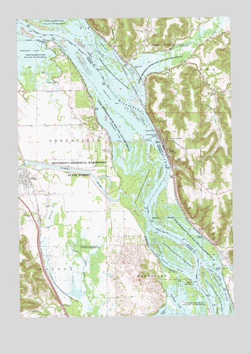
Alma, WI USGS Topographic Map
Click on map above to begin viewing in our Map Viewer.

This topographic map contains these locations and features:
Feature Name Type Latitude Longitude GNIS ID View Map
3.9 ReservoirReservoirN44.3326°W91.8860°1792319View Map
AlmaPopulated PlaceN44.3200°W91.9149°1560795View Map
Alma Elementary SchoolSchoolN44.3632°W91.9433°2715868View Map
Alma Generating StationBuildingN44.3083°W91.9108°2391889View Map
Alma High SchoolSchoolN44.3631°W91.9433°1560796View Map
Alma Mill 1 D6519 DamDamN44.3333°W91.8852°1792318View Map
Alma Municipal Wastewater PlantLocaleN44.3117°W91.9111°2709823View Map
Alma Police DepartmentBuildingN44.3248°W91.9177°2759628View Map
Alma Volunteer Fire DepartmentBuildingN44.3246°W91.9176°2697820View Map
Buena Vista ParkParkN44.3239°W91.9113°1562357View Map
Buffalo County JailBuildingN44.3194°W91.9131°2759833View Map
Buffalo County Sheriff's DepartmentBuildingN44.3198°W91.9133°2759581View Map
Buffalo RiverStreamN44.3505°W91.9263°1562371View Map
Buffalo SloughGutN44.3586°W91.9454°1562373View Map
City of AlmaCivilN44.3365°W91.9223°1582675View Map
City of KelloggCivilN44.3074°W91.9989°2395503View Map
Clear LakeLakeN44.3201°W91.9445°2729908View Map
Fimian CreekStreamN44.3439°W91.8777°1564939View Map
Finger LakesLakeN44.3205°W91.9334°2729903View Map
First Finger LakeLakeN44.3152°W91.9281°2729904View Map
Fisher IslandIslandN44.2511°W91.8907°643706View Map
Gorman CreekStreamN44.2886°W91.9746°644278View Map
Graff TractAreaN44.3005°W91.9443°2729901View Map
Halfmoon LakeLakeN44.2575°W91.9104°644576View Map
Indian PointCapeN44.2697°W91.8815°1566929View Map
Iron CreekStreamN44.3583°W91.9321°1566966View Map
Iron Creek School (historical)SchoolN44.3619°W91.9285°1578542View Map
Island 42IslandN44.2743°W91.9043°2729900View Map
Island 42 Closing StructureDamN44.2831°W91.9156°2729913View Map
John P Madgett Generating StationBuildingN44.3031°W91.9125°2392009View Map
KelloggPopulated PlaceN44.3086°W91.9957°646073View Map
KelloggLocaleN44.3067°W91.9931°2064735View Map
Kellogg Fire DepartmentBuildingN44.3068°W91.9953°2064738View Map
Kellogg ParkParkN44.3069°W91.9972°2064739View Map
Kellogg Post OfficePost OfficeN44.3072°W91.9958°2064736View Map
Kellogg United Methodist ChurchChurchN44.3078°W91.9978°2064737View Map
Kellogg-Weaver Dunes State Natural AreaParkN44.2621°W91.9209°2729895View Map
Krueger SloughGutN44.2515°W91.8944°2761289View Map
KWMB-AM (Wabasha)TowerN44.3455°W91.9746°663265View Map
Lock and Dam 4DamN44.3247°W91.9229°646983View Map
Lock and Dam Number 4DamN44.3255°W91.9202°1568477View Map
Lower Peterson LakeLakeN44.3210°W91.9396°2729907View Map
McCarthy LakeLakeN44.2616°W91.9676°647654View Map
McCarthy LakeSwampN44.2952°W91.9810°647656View Map
McCarthy Lake State Wildlife Management AreaParkN44.2614°W91.9774°647657View Map
Mill CreekStreamN44.3564°W91.9018°1569476View Map
Mill Creek CemeteryCemeteryN44.3419°W91.8846°1569480View Map
Mill Creek School (historical)SchoolN44.3441°W91.8843°1578545View Map
Murphys CutGutN44.2596°W91.9057°2761286View Map
Murphys Cut Rock StructureSummitN44.2613°W91.9000°2729896View Map
Old Channel Zumbro RiverStreamN44.2747°W91.9635°648920View Map
Peterson LakeLakeN44.3277°W91.9413°2729914View Map
Pool 4ReservoirN44.3289°W91.9286°1792934View Map
Prichard LakeLakeN44.2514°W91.9165°649736View Map
Probst LakeLakeN44.2619°W91.8883°2729898View Map
Riecks LakeLakeN44.3549°W91.9307°2729915View Map
Riecks Lake ParkParkN44.3544°W91.9324°1572307View Map
Riesch CreekStreamN44.3441°W91.8854°1572310View Map
Robinson LakeLakeN44.3630°W91.9965°650175View Map
Roebucks RunGutN44.2539°W91.8840°2761287View Map
Second Finger LakeLakeN44.3196°W91.9316°2729905View Map
Spring CreekStreamN44.3627°W91.9479°1574643View Map
Teepeeota PointCapeN44.3644°W91.9838°653068View Map
Third Finger LakeLakeN44.3129°W91.9382°2729906View Map
Township of GreenfieldCivilN44.3173°W91.9955°664339View Map
Trout CreekStreamN44.3675°W91.8943°1575670View Map
Twelve Mile BluffCliffN44.3236°W91.9135°1837560View Map
Wabasha PrairieAreaN44.3115°W91.9455°2729902View Map
Wertgers CreekStreamN44.3745°W91.8756°2760561View Map
West NewtonPopulated PlaceN44.2650°W91.9007°655004View Map
West Newton ChuteGutN44.2711°W91.9124°653991View Map
West Newton Post Office (historical)Post OfficeN44.2650°W91.9006°2064576View Map
Wiggle Waggle SloughGutN44.3164°W91.9244°2729910View Map
Zumbro RiverStreamN44.2916°W91.9279°654509View Map

Note: Coordinates in the location and feature list above are referenced to NAD83 datum.


Copyright (C) 2008-2024 Ryan Niemi / Sunset Dynamics ... All Rights Reserved