TopoQuest Logo
Do you find TopoQuest useful?
Help keep TopoQuest running and adding new maps/features by donating!
Bitcoin:  19c7KJd3qBynnjoSw5npx9KScwjBe4ifkT
Litecoin:  LXs6TkuXGGXo1vDsWCkWVdjQX94eUKd6ui
Home View Maps Find Maps Find Places Resources & Links


De Funiak Springs West, Florida Topographic Map

USGS Map Title: De Funiak Springs West, FL
USGS Map MRC: 30086F2
DRG (GeoTIFF) Download: o30086f2.tif


Neighboring USGS Topographic Map Quads:


  New Harmony, FL  
30086G3
 

  Liberty, FL  
30086G2
 

  Glendale, FL  
30086G1
 

  Mossy Head, FL  
30086F3
 

  De Funiak Springs West, FL  
30086F2
 

  De Funiak Springs East, FL  
30086F1
 

  Niceville SE, FL  
30086E3
 

  Portland, FL  
30086E2
 

  Rock Hill, FL  
30086E1


Map MRC Location:

N31°
W87°
N31°
W86°
H8 H7 H6 H5 H4 H3 H2 H1
G8 G7 G6 G5 G4 G3 G2 G1
F8 F7 F6 F5 F4 F3 F2 F1
E8 E7 E6 E5 E4 E3 E2 E1
D8 D7 D6 D5 D4 D3 D2 D1
C8 C7 C6 C5 C4 C3 C2 C1
B8 B7 B6 B5 B4 B3 B2 B1
A8 A7 A6 A5 A4 A3 A2 A1
N30°
W87°
N30°
W86°

De Funiak Springs West, FL USGS 1:24K Topographic Map Preview:
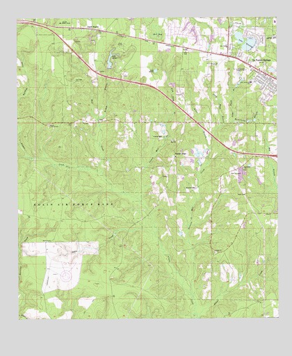
De Funiak Springs West, FL USGS Topographic Map
Click on map above to begin viewing in our Map Viewer.

This topographic map contains these locations and features:
Feature Name Type Latitude Longitude GNIS ID View Map
Alaqua ChurchChurchN30.6524°W86.1552°277723View Map
Alaqua Lookout TowerTowerN30.7052°W86.2341°277725View Map
Alpine HeightsPopulated PlaceN30.7449°W86.2099°277817View Map
Bear Bay BranchStreamN30.6924°W86.2449°278287View Map
Bear CreekStreamN30.6863°W86.2094°278303View Map
Bell BaySwampN30.7432°W86.1824°278411View Map
Bishop BranchStreamN30.7074°W86.2105°278860View Map
Camp EucheeLocaleN30.7388°W86.1980°279897View Map
Cedar Lane AirportAirportN30.7371°W86.2127°309364View Map
Cosson MillPopulated PlaceN30.7002°W86.1811°295220View Map
Cosson MillStreamN30.6724°W86.1894°280874View Map
De Funiak Springs DivisionCivilN30.6479°W86.2395°1935744View Map
DeFuniak Spring Country ClubLocaleN30.7291°W86.1397°281366View Map
DeFuniak Springs AirportAirportN30.7337°W86.1514°309361View Map
DeFuniak Springs Post OfficePost OfficeN30.7227°W86.1253°2759159View Map
DixonPopulated PlaceN30.7396°W86.1324°301680View Map
Fish Pond BranchStreamN30.7013°W86.1766°282491View Map
Galilean AcademySchoolN30.7056°W86.1646°303696View Map
Heidelberg BranchStreamN30.6952°W86.1572°283858View Map
Kiser BranchStreamN30.6899°W86.1583°285144View Map
Lake AlaquaReservoirN30.7306°W86.2050°277727View Map
Lake StanleyLakeN30.7377°W86.1400°291619View Map
Lake Stanley ChurchChurchN30.7391°W86.1486°285283View Map
Lake SylviaLakeN30.7282°W86.1832°291986View Map
Maude Sanders Elementary SchoolSchoolN30.7480°W86.1263°299353View Map
Oak Ridge CemeteryCemeteryN30.7238°W86.2216°287990View Map
Oakie CreekStreamN30.6607°W86.1841°288002View Map
Pleasant RidgePopulated PlaceN30.6930°W86.1741°295550View Map
Sconiers MillPopulated PlaceN30.6796°W86.1638°295604View Map
Sconiers Mill CreekStreamN30.6355°W86.1666°290759View Map
Sconiers Mill PondLakeN30.6898°W86.1624°310006View Map
Southwide ChurchChurchN30.6880°W86.1408°291468View Map
Stage Stand BranchStreamN30.7074°W86.1461°291604View Map
Steele ChurchPopulated PlaceN30.6485°W86.1474°301679View Map
Steep Head BranchStreamN30.7049°W86.1513°291668View Map
Valley Springs HospitalHospitalN30.7260°W86.1377°298815View Map
Walton High SchoolSchoolN30.7419°W86.1258°292858View Map
West DeFuniak SchoolSchoolN30.7232°W86.1372°293053View Map

Note: Coordinates in the location and feature list above are referenced to NAD83 datum.


Copyright (C) 2008-2024 Ryan Niemi / Sunset Dynamics ... All Rights Reserved