TopoQuest Logo
Do you find TopoQuest useful?
Help keep TopoQuest running and adding new maps/features by donating!
Bitcoin:  19c7KJd3qBynnjoSw5npx9KScwjBe4ifkT
Litecoin:  LXs6TkuXGGXo1vDsWCkWVdjQX94eUKd6ui
Home View Maps Find Maps Find Places Resources & Links


De Funiak Springs East, Florida Topographic Map

USGS Map Title: De Funiak Springs East, FL
USGS Map MRC: 30086F1
DRG (GeoTIFF) Download: o30086f1.tif


Neighboring USGS Topographic Map Quads:


  Liberty, FL  
30086G2
 

  Glendale, FL  
30086G1
 

  Prosperity, FL  
30085G8
 

  De Funiak Springs West, FL  
30086F2
 

  De Funiak Springs East, FL  
30086F1
 

  Ponce de Leon, FL  
30085F8
 

  Portland, FL  
30086E2
 

  Rock Hill, FL  
30086E1
 

  Redbay, FL  
30085E8


Map MRC Location:

N31°
W87°
N31°
W86°
H8 H7 H6 H5 H4 H3 H2 H1
G8 G7 G6 G5 G4 G3 G2 G1
F8 F7 F6 F5 F4 F3 F2 F1
E8 E7 E6 E5 E4 E3 E2 E1
D8 D7 D6 D5 D4 D3 D2 D1
C8 C7 C6 C5 C4 C3 C2 C1
B8 B7 B6 B5 B4 B3 B2 B1
A8 A7 A6 A5 A4 A3 A2 A1
N30°
W87°
N30°
W86°

De Funiak Springs East, FL USGS 1:24K Topographic Map Preview:
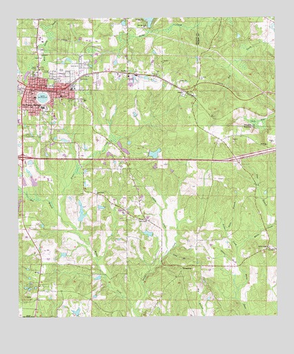
De Funiak Springs East, FL USGS Topographic Map
Click on map above to begin viewing in our Map Viewer.

This topographic map contains these locations and features:
Feature Name Type Latitude Longitude GNIS ID View Map
ArgylePopulated PlaceN30.7196°W86.0444°277944View Map
Argyle ChurchChurchN30.7238°W86.0458°277945View Map
Argyle Post OfficePost OfficeN30.7207°W86.0444°2759152View Map
Argyle Volunteer Fire DepartmentBuildingN30.7188°W86.0398°2644162View Map
Bay BranchStreamN30.6674°W86.1044°278190View Map
C J King Junior PondLakeN30.6980°W86.0710°298142View Map
City of De Funiak SpringsCivilN30.7122°W86.1208°2404200View Map
Cuchens AirportAirportN30.6428°W86.1186°2676633View Map
Davis Lane ChurchChurchN30.7302°W86.0944°281328View Map
Days BranchStreamN30.6630°W86.0033°281350View Map
De Funiak SpringsPopulated PlaceN30.7210°W86.1152°294592View Map
Defuniak Springs Fire DepartmentBuildingN30.7258°W86.1161°2644118View Map
DeFuniak Springs Police DepartmentBuildingN30.7217°W86.1146°2754512View Map
DeFuniak SquareLocaleN30.7060°W86.1222°295825View Map
Euchee Valley ChurchChurchN30.6541°W86.0033°282267View Map
EucheeannaPopulated PlaceN30.6457°W86.0449°295268View Map
Folks CreekStreamN30.6535°W86.0191°282644View Map
Gillis ChapelChurchN30.6660°W86.0638°283081View Map
Goose BranchStreamN30.6605°W86.0244°283188View Map
Healthmark Regional Medical CenterHospitalN30.6600°W86.1175°2094851View Map
Indian CreekStreamN30.6510°W86.0535°284496View Map
Indian Creek ChurchChurchN30.6760°W86.0863°284497View Map
Jack BaySwampN30.7062°W86.0065°284647View Map
KoerberPopulated PlaceN30.7274°W86.0713°285172View Map
Lake DeFuniakReservoirN30.7171°W86.1127°281360View Map
Long BranchStreamN30.6519°W86.0522°285962View Map
Otter BranchStreamN30.6474°W86.0185°288274View Map
Panther CreekStreamN30.6271°W86.0688°288460View Map
S D Ingram Pond OneLakeN30.6703°W86.0942°298151View Map
S D Ingram Pond TwoLakeN30.6671°W86.0941°298152View Map
Saint Johns ChurchChurchN30.6527°W86.0002°290228View Map
Turner Farms AirportAirportN30.6521°W86.1091°309362View Map
WalcanPopulated PlaceN30.7246°W86.0861°301685View Map
Walton County Fire Rescue Station 2 United Emergency Medical ServicesBuildingN30.6620°W86.1209°2644231View Map
Walton County Fire Rescue Station 4BuildingN30.7244°W86.0936°2644622View Map
Walton County Vocational Technical SchoolSchoolN30.7210°W86.0986°299355View Map
Walton Middle SchoolSchoolN30.7129°W86.1129°299354View Map
WGTX-AM (De Funiak Springs)TowerN30.7116°W86.1069°310050View Map
WQUH-FM (De Funiak Springs)TowerN30.7221°W86.1241°310175View Map
WZEP-AM (De Funiak Springs)TowerN30.7288°W86.1174°310052View Map

Note: Coordinates in the location and feature list above are referenced to NAD83 datum.


Copyright (C) 2008-2024 Ryan Niemi / Sunset Dynamics ... All Rights Reserved