TopoQuest Logo
Do you find TopoQuest useful?
Help keep TopoQuest running and adding new maps/features by donating!
Bitcoin:  19c7KJd3qBynnjoSw5npx9KScwjBe4ifkT
Litecoin:  LXs6TkuXGGXo1vDsWCkWVdjQX94eUKd6ui
Home View Maps Find Maps Find Places Resources & Links


Eminence, Indiana Topographic Map

USGS Map Title: Eminence, IN
USGS Map MRC: 39086E6
DRG (GeoTIFF) Download: o39086e6.tif


Neighboring USGS Topographic Map Quads:


  Greencastle, IN  
39086F7
 

  Coatesville, IN  
39086F6
 

  Clayton, IN  
39086F5
 

  Cloverdale, IN  
39086E7
 

  Eminence, IN  
39086E6
 

  Hall, IN  
39086E5
 

  Cataract, IN  
39086D7
 

  Quincy, IN  
39086D6
 

  Paragon, IN  
39086D5


Map MRC Location:

N40°
W87°
N40°
W86°
H8 H7 H6 H5 H4 H3 H2 H1
G8 G7 G6 G5 G4 G3 G2 G1
F8 F7 F6 F5 F4 F3 F2 F1
E8 E7 E6 E5 E4 E3 E2 E1
D8 D7 D6 D5 D4 D3 D2 D1
C8 C7 C6 C5 C4 C3 C2 C1
B8 B7 B6 B5 B4 B3 B2 B1
A8 A7 A6 A5 A4 A3 A2 A1
N39°
W87°
N39°
W86°

Eminence, IN USGS 1:24K Topographic Map Preview:
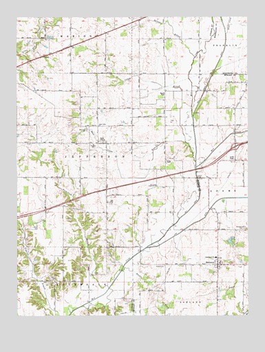
Eminence, IN USGS Topographic Map
Click on map above to begin viewing in our Map Viewer.

This topographic map contains these locations and features:
Feature Name Type Latitude Longitude GNIS ID View Map
A and A Township Fire Station 11BuildingN39.5211°W86.6418°2701423View Map
A and A Township Volunteer Fire Department Station 1BuildingN39.5211°W86.6419°2625753View Map
A and A Township Volunteer Fire Department Station 2BuildingN39.5217°W86.6449°2626136View Map
Belle UnionPopulated PlaceN39.5731°W86.7061°430776View Map
Belle Union BranchStreamN39.5645°W86.6533°449477View Map
Belle Union Branch CemeteryCemeteryN39.5646°W86.6533°445052View Map
Belle Union Elementary SchoolSchoolN39.5720°W86.7086°447157View Map
Board ParkPopulated PlaceN39.5928°W86.6700°431268View Map
Broad ParkPopulated PlaceN39.5859°W86.6694°447638View Map
Cotton BranchStreamN39.5723°W86.6589°433017View Map
EminencePopulated PlaceN39.5214°W86.6414°434166View Map
Eminence Consolidated SchoolSchoolN39.5245°W86.6425°447334View Map
Jefferson Township Volunteer Fire DepartmentBuildingN39.5724°W86.7043°2626138View Map
Little PointPopulated PlaceN39.5650°W86.6319°449686View Map
Mill Creek CemeteryCemeteryN39.5778°W86.7123°439163View Map
Mill Creek DitchCanalN39.5812°W86.6544°439167View Map
Mud CreekStreamN39.5623°W86.6531°439807View Map
Pam's Place AirportAirportN39.5011°W86.6874°2676980View Map
Plum CreekStreamN39.6184°W86.6367°441365View Map
Rhodes CreekStreamN39.5189°W86.6933°441929View Map
Sallust BranchStreamN39.6084°W86.6536°442935View Map
Township of JeffersonCivilN39.5710°W86.7200°453497View Map
Tri-County Community ChurchChurchN39.5542°W86.6742°444876View Map
Union BranchStreamN39.5725°W86.6586°445049View Map
Union Valley ChurchChurchN39.5798°W86.7056°445134View Map
Vermillion BranchStreamN39.5117°W86.7006°445249View Map
Walnut ChapelChurchN39.5642°W86.6694°445404View Map
Walters CemeteryCemeteryN39.5209°W86.6702°445448View Map
Whispering Wind LakeReservoirN39.5310°W86.6340°447889View Map
Whispering Wind Lake DamDamN39.5317°W86.6367°447888View Map
Whitaker - Patrick CemeteryCemeteryN39.5365°W86.6273°445915View Map

Note: Coordinates in the location and feature list above are referenced to NAD83 datum.


Copyright (C) 2008-2025 Ryan Niemi / Sunset Dynamics ... All Rights Reserved