TopoQuest Logo
Do you find TopoQuest useful?
Help keep TopoQuest running and adding new maps/features by donating!
Bitcoin:  19c7KJd3qBynnjoSw5npx9KScwjBe4ifkT
Litecoin:  LXs6TkuXGGXo1vDsWCkWVdjQX94eUKd6ui
Home View Maps Find Maps Find Places Resources & Links


Coatesville, Indiana Topographic Map

USGS Map Title: Coatesville, IN
USGS Map MRC: 39086F6
DRG (GeoTIFF) Download: o39086f6.tif


Neighboring USGS Topographic Map Quads:


  Roachdale, IN  
39086G7
 

  North Salem, IN  
39086G6
 

  Danville, IN  
39086G5
 

  Greencastle, IN  
39086F7
 

  Coatesville, IN  
39086F6
 

  Clayton, IN  
39086F5
 

  Cloverdale, IN  
39086E7
 

  Eminence, IN  
39086E6
 

  Hall, IN  
39086E5


Map MRC Location:

N40°
W87°
N40°
W86°
H8 H7 H6 H5 H4 H3 H2 H1
G8 G7 G6 G5 G4 G3 G2 G1
F8 F7 F6 F5 F4 F3 F2 F1
E8 E7 E6 E5 E4 E3 E2 E1
D8 D7 D6 D5 D4 D3 D2 D1
C8 C7 C6 C5 C4 C3 C2 C1
B8 B7 B6 B5 B4 B3 B2 B1
A8 A7 A6 A5 A4 A3 A2 A1
N39°
W87°
N39°
W86°

Coatesville, IN USGS 1:24K Topographic Map Preview:
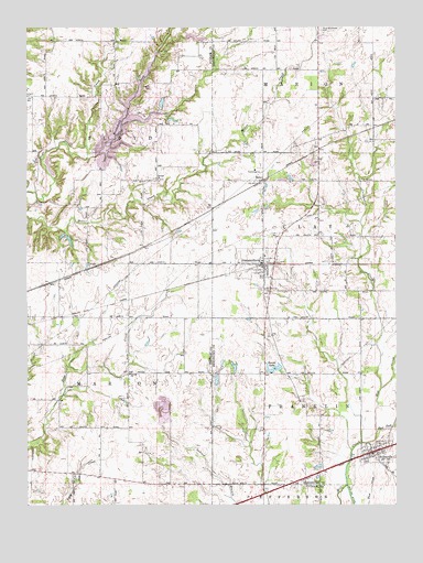
Coatesville, IN USGS Topographic Map
Click on map above to begin viewing in our Map Viewer.

This topographic map contains these locations and features:
Feature Name Type Latitude Longitude GNIS ID View Map
Banks LakeReservoirN39.6945°W86.7355°448813View Map
Banks Lake DamDamN39.6934°W86.7350°448814View Map
Bethel ChurchChurchN39.6587°W86.7158°430930View Map
Canaan ChurchChurchN39.7100°W86.7061°432096View Map
Clear Creek CemeteryCemeteryN39.7342°W86.7077°446828View Map
CoatesvillePopulated PlaceN39.6878°W86.6703°432714View Map
Coatesville CemeteryCemeteryN39.6801°W86.6688°2093772View Map
Crittenden CreekStreamN39.6550°W86.6300°433137View Map
East Fork Mill CreekStreamN39.6437°W86.6319°433894View Map
Elmer Martens LakeReservoirN39.7475°W86.6924°448905View Map
Elmer Martens Lake DamDamN39.7467°W86.6950°448906View Map
Floyd Township Fire and RescueBuildingN39.7131°W86.7273°2626624View Map
Hebron Presbyterian CemeteryCemeteryN39.6526°W86.6729°2093822View Map
Heritage LakeReservoirN39.7242°W86.7174°446677View Map
Heritage LakePopulated PlaceN39.7278°W86.7102°2629900View Map
Heritage Lake Census Designated PlaceCensusN39.7288°W86.7122°2629871View Map
Heritage Lake DamDamN39.7181°W86.7270°448542View Map
Liberty CemeteryCemeteryN39.6526°W86.7168°437820View Map
Malta Station Post Office (historical)Post OfficeN39.6848°W86.7375°453036View Map
Mill Creek DitchCanalN39.6264°W86.6408°439166View Map
Mill Creek Fire Department Station 161BuildingN39.6883°W86.6716°2626025View Map
Mill Creek Fire Department Station 71BuildingN39.6395°W86.6331°2626235View Map
Monachals ForkStreamN39.7170°W86.7292°449545View Map
Moravian CemeteryCemeteryN39.6842°W86.6710°2093774View Map
New Winchester CemeteryCemeteryN39.7493°W86.6502°440128View Map
Oleo AirportAirportN39.7361°W86.7277°2676935View Map
Pleasant Hill CemeteryCemeteryN39.6646°W86.6431°2095538View Map
RenoPopulated PlaceN39.7103°W86.6703°441898View Map
StilesvillePopulated PlaceN39.6384°W86.6336°444163View Map
Stilesville CemeteryCemeteryN39.6410°W86.6304°2093824View Map
Stilesville Elementary SchoolSchoolN39.6395°W86.6331°447015View Map
Sunset LakeReservoirN39.6608°W86.6661°444425View Map
Sunset Lake DamDamN39.6603°W86.6647°448721View Map
Town of CoatesvilleCivilN39.6881°W86.6698°2396657View Map
Town of StilesvilleCivilN39.6371°W86.6343°2397682View Map
Township of FloydCivilN39.7324°W86.7402°453298View Map
Township of MarionCivilN39.6450°W86.7409°453612View Map
Vaughn Airport (historical)AirportN39.6323°W86.6336°449355View Map
West Branch Friends CemeteryCemeteryN39.6884°W86.6646°2093776View Map

Note: Coordinates in the location and feature list above are referenced to NAD83 datum.


Copyright (C) 2008-2024 Ryan Niemi / Sunset Dynamics ... All Rights Reserved