TopoQuest Logo
Do you find TopoQuest useful?
Help keep TopoQuest running and adding new maps/features by donating!
Bitcoin:  19c7KJd3qBynnjoSw5npx9KScwjBe4ifkT
Litecoin:  LXs6TkuXGGXo1vDsWCkWVdjQX94eUKd6ui
Home View Maps Find Maps Find Places Resources & Links


Canadys, South Carolina Topographic Map

USGS Map Title: Canadys, SC
USGS Map MRC: 33080A5
DRG (GeoTIFF) Download: o33080a5.tif


Neighboring USGS Topographic Map Quads:


  Reevesville, SC  
33080B6
 

  Saint George, SC  
33080B5
 

  Harleyville, SC  
33080B4
 

  Saint George SW, SC  
33080A6
 

  Canadys, SC  
33080A5
 

  Maple Cane Swamp, SC  
33080A4
 

  Walterboro, SC  
32080H6
 

  Round O, SC  
32080H5
 

  Cottageville, SC  
32080H4


Map MRC Location:

N34°
W81°
N34°
W80°
H8 H7 H6 H5 H4 H3 H2 H1
G8 G7 G6 G5 G4 G3 G2 G1
F8 F7 F6 F5 F4 F3 F2 F1
E8 E7 E6 E5 E4 E3 E2 E1
D8 D7 D6 D5 D4 D3 D2 D1
C8 C7 C6 C5 C4 C3 C2 C1
B8 B7 B6 B5 B4 B3 B2 B1
A8 A7 A6 A5 A4 A3 A2 A1
N33°
W81°
N33°
W80°

Canadys, SC USGS 1:24K Topographic Map Preview:
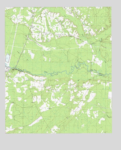
Canadys, SC USGS Topographic Map
Click on map above to begin viewing in our Map Viewer.

This topographic map contains these locations and features:
Feature Name Type Latitude Longitude GNIS ID View Map
Bethany ChurchChurchN33.0252°W80.5407°1220528View Map
Bethel ChurchChurchN33.0149°W80.5515°1240556View Map
Bridge CemeteryCemeteryN33.0535°W80.5582°1240570View Map
CanadysPopulated PlaceN33.0557°W80.6204°1251831View Map
Canadys BridgeBridgeN33.0646°W80.6132°1247137View Map
Canadys CemeteryCemeteryN33.0585°W80.6182°1240576View Map
Canadys Post OfficePost OfficeN33.0556°W80.6204°2489777View Map
Canadys Steam Electric Generating PlantBuildingN33.0649°W80.6226°1240577View Map
Cane IslandIslandN33.0577°W80.5023°1221313View Map
Colleton County Fire Department Station 5BuildingN33.0545°W80.6163°2368121View Map
Colleton State ParkParkN33.0638°W80.6157°1240595View Map
GroverPopulated PlaceN33.1052°W80.5948°1222923View Map
Grover Fire DepartmentBuildingN33.1061°W80.5956°2368299View Map
Grover Methodist Episcopal Church SouthChurchN33.1063°W80.5940°1241115View Map
Grover Post OfficePost OfficeN33.1059°W80.5936°2489835View Map
Gruber CemeteryCemeteryN33.0499°W80.5340°1240631View Map
Hiott CemeteryCemeteryN33.0463°W80.5362°1240642View Map
Indian Field SwampStreamN33.0821°W80.5159°1246117View Map
Jenkins Swamp School (historical)SchoolN33.0771°W80.5415°1241131View Map
Jerusalem ChurchChurchN33.0932°W80.5973°1223561View Map
Johnstons Mill (historical)LocaleN33.0910°W80.5123°1241132View Map
Lee BranchStreamN33.1218°W80.5607°1223861View Map
Lower Grover SchoolSchoolN33.1041°W80.5554°1224211View Map
Maple Cane SchoolSchoolN33.0307°W80.5357°1224300View Map
Mission School (historical)SchoolN33.0299°W80.5651°1240679View Map
Murray CemeteryCemeteryN33.0963°W80.5620°1241228View Map
Oak Grove ChurchChurchN33.0246°W80.5720°1240690View Map
Oak Grove SchoolSchoolN33.0304°W80.5493°1225112View Map
Polk SwampStreamN33.0585°W80.5073°1250206View Map
Providence CemeteryCemeteryN33.0332°W80.6140°1240712View Map
Providence ChurchChurchN33.0313°W80.5915°1225694View Map
Providence SchoolSchoolN33.0246°W80.5873°1225700View Map
Redbank DrainStreamN33.0643°W80.6190°1250315View Map
Redbank SchoolSchoolN33.0532°W80.6229°1225793View Map
Saint Luke School (historical)SchoolN33.0974°W80.5993°1241194View Map
Saint Lukes ChurchChurchN33.0968°W80.5993°1250571View Map
Saint Marks CemeteryCemeteryN33.1196°W80.5462°1241198View Map
Saint Matthews ChurchChurchN33.0968°W80.5493°1241200View Map
SCE and G Ash PondReservoirN33.0748°W80.6219°1239411View Map
SCE and G Ash Pond Dam D-2555DamN33.0718°W80.6198°1239410View Map
Seigler CemeteryCemeteryN33.1188°W80.5770°1241210View Map
Skull BranchStreamN33.0574°W80.5137°1250921View Map
Skull Branch SchoolSchoolN33.0379°W80.5568°1226664View Map
Stokes BridgeBridgeN33.0613°W80.5259°1226897View Map
Utsey CemeteryCemeteryN33.1004°W80.5937°1241256View Map
Wallace CemeteryCemeteryN33.0985°W80.5782°1241257View Map
Westbury CemeteryCemeteryN33.1213°W80.5912°1241264View Map

Note: Coordinates in the location and feature list above are referenced to NAD83 datum.


Copyright (C) 2008-2025 Ryan Niemi / Sunset Dynamics ... All Rights Reserved