TopoQuest Logo
Do you find TopoQuest useful?
Help keep TopoQuest running and adding new maps/features by donating!
Bitcoin:  19c7KJd3qBynnjoSw5npx9KScwjBe4ifkT
Litecoin:  LXs6TkuXGGXo1vDsWCkWVdjQX94eUKd6ui
Home View Maps Find Maps Find Places Resources & Links


Gaines, Missouri Topographic Map

USGS Map Title: Gaines, MO
USGS Map MRC: 38093C6
DRG (GeoTIFF) Download: o38093c6.tif


Neighboring USGS Topographic Map Quads:


  Clinton North, MO  
38093D7
 

  Calhoun West, MO  
38093D6
 

  Calhoun East, MO  
38093D5
 

  Clinton South, MO  
38093C7
 

  Gaines, MO  
38093C6
 

  Leesville, MO  
38093C5
 

  Ohio, MO  
38093B7
 

  Lowry City, MO  
38093B6
 

  Ninnescah Park, MO  
38093B5


Map MRC Location:

N39°
W94°
N39°
W93°
H8 H7 H6 H5 H4 H3 H2 H1
G8 G7 G6 G5 G4 G3 G2 G1
F8 F7 F6 F5 F4 F3 F2 F1
E8 E7 E6 E5 E4 E3 E2 E1
D8 D7 D6 D5 D4 D3 D2 D1
C8 C7 C6 C5 C4 C3 C2 C1
B8 B7 B6 B5 B4 B3 B2 B1
A8 A7 A6 A5 A4 A3 A2 A1
N38°
W94°
N38°
W93°

Gaines, MO USGS 1:24K Topographic Map Preview:
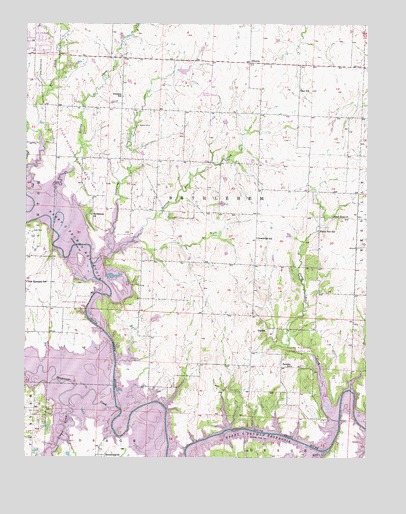
Gaines, MO USGS Topographic Map
Click on map above to begin viewing in our Map Viewer.

This topographic map contains these locations and features:
Feature Name Type Latitude Longitude GNIS ID View Map
AlbertaPopulated PlaceN38.3639°W93.6697°740621View Map
Bethlehem ChurchChurchN38.3197°W93.7266°714096View Map
Bethlehem School (historical)SchoolN38.3140°W93.7117°714111View Map
Blanchard (historical)LocaleN38.3281°W93.7347°740254View Map
Clinton Regional AirportAirportN38.3588°W93.6831°758643View Map
Cooper CreekStreamN38.2650°W93.7335°755927View Map
Cooper Creek Public Use AreaParkN38.2625°W93.7427°742820View Map
Deepwater CreekStreamN38.2645°W93.7166°716791View Map
Dillion CreekStreamN38.3147°W93.7391°716900View Map
Dumpling CreekStreamN38.3092°W93.7194°717168View Map
E Burns DamDamN38.3600°W93.6919°762912View Map
Englewood CemeteryCemeteryN38.3636°W93.7450°717592View Map
Freedom School (historical)SchoolN38.3540°W93.7147°718202View Map
GainesPopulated PlaceN38.2872°W93.6616°740862View Map
Good Hope ChurchChurchN38.3195°W93.6380°718554View Map
Greenridge School (historical)SchoolN38.3134°W93.6655°718826View Map
Hay CreekStreamN38.2517°W93.6397°756165View Map
Hilty MineMineN38.3150°W93.7485°719627View Map
New Harmony School (historical)SchoolN38.3003°W93.7497°723213View Map
Pretty Bob CreekStreamN38.2606°W93.6355°736338View Map
Pretty Bob School (historical)SchoolN38.3153°W93.6433°729806View Map
Richland School (historical)SchoolN38.2734°W93.6960°725277View Map
SparrowPopulated PlaceN38.3367°W93.7152°740253View Map
Sparrow Foot CreekStreamN38.3053°W93.7260°729816View Map
Sparrow Post Office (historical)Post OfficeN38.3367°W93.7152°745101View Map
Sparrowfoot Public Use AreaParkN38.2964°W93.7266°742819View Map
Star School (historical)SchoolN38.3559°W93.6500°727021View Map
Stotts Lake DamDamN38.3384°W93.7085°763441View Map
Surprise School (historical)SchoolN38.2764°W93.6524°727341View Map
Township of BethlehemCivilN38.3211°W93.6804°766734View Map
Wastell MineMineN38.3456°W93.7102°728391View Map
White Lake DamDamN38.2900°W93.7035°763301View Map

Note: Coordinates in the location and feature list above are referenced to NAD83 datum.


Copyright (C) 2008-2025 Ryan Niemi / Sunset Dynamics ... All Rights Reserved