TopoQuest Logo
Do you find TopoQuest useful?
Help keep TopoQuest running and adding new maps/features by donating!
Bitcoin:  19c7KJd3qBynnjoSw5npx9KScwjBe4ifkT
Litecoin:  LXs6TkuXGGXo1vDsWCkWVdjQX94eUKd6ui
Home View Maps Find Maps Find Places Resources & Links


Calhoun West, Missouri Topographic Map

USGS Map Title: Calhoun West, MO
USGS Map MRC: 38093D6
DRG (GeoTIFF) Download: o38093d6.tif


Neighboring USGS Topographic Map Quads:


  Chilhowee, MO  
38093E7
 

  Leeton, MO  
38093E6
 

  Windsor, MO  
38093E5
 

  Clinton North, MO  
38093D7
 

  Calhoun West, MO  
38093D6
 

  Calhoun East, MO  
38093D5
 

  Clinton South, MO  
38093C7
 

  Gaines, MO  
38093C6
 

  Leesville, MO  
38093C5


Map MRC Location:

N39°
W94°
N39°
W93°
H8 H7 H6 H5 H4 H3 H2 H1
G8 G7 G6 G5 G4 G3 G2 G1
F8 F7 F6 F5 F4 F3 F2 F1
E8 E7 E6 E5 E4 E3 E2 E1
D8 D7 D6 D5 D4 D3 D2 D1
C8 C7 C6 C5 C4 C3 C2 C1
B8 B7 B6 B5 B4 B3 B2 B1
A8 A7 A6 A5 A4 A3 A2 A1
N38°
W94°
N38°
W93°

Calhoun West, MO USGS 1:24K Topographic Map Preview:
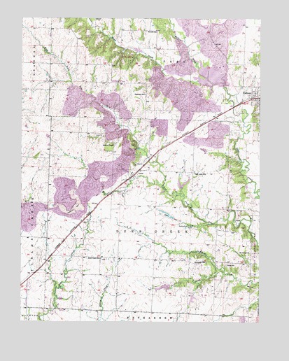
Calhoun West, MO USGS Topographic Map
Click on map above to begin viewing in our Map Viewer.

This topographic map contains these locations and features:
Feature Name Type Latitude Longitude GNIS ID View Map
Bronaugh Church (historical)ChurchN38.3989°W93.6536°745041View Map
Bronaugh School (historical)SchoolN38.3995°W93.6530°714738View Map
CalhounPopulated PlaceN38.4672°W93.6263°715194View Map
Calhoun CemeteryCemeteryN38.4580°W93.6265°2702279View Map
Calhoun Elementary SchoolSchoolN38.4638°W93.6256°745487View Map
Calhoun High SchoolSchoolN38.4641°W93.6256°2743831View Map
City of CalhounCivilN38.4684°W93.6251°2393494View Map
Clinton Memory GardensCemeteryN38.3897°W93.7453°2702280View Map
Combs CemeteryCemeteryN38.3986°W93.6424°716148View Map
Connor O. Fewel Conservation AreaParkN38.4719°W93.7044°2572643View Map
Deer Creek School (historical)SchoolN38.4011°W93.7085°716804View Map
Dody Lake DamDamN38.3900°W93.6719°763439View Map
Drakes ChapelChurchN38.4481°W93.7019°717046View Map
East Lake School (historical)SchoolN38.4361°W93.6594°729731View Map
Harrelson CreekStreamN38.3947°W93.6435°723117View Map
Highland School (historical)SchoolN38.4689°W93.6852°719576View Map
Hinton Lake DamDamN38.4450°W93.6535°763300View Map
Hutcherson Lake DamDamN38.4300°W93.6652°763438View Map
LewisPopulated PlaceN38.4353°W93.6916°720930View Map
Lewis School (historical)SchoolN38.4442°W93.6977°720947View Map
Merritt School (historical)SchoolN38.4950°W93.6797°722243View Map
Mount Gilead ChurchChurchN38.4036°W93.6299°722753View Map
Number 111 LakeReservoirN38.4757°W93.6504°763033View Map
O'Dell LakeReservoirN38.3762°W93.6338°763047View Map
O'Dell Lake DamDamN38.3767°W93.6335°763046View Map
Plum Grove School (historical)SchoolN38.4831°W93.6435°724668View Map
Redding MineMineN38.4145°W93.6627°725171View Map
Spangler MineMineN38.4215°W93.7221°2572642View Map
Tebo Freshwater Lake DamDamN38.4734°W93.6435°763032View Map
Township of Deer CreekCivilN38.4187°W93.6801°766740View Map
Union School (historical)SchoolN38.4806°W93.7263°745464View Map
Wade CreekStreamN38.4734°W93.6499°728234View Map
Wall Lake DamDamN38.3867°W93.6602°763440View Map

Note: Coordinates in the location and feature list above are referenced to NAD83 datum.


Copyright (C) 2008-2025 Ryan Niemi / Sunset Dynamics ... All Rights Reserved