TopoQuest Logo
Do you find TopoQuest useful?
Help keep TopoQuest running and adding new maps/features by donating!
Bitcoin:  19c7KJd3qBynnjoSw5npx9KScwjBe4ifkT
Litecoin:  LXs6TkuXGGXo1vDsWCkWVdjQX94eUKd6ui
Home View Maps Find Maps Find Places Resources & Links


Gillette Mountain, Washington Topographic Map

USGS Map Title: Gillette Mountain, WA
USGS Map MRC: 48117F7
DRG (GeoTIFF) Download: o48117f7.tif


Neighboring USGS Topographic Map Quads:


  China Bend, WA  
48117G8
 

  Onion Creek, WA  
48117G7
 

  Spirit, WA  
48117G6
 

  Echo Valley, WA  
48117F8
 

  Gillette Mountain, WA  
48117F7
 

  Aladdin, WA  
48117F6
 

  Colville, WA  
48117E8
 

  White Mud Lake, WA  
48117E7
 

  Park Rapids, WA  
48117E6


Map MRC Location:

N49°
W118°
N49°
W117°
H8 H7 H6 H5 H4 H3 H2 H1
G8 G7 G6 G5 G4 G3 G2 G1
F8 F7 F6 F5 F4 F3 F2 F1
E8 E7 E6 E5 E4 E3 E2 E1
D8 D7 D6 D5 D4 D3 D2 D1
C8 C7 C6 C5 C4 C3 C2 C1
B8 B7 B6 B5 B4 B3 B2 B1
A8 A7 A6 A5 A4 A3 A2 A1
N48°
W118°
N48°
W117°

Gillette Mountain, WA USGS 1:24K Topographic Map Preview:
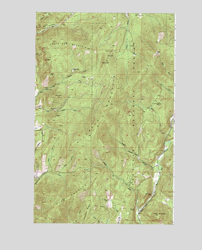
Gillette Mountain, WA USGS Topographic Map
Click on map above to begin viewing in our Map Viewer.

This topographic map contains these locations and features:
Feature Name Type Latitude Longitude GNIS ID View Map
BaldySummitN48.7127°W117.8605°1516092View Map
Big Chief MineMineN48.7035°W117.8642°1516475View Map
Binger CanyonValleyN48.6577°W117.7686°1516565View Map
Chloride Queen MineMineN48.6919°W117.8578°1517736View Map
Churchill RidgeRidgeN48.6355°W117.8208°1517775View Map
ComstockSummitN48.6996°W117.8542°1517999View Map
Davis CanyonValleyN48.6541°W117.8536°1518499View Map
Echo MineMineN48.7046°W117.8650°1519172View Map
Galena Farm MineMineN48.7280°W117.8061°1519875View Map
Galena Knob MineMineN48.6957°W117.7639°1519876View Map
Gillette MountainSummitN48.6888°W117.8150°1519963View Map
Green MountainSummitN48.7149°W117.7816°1530130View Map
Howard MeadowsFlatN48.7413°W117.8636°1520996View Map
Indian CreekStreamN48.6549°W117.8639°1521169View Map
Jumpoff Joe BluffCliffN48.6421°W117.7733°1521505View Map
Jumpoff Joe CreekStreamN48.6310°W117.7814°1521389View Map
Little RoundtopSummitN48.6299°W117.7639°1530984View Map
Lucky Boy MineMineN48.7249°W117.8055°1522564View Map
Marble CreekStreamN48.6691°W117.7575°1522703View Map
Marble QuarryMineN48.7113°W117.8322°1522713View Map
Mount RogersSummitN48.7257°W117.7661°1525191View Map
Neglected MineMineN48.7216°W117.8644°1523605View Map
Old DouglasSummitN48.6382°W117.8491°1524000View Map
Onion MountainSummitN48.7210°W117.8119°1524062View Map
Reed RanchLocaleN48.7160°W117.8408°1524975View Map
Shoemaker MineMineN48.6324°W117.7858°1525695View Map
Staghorn MountainSummitN48.7491°W117.8650°1526477View Map
Strauss CreekStreamN48.6552°W117.7630°1517419View Map
Tenderfoot MineMineN48.6880°W117.8555°1526992View Map
Uncle Sam MountainSummitN48.7310°W117.8480°1527602View Map

Note: Coordinates in the location and feature list above are referenced to NAD83 datum.


Copyright (C) 2008-2024 Ryan Niemi / Sunset Dynamics ... All Rights Reserved