TopoQuest Logo
Do you find TopoQuest useful?
Help keep TopoQuest running and adding new maps/features by donating!
Bitcoin:  19c7KJd3qBynnjoSw5npx9KScwjBe4ifkT
Litecoin:  LXs6TkuXGGXo1vDsWCkWVdjQX94eUKd6ui
Home View Maps Find Maps Find Places Resources & Links


Lake Killarney, Missouri Topographic Map

USGS Map Title: Lake Killarney, MO
USGS Map MRC: 37090E5
DRG (GeoTIFF) Download: o37090e5.tif


Neighboring USGS Topographic Map Quads:


  Graniteville, MO  
37090F6
 

  Iron Mountain Lake, MO  
37090F5
 

  Wachita Mountain, MO  
37090F4
 

  Ironton, MO  
37090E6
 

  Lake Killarney, MO  
37090E5
 

  Rhodes Mountain, MO  
37090E4
 

  Glover, MO  
37090D6
 

  Des Arc NE, MO  
37090D5
 

  Rock Pile Mountain, MO  
37090D4


Map MRC Location:

N38°
W91°
N38°
W90°
H8 H7 H6 H5 H4 H3 H2 H1
G8 G7 G6 G5 G4 G3 G2 G1
F8 F7 F6 F5 F4 F3 F2 F1
E8 E7 E6 E5 E4 E3 E2 E1
D8 D7 D6 D5 D4 D3 D2 D1
C8 C7 C6 C5 C4 C3 C2 C1
B8 B7 B6 B5 B4 B3 B2 B1
A8 A7 A6 A5 A4 A3 A2 A1
N37°
W91°
N37°
W90°

Lake Killarney, MO USGS 1:24K Topographic Map Preview:
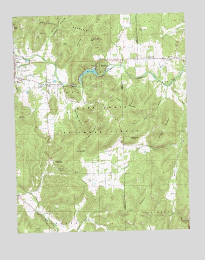
Lake Killarney, MO USGS Topographic Map
Click on map above to begin viewing in our Map Viewer.

This topographic map contains these locations and features:
Feature Name Type Latitude Longitude GNIS ID View Map
Allgier CemeteryCemeteryN37.5292°W90.5726°713235View Map
Arcadia Valley Bible CampLocaleN37.5926°W90.5576°755537View Map
Arcadia Valley CemeteryCemeteryN37.5937°W90.6190°748607View Map
Arcadia Valley Golf ClubLocaleN37.5909°W90.6140°754988View Map
Ashebrand Furnace (historical)LocaleN37.5873°W90.5779°736652View Map
Barren HollowValleyN37.5478°W90.5057°748690View Map
Barren Hollow SchoolSchoolN37.5159°W90.5154°753429View Map
Blankenship MountainSummitN37.5528°W90.5421°748905View Map
Blanton CemeteryCemeteryN37.5464°W90.5554°748906View Map
Blue Mountain CampLocaleN37.5562°W90.5015°748930View Map
Blue Mountain Methodist Camp Lake DamDamN37.5601°W90.5001°763690View Map
Brown CemeteryCemeteryN37.6006°W90.5490°753422View Map
Brown MountainSummitN37.5706°W90.5460°749043View Map
Cherokee Pass Volunteer Fire Department Station 3BuildingN37.5991°W90.5070°2620861View Map
Cord Wood HillSummitN37.6209°W90.6165°736651View Map
Cove CemeteryCemeteryN37.5770°W90.5851°749501View Map
Cove SchoolSchoolN37.5778°W90.5862°753424View Map
Crane MountainSummitN37.5670°W90.6232°749512View Map
Devils Den HollowValleyN37.5703°W90.5821°749641View Map
Flatwoods SchoolSchoolN37.5339°W90.5554°753425View Map
Froe HollowValleyN37.5939°W90.5887°750004View Map
Grassy MountainSummitN37.5534°W90.5648°750111View Map
Grell CemeteryCemeteryN37.5331°W90.5459°750163View Map
Hastings Limestone QuarryMineN37.5778°W90.6207°736650View Map
Hopewell Church (historical)ChurchN37.5039°W90.5965°753428View Map
Iron County FarmLocaleN37.5909°W90.5971°754363View Map
Ironton HollowValleyN37.6023°W90.6023°750467View Map
Kelley MountainSummitN37.5123°W90.5448°750574View Map
Killarney ShoresPopulated PlaceN37.5951°W90.5654°750601View Map
Knob CreekStreamN37.6003°W90.6143°756255View Map
Lake KillarneyReservoirN37.5929°W90.5709°758298View Map
Lake Killarney DamDamN37.5901°W90.5651°763575View Map
Little KnobSummitN37.6101°W90.5896°750777View Map
Long Gravel BranchStreamN37.5826°W90.5135°750846View Map
McLard HillSummitN37.6159°W90.5337°751004View Map
Mount Hope ChurchChurchN37.5989°W90.5123°751179View Map
Peck MountainSummitN37.6208°W90.6166°737186View Map
Pilot KnobSummitN37.6189°W90.6248°751593View Map
Rebel CemeteryCemeteryN37.5312°W90.5584°753426View Map
Red SchoolSchoolN37.5092°W90.6023°753427View Map
Rock CreekStreamN37.5859°W90.5085°751921View Map
RosellePopulated PlaceN37.5995°W90.5260°751964View Map
Royer CemeteryCemeteryN37.5209°W90.5129°751977View Map
Russell CemeteryCemeteryN37.5906°W90.6174°751986View Map
Russell Limestone QuarryMineN37.5953°W90.6207°736649View Map
RussellvillePopulated PlaceN37.5917°W90.6196°736648View Map
Saint Francois MountainsRangeN37.6223°W90.6223°748489View Map
Shut-InsRapidsN37.5846°W90.5815°752148View Map
Sunny Slope SpringSpringN37.5864°W90.5979°753423View Map
Sutton CemeteryCemeteryN37.5112°W90.6021°752446View Map
Tabernacle ChurchChurchN37.5981°W90.5140°752475View Map
Tims MountainSummitN37.5467°W90.5818°752546View Map
Turkey Foot MountainSummitN37.5409°W90.5904°752605View Map
Van East MountainSummitN37.5576°W90.5165°752689View Map
Wagon Wheel GapGapN37.6112°W90.5685°752726View Map
WilsonvillePopulated PlaceN37.6012°W90.6232°736647View Map

Note: Coordinates in the location and feature list above are referenced to NAD83 datum.


Copyright (C) 2008-2024 Ryan Niemi / Sunset Dynamics ... All Rights Reserved