TopoQuest Logo
Do you find TopoQuest useful?
Help keep TopoQuest running and adding new maps/features by donating!
Bitcoin:  19c7KJd3qBynnjoSw5npx9KScwjBe4ifkT
Litecoin:  LXs6TkuXGGXo1vDsWCkWVdjQX94eUKd6ui
Home View Maps Find Maps Find Places Resources & Links


Parkin, Arkansas Topographic Map

USGS Map Title: Parkin, AR
USGS Map MRC: 35090C5
DRG (GeoTIFF) Download: o35090c5.tif


Neighboring USGS Topographic Map Quads:


  Cherry Valley East, AR  
35090D6
 

  Monterey, AR  
35090D5
 

  Joyland, AR  
35090D4
 

  Princedale, AR  
35090C6
 

  Parkin, AR  
35090C5
 

  Earle, AR  
35090C4
 

  Wittsburg, AR  
35090B6
 

  Gieseck, AR  
35090B5
 

  Jeanette, AR  
35090B4


Map MRC Location:

N36°
W91°
N36°
W90°
H8 H7 H6 H5 H4 H3 H2 H1
G8 G7 G6 G5 G4 G3 G2 G1
F8 F7 F6 F5 F4 F3 F2 F1
E8 E7 E6 E5 E4 E3 E2 E1
D8 D7 D6 D5 D4 D3 D2 D1
C8 C7 C6 C5 C4 C3 C2 C1
B8 B7 B6 B5 B4 B3 B2 B1
A8 A7 A6 A5 A4 A3 A2 A1
N35°
W91°
N35°
W90°

Parkin, AR USGS 1:24K Topographic Map Preview:
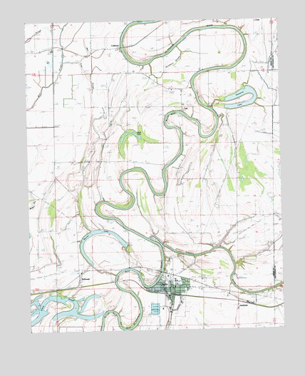
Parkin, AR USGS Topographic Map
Click on map above to begin viewing in our Map Viewer.

This topographic map contains these locations and features:
Feature Name Type Latitude Longitude GNIS ID View Map
Ash BendBendN35.2515°W90.5779°45940View Map
Barnes LakeLakeN35.2905°W90.5883°75633View Map
Barrow BendBendN35.2587°W90.5865°46124View Map
Belknap (historical)Populated PlaceN35.2668°W90.6151°61627View Map
Burr PlaceLocaleN35.3568°W90.5684°82775View Map
Burr SchoolSchoolN35.3631°W90.5790°76471View Map
City of ParkinCivilN35.2633°W90.5529°2404481View Map
ColdwaterPopulated PlaceN35.3645°W90.5790°57567View Map
Coldwater School (historical)SchoolN35.3640°W90.5787°82776View Map
Colton CrossingPopulated PlaceN35.3654°W90.6123°82808View Map
Dunn (historical)Populated PlaceN35.2693°W90.5721°61642View Map
Egypt ChurchChurchN35.3009°W90.5326°48826View Map
Love PlacePopulated PlaceN35.3165°W90.5737°58092View Map
Macedonia ChurchChurchN35.3715°W90.5776°51579View Map
McDonaldPopulated PlaceN35.2701°W90.6021°58145View Map
McDonald CemeteryCemeteryN35.2683°W90.6068°51821View Map
McDonald ChurchChurchN35.2756°W90.6004°51825View Map
Merck (historical)Populated PlaceN35.3123°W90.6112°70264View Map
Mount Olive ChurchChurchN35.3398°W90.5584°52359View Map
Mount Zion ChurchChurchN35.2593°W90.5545°52480View Map
Old Neelys Ferry (historical)CrossingN35.3431°W90.5401°82779View Map
ParkinPopulated PlaceN35.2634°W90.5712°58329View Map
Parkin Elementary SchoolSchoolN35.2686°W90.5523°61661View Map
Parkin High SchoolSchoolN35.2699°W90.5534°61662View Map
Parkin Mound Archeological State ParkParkN35.2736°W90.5989°2489205View Map
Parkin Police DepartmentBuildingN35.2670°W90.5581°2118563View Map
Parkin Post OfficePost OfficeN35.2668°W90.5590°82780View Map
Parkin Volunteer Fire DepartmentBuildingN35.2668°W90.5581°2116935View Map
Pemiscot LakeFlatN35.3448°W90.5134°53265View Map
Saint Francis (historical)Populated PlaceN35.2701°W90.5837°61664View Map
Shady Grove ChurchChurchN35.2765°W90.5584°54715View Map
Shady Grove ChurchChurchN35.3554°W90.5393°54716View Map
Short BendBendN35.2743°W90.5807°54824View Map
SmithdalePopulated PlaceN35.2609°W90.5232°58644View Map
Swan LakeLakeN35.3301°W90.5738°75861View Map
Sycamore SloughStreamN35.3654°W90.5507°55410View Map
TogoPopulated PlaceN35.3409°W90.5487°58750View Map
Togo Baptist ChurchChurchN35.3479°W90.5537°78561View Map
Tyronza RiverStreamN35.2881°W90.5665°55775View Map
Woods BendBendN35.3359°W90.5568°56530View Map
Yarbo PlacePopulated PlaceN35.3573°W90.5195°58924View Map
Yarbo PlaceLocaleN35.3565°W90.5093°82791View Map

Note: Coordinates in the location and feature list above are referenced to NAD83 datum.


Copyright (C) 2008-2024 Ryan Niemi / Sunset Dynamics ... All Rights Reserved