TopoQuest Logo
Do you find TopoQuest useful?
Help keep TopoQuest running and adding new maps/features by donating!
Bitcoin:  19c7KJd3qBynnjoSw5npx9KScwjBe4ifkT
Litecoin:  LXs6TkuXGGXo1vDsWCkWVdjQX94eUKd6ui
Home View Maps Find Maps Find Places Resources & Links


Cannonville, Georgia Topographic Map

USGS Map Title: Cannonville, GA
USGS Map MRC: 32085H1
DRG (GeoTIFF) Download: o32085h1.tif


Neighboring USGS Topographic Map Quads:


  Abbottsford, GA  
33085A2
 

  La Grange, GA  
33085A1
 

  Mountville, GA  
33084A8
 

  Lanett North, AL  
32085H2
 

  Cannonville, GA  
32085H1
 

  Hilyer, GA  
32084H8
 

  Lanett South, AL  
32085G2
 

  Whitesville, GA  
32085G1
 

  Pine Mountain SW, GA  
32084G8


Map MRC Location:

N33°
W86°
N33°
W85°
H8 H7 H6 H5 H4 H3 H2 H1
G8 G7 G6 G5 G4 G3 G2 G1
F8 F7 F6 F5 F4 F3 F2 F1
E8 E7 E6 E5 E4 E3 E2 E1
D8 D7 D6 D5 D4 D3 D2 D1
C8 C7 C6 C5 C4 C3 C2 C1
B8 B7 B6 B5 B4 B3 B2 B1
A8 A7 A6 A5 A4 A3 A2 A1
N32°
W86°
N32°
W85°

Cannonville, GA USGS 1:24K Topographic Map Preview:
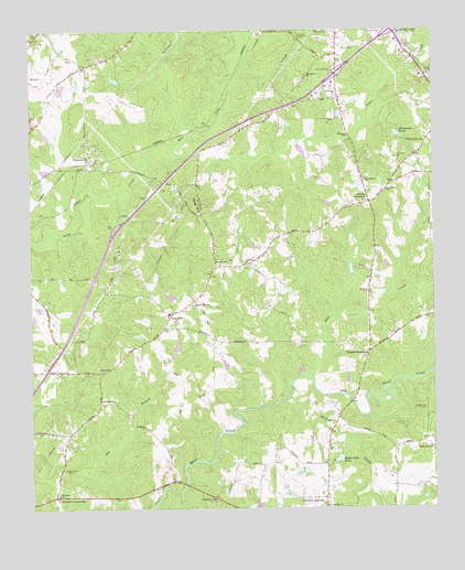
Cannonville, GA USGS Topographic Map
Click on map above to begin viewing in our Map Viewer.

This topographic map contains these locations and features:
Feature Name Type Latitude Longitude GNIS ID View Map
Bartley Road EstatesPopulated PlaceN32.9807°W85.0013°1673173View Map
Baughs CrossroadsPopulated PlaceN32.9160°W85.0199°354484View Map
Bethel CemeteryCemeteryN32.9123°W85.1041°1673175View Map
Bethel ChurchChurchN32.9121°W85.1038°311188View Map
Blue John CreekStreamN32.9687°W85.0813°311549View Map
Bright Star CemeteryCemeteryN32.9010°W85.0024°311798View Map
Bright Star ChurchChurchN32.8904°W85.0010°311801View Map
CannonvillePopulated PlaceN32.9665°W85.1052°312319View Map
Colonial HeightsPopulated PlaceN32.8807°W85.0308°1673185View Map
Cottons CrossroadsPopulated PlaceN32.8782°W85.1177°313011View Map
Davidson ChurchChurchN32.8787°W85.1166°313328View Map
Dickerson DamDamN32.8851°W85.0416°340728View Map
Dickerson LakeReservoirN32.8847°W85.0395°340729View Map
Eagle Club DamDamN32.8879°W85.0291°340730View Map
Eagle Club LakeReservoirN32.8880°W85.0296°313755View Map
Fannin CemeteryCemeteryN32.9951°W85.0274°314078View Map
Federal HillsPopulated PlaceN32.9860°W85.0055°1673196View Map
Georgia State Patrol Troop D Post 2 LagrangeBuildingN32.9877°W85.0007°2734041View Map
Gray HillPopulated PlaceN32.9248°W85.0822°331854View Map
Gray Hill ChurchChurchN32.9282°W85.0738°314800View Map
Gray Hill SchoolSchoolN32.9260°W85.0822°1673208View Map
Grayhill AirportAirportN32.9504°W85.0508°2442679View Map
Hammetts DamDamN32.9729°W85.0110°340722View Map
Hammetts PondReservoirN32.9730°W85.0108°315062View Map
Handleys Store (historical)LocaleN32.9937°W85.0294°1673212View Map
Hogg MountainSummitN32.9535°W85.0735°332003View Map
Hogg MountainPopulated PlaceN32.9587°W85.0791°1673221View Map
Hunts Store (historical)LocaleN32.9765°W85.0274°1673224View Map
Interchange 2CrossingN32.9887°W85.0297°1673225View Map
Interchange 3CrossingN32.9998°W85.0124°1673226View Map
Lebanon CemeteryCemeteryN32.9385°W85.0585°1673235View Map
Lebanon Church (historical)ChurchN32.9110°W85.1033°1673236View Map
Lebanon Progressive Baptist ChurchChurchN32.9393°W85.0583°316721View Map
Linebarker CemeteryCemeteryN32.9582°W85.0141°316909View Map
Macedonia ChurchChurchN32.9882°W85.0388°317550View Map
Maplecreek HillsPopulated PlaceN32.9854°W85.1133°1673246View Map
McCalls CemeteryCemeteryN32.9315°W85.0202°317852View Map
Mount Zion ChurchChurchN32.9398°W85.0641°318990View Map
Mountain Springs ChurchChurchN32.8771°W85.0677°319081View Map
Mud CreekStreamN32.9098°W85.0383°319108View Map
Murphy LakeReservoirN32.9701°W85.0383°340125View Map
Murphy Lake DamDamN32.9701°W85.0383°340124View Map
New Harmony ChurchChurchN32.9029°W85.0988°319327View Map
Oak Grove CemeteryCemeteryN32.9668°W85.0113°319753View Map
Oak Grove ChurchChurchN32.9607°W85.0210°319799View Map
Oak Grove School (historical)SchoolN32.9604°W85.0210°1673254View Map
Old ChimneyPopulated PlaceN32.9373°W85.0205°1673257View Map
Panther CreekStreamN32.9926°W85.0027°320188View Map
Parkway EstatesPopulated PlaceN32.9757°W85.0472°1673258View Map
Pine View School (historical)SchoolN32.9843°W85.0424°1673260View Map
Pineview ChurchChurchN32.9835°W85.0297°320680View Map
Pioneer VillagePopulated PlaceN32.9010°W85.0313°1673264View Map
Plantation ManorPopulated PlaceN32.9421°W85.0485°1673266View Map
Raby WoodsPopulated PlaceN32.9935°W85.1041°1673270View Map
Smiths CrossroadPopulated PlaceN32.9548°W85.0197°326518View Map
Smoke RisePopulated PlaceN32.9598°W85.0880°1673282View Map
South Highland ChurchChurchN32.9993°W85.0102°323255View Map
South Pine RanchettesPopulated PlaceN32.9690°W85.0069°1673284View Map
State BridgeBridgeN32.9026°W85.0260°1673288View Map
Thankful ChurchChurchN32.9643°W85.1038°1673295View Map
Troup County Fire Department Station 1 HeadquartersBuildingN32.9900°W85.0027°2604921View Map
Troup County Fire Department Station 7BuildingN32.9264°W85.0835°2604781View Map
Troup County JailBuildingN32.9883°W85.0031°1673143View Map
Troup County PrisonBuildingN32.9884°W85.0060°2735724View Map
Troup County Sheriff's OfficeBuildingN32.9881°W85.0030°2733887View Map
Union Springs ChurchChurchN32.8751°W85.0333°324585View Map
Union Springs ChurchChurchN32.8757°W85.0347°324586View Map
Webb DamDamN32.9251°W85.1249°340726View Map
Webb LakeReservoirN32.9247°W85.1243°340727View Map
West Point DivisionCivilN32.9152°W85.1193°1936642View Map
West WoodPopulated PlaceN32.9915°W85.0958°1673319View Map
Wildcat CreekStreamN32.9040°W85.0449°325274View Map
Wood ValleyPopulated PlaceN32.9126°W85.0252°1673326View Map
Zachery DamDamN32.9318°W85.0833°340724View Map
Zachery LakeReservoirN32.9303°W85.0814°340725View Map

Note: Coordinates in the location and feature list above are referenced to NAD83 datum.


Copyright (C) 2008-2024 Ryan Niemi / Sunset Dynamics ... All Rights Reserved