TopoQuest Logo
Do you find TopoQuest useful?
Help keep TopoQuest running and adding new maps/features by donating!
Bitcoin:  19c7KJd3qBynnjoSw5npx9KScwjBe4ifkT
Litecoin:  LXs6TkuXGGXo1vDsWCkWVdjQX94eUKd6ui
Home View Maps Find Maps Find Places Resources & Links


Maxville, Montana Topographic Map

USGS Map Title: Maxville, MT
USGS Map MRC: 46113D2
DRG (GeoTIFF) Download: o46113d2.tif


Neighboring USGS Topographic Map Quads:


  Nirling Hill, MT  
46113E3
 

  Hall, MT  
46113E2
 

  Dunkleberg Creek, MT  
46113E1
 

  Henderson Mountain, MT  
46113D3
 

  Maxville, MT  
46113D2
 

  Pikes Peak, MT  
46113D1
 

  Philipsburg, MT  
46113C3
 

  Fred Burr Lake, MT  
46113C2
 

  Pozega Lakes, MT  
46113C1


Map MRC Location:

N47°
W114°
N47°
W113°
H8 H7 H6 H5 H4 H3 H2 H1
G8 G7 G6 G5 G4 G3 G2 G1
F8 F7 F6 F5 F4 F3 F2 F1
E8 E7 E6 E5 E4 E3 E2 E1
D8 D7 D6 D5 D4 D3 D2 D1
C8 C7 C6 C5 C4 C3 C2 C1
B8 B7 B6 B5 B4 B3 B2 B1
A8 A7 A6 A5 A4 A3 A2 A1
N46°
W114°
N46°
W113°

Maxville, MT USGS 1:24K Topographic Map Preview:
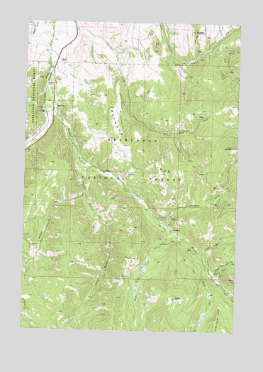
Maxville, MT USGS Topographic Map
Click on map above to begin viewing in our Map Viewer.

This topographic map contains these locations and features:
Feature Name Type Latitude Longitude GNIS ID View Map
08N13W04BAAB01 WellWellN46.4813°W113.2359°816472View Map
08N13W04BDAC01 WellWellN46.4755°W113.2362°816434View Map
08N13W04CAAA01 WellWellN46.4741°W113.2348°816428View Map
08N13W04CADA01 WellWellN46.4721°W113.2348°816417View Map
08N13W09BDBA01 WellWellN46.4630°W113.2378°816383View Map
Achegan MineMineN46.4952°W113.2495°803030View Map
Boulder (historical)LocaleN46.4638°W113.2328°1781860View Map
Boulder CreekStreamN46.4785°W113.2370°780261View Map
Brooklyn MineMineN46.3896°W113.1259°803031View Map
Cominco Phosphate MineMineN46.4855°W113.1501°803081View Map
Copper CreekStreamN46.4038°W113.1448°781646View Map
Copper Creek MineMineN46.3980°W113.1348°803070View Map
Death Road MineMineN46.4044°W113.1253°803091View Map
Douglas MountainSummitN46.4966°W113.1514°782515View Map
Fields (historical)LocaleN46.4994°W113.2231°1781872View Map
Flint School (historical)SchoolN46.4638°W113.2315°1781871View Map
Gird Creek MineMineN46.4866°W113.2134°803076View Map
Gold Hill MineMineN46.4046°W113.1864°784063View Map
Gold Hill MineMineN46.4049°W113.1876°803095View Map
Gold ReefMineN46.3810°W113.1992°794138View Map
Ham GulchValleyN46.4516°W113.2487°784490View Map
Ham Gulch MineMineN46.4527°W113.2467°803109View Map
Hickey HillSummitN46.3885°W113.1603°784814View Map
Little Gold CreekStreamN46.4063°W113.1453°786295View Map
Londonderry MineMineN46.4730°W113.2448°803118View Map
MaxvillePopulated PlaceN46.4646°W113.2342°786949View Map
MaxvilleLocaleN46.4646°W113.2342°1781881View Map
Maxville Census Designated PlaceCensusN46.4760°W113.2355°2583829View Map
Maxville Post Office (historical)Post OfficeN46.4646°W113.2342°1781806View Map
Maywood RidgeRidgeN46.4483°W113.1817°786971View Map
Medhurst Post Office (historical)Post OfficeN46.4166°W113.1676°1781805View Map
Middle Fork Douglas CreekStreamN46.4885°W113.1437°787267View Map
Moonlight MineMineN46.4549°W113.2384°803166View Map
Moonlight MineMineN46.4258°W113.1392°803016View Map
Moonlight MineMineN46.4260°W113.1389°787613View Map
Mount PrincetonSummitN46.4496°W113.1284°789191View Map
NE Section 7 MineMineN46.4874°W113.1467°803131View Map
NE SW Section 17 MineMineN46.4455°W113.2445°803165View Map
New Seattle MineMineN46.4652°W113.2412°803111View Map
Nonpareil MineMineN46.3980°W113.1348°803018View Map
Nonpareil MineMineN46.3991°W113.1384°788053View Map
North Fork Douglas CreekStreamN46.4885°W113.1437°788142View Map
Pierre HillSummitN46.3960°W113.1253°788849View Map
PrincetonPopulated PlaceN46.4169°W113.1656°789189View Map
Princeton GulchValleyN46.4196°W113.1676°789190View Map
Princeton MineMineN46.4116°W113.1617°803161View Map
Princeton Placer MineMineN46.4208°W113.1662°803013View Map
Princeton Post Office (historical)Post OfficeN46.4169°W113.1656°1781800View Map
Princeton School (historical)SchoolN46.4169°W113.1656°1781824View Map
Royal Basin MineMineN46.4271°W113.2337°794137View Map
Royal Basin MineMineN46.4258°W113.2309°803072View Map
Royal Gold CreekStreamN46.3999°W113.1428°789822View Map
Saranac MineMineN46.4144°W113.1689°803094View Map
SE Section 12 MineMineN46.4980°W113.1667°803130View Map
Snow Cap MineMineN46.4877°W113.1570°803129View Map
Snowcap MineMineN46.4444°W113.1545°794162View Map
South Boulder CreekStreamN46.4413°W113.2145°790879View Map
South Fork Douglas CreekStreamN46.4885°W113.1345°790948View Map
SW Section 7 MineMineN46.4996°W113.1564°803128View Map
Swamp Gulch CreekStreamN46.4155°W113.1656°791774View Map
Travonia MineMineN46.4116°W113.1617°803093View Map
Wyman GulchValleyN46.4299°W113.2151°793570View Map

Note: Coordinates in the location and feature list above are referenced to NAD83 datum.


Copyright (C) 2008-2024 Ryan Niemi / Sunset Dynamics ... All Rights Reserved