TopoQuest Logo
Do you find TopoQuest useful?
Help keep TopoQuest running and adding new maps/features by donating!
Bitcoin:  19c7KJd3qBynnjoSw5npx9KScwjBe4ifkT
Litecoin:  LXs6TkuXGGXo1vDsWCkWVdjQX94eUKd6ui
Home View Maps Find Maps Find Places Resources & Links


Orlando, West Virginia Topographic Map

USGS Map Title: Orlando, WV
USGS Map MRC: 38080G5
DRG (GeoTIFF) Download: o38080g5.tif


Neighboring USGS Topographic Map Quads:


  Gilmer, WV  
38080H6
 

  Peterson, WV  
38080H5
 

  Roanoke, WV  
38080H4
 

  Burnsville, WV  
38080G6
 

  Orlando, WV  
38080G5
 

  Walkersville, WV  
38080G4
 

  Sutton, WV  
38080F6
 

  Newville, WV  
38080F5
 

  Hacker Valley, WV  
38080F4


Map MRC Location:

N39°
W81°
N39°
W80°
H8 H7 H6 H5 H4 H3 H2 H1
G8 G7 G6 G5 G4 G3 G2 G1
F8 F7 F6 F5 F4 F3 F2 F1
E8 E7 E6 E5 E4 E3 E2 E1
D8 D7 D6 D5 D4 D3 D2 D1
C8 C7 C6 C5 C4 C3 C2 C1
B8 B7 B6 B5 B4 B3 B2 B1
A8 A7 A6 A5 A4 A3 A2 A1
N38°
W81°
N38°
W80°

Orlando, WV USGS 1:24K Topographic Map Preview:
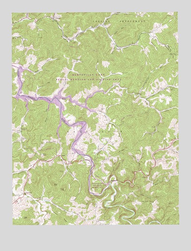
Orlando, WV USGS Topographic Map
Click on map above to begin viewing in our Map Viewer.

This topographic map contains these locations and features:
Feature Name Type Latitude Longitude GNIS ID View Map
Barbecue RunStreamN38.8265°W80.5295°1535208View Map
Barbecue Run School (historical)SchoolN38.8387°W80.5206°1689925View Map
Benny RunStreamN38.8226°W80.5962°1535641View Map
Big RunStreamN38.8120°W80.5876°1535912View Map
Big Run CemeteryCemeteryN38.7815°W80.5856°1535956View Map
Brown CemeteryCemeteryN38.7973°W80.6026°1536405View Map
Buck KnobSummitN38.7918°W80.6023°1536560View Map
BulltownPopulated PlaceN38.7887°W80.5665°1554027View Map
Bulltown BridgeBridgeN38.7835°W80.5652°2635306View Map
Burnsville LakeReservoirN38.8251°W80.6070°1560649View Map
Burnsville Lake DamDamN38.8401°W80.6181°1560648View Map
Burnsville Lake Wildlife Management AreaParkN38.8348°W80.5790°1727239View Map
Casto CemeteryCemeteryN38.8584°W80.5776°1537099View Map
Cedar KnobSummitN38.7740°W80.5940°1554094View Map
ChapmanPopulated PlaceN38.8543°W80.5440°1554108View Map
Chop ForkStreamN38.8284°W80.5601°1537323View Map
Chop Fork CemeteryCemeteryN38.8393°W80.5426°1537324View Map
Clover ForkStreamN38.8704°W80.5934°1537424View Map
Clover Fork ChurchChurchN38.8687°W80.5562°1537425View Map
Clover Fork School (historical)SchoolN38.8690°W80.5556°1689942View Map
Curry RidgeRidgeN38.7907°W80.5498°1537932View Map
DutchPopulated PlaceN38.8051°W80.6181°1549665View Map
Elliott RunStreamN38.7512°W80.5145°1538668View Map
Falls MillPopulated PlaceN38.7737°W80.5498°1554438View Map
Falls RunStreamN38.7745°W80.5518°1538882View Map
Falls Run ChurchChurchN38.7782°W80.5234°1538885View Map
Fleming CemeteryCemeteryN38.8181°W80.5587°1539076View Map
Flesher RunStreamN38.8248°W80.5884°1539083View Map
Hemp Patch RunStreamN38.7740°W80.5340°1540138View Map
Highwood CemeteryCemeteryN38.7651°W80.5625°2574003View Map
Hog KnobSummitN38.7545°W80.6137°1540350View Map
Kanawha ChapelChurchN38.8445°W80.6184°1549550View Map
Keener RidgeRidgeN38.7543°W80.5890°1541103View Map
Keith RunStreamN38.7815°W80.5304°1541120View Map
Kennedy RunStreamN38.8362°W80.5568°1541153View Map
Kings KnobSummitN38.7709°W80.5856°1541223View Map
KnawlPopulated PlaceN38.8268°W80.5293°1549775View Map
Knawl CreekStreamN38.8245°W80.5909°1541261View Map
Knawl Creek CemeteryCemeteryN38.8293°W80.5165°1541262View Map
Knawl Creek ChurchChurchN38.8290°W80.5029°1541263View Map
Knawl Creek School (historical)SchoolN38.8162°W80.5134°1689928View Map
Knawl School (historical)SchoolN38.8276°W80.5890°1689929View Map
Laurel RunStreamN38.7793°W80.5484°1541501View Map
Left Fork Falls RunStreamN38.7784°W80.5226°1541655View Map
Left Fork Knawl CreekStreamN38.8240°W80.5256°1541672View Map
Little Knawl CreekStreamN38.8190°W80.5701°1542137View Map
Little Knawl Creek School (historical)SchoolN38.8154°W80.5543°1689930View Map
Long RunStreamN38.8257°W80.6137°1549553View Map
Long Run ChurchChurchN38.8012°W80.6173°1542424View Map
Long Run School (historical)SchoolN38.8065°W80.6181°1542426View Map
Lower Big Run School (historical)SchoolN38.7948°W80.5873°1689932View Map
McCauley Run School (historical)SchoolN38.8609°W80.6181°1689933View Map
Meadow RunStreamN38.8668°W80.5559°1543075View Map
Middle RunStreamN38.8601°W80.5518°1543214View Map
Millstone RunStreamN38.7870°W80.5645°1543425View Map
Mount Harmony ChurchChurchN38.7526°W80.5609°1543645View Map
Mount Hope ChurchChurchN38.8501°W80.5026°1543660View Map
Mudlick School (historical)SchoolN38.8287°W80.5590°1689934View Map
Mulberry RunStreamN38.8601°W80.5204°1543983View Map
NapierPopulated PlaceN38.7909°W80.5887°1549844View Map
Napier Post OfficePost OfficeN38.7877°W80.6024°1727284View Map
Northern DistrictCivilN38.7963°W80.6231°1928330View Map
Olive ChapelChurchN38.8345°W80.6173°1544396View Map
OrlandoPopulated PlaceN38.8712°W80.5937°1549863View Map
Orlando Post OfficePost OfficeN38.8713°W80.5927°1728650View Map
Peyton Riffle School (historical)SchoolN38.8279°W80.6170°1689935View Map
Pickles ForkStreamN38.7645°W80.6084°1544801View Map
Pigeonroost ForkStreamN38.8170°W80.5151°1544830View Map
Pleasant HillSummitN38.7695°W80.5376°1544991View Map
Pleasant Hill ChurchChurchN38.7634°W80.5229°1544998View Map
Pleasant Hill School (historical)SchoolN38.7629°W80.5204°1689936View Map
Posey RunStreamN38.8707°W80.6134°1545171View Map
Ratcliff CemeteryCemeteryN38.8176°W80.6118°1545417View Map
Riffle CemeteryCemeteryN38.8476°W80.5943°1545589View Map
Riffle RunStreamN38.8415°W80.6154°1545592View Map
Riffle Run Recreation AreaParkN38.8418°W80.6123°1727288View Map
Riffle School (historical)SchoolN38.8423°W80.6134°1689937View Map
Riffle School (historical)SchoolN38.8404°W80.6106°1545594View Map
Road RunStreamN38.8687°W80.6073°1545827View Map
Rock RunStreamN38.8551°W80.5459°1545920View Map
Saint Michaels ChurchChurchN38.8473°W80.5768°1546265View Map
Saltlick BridgeLocaleN38.7687°W80.6159°1546313View Map
Saltlick Creek Structure Number Four DamDamN38.7584°W80.6165°1557397View Map
Saltlick Creek Structure Number Six DamDamN38.7651°W80.6015°1557398View Map
Singleton School (historical)SchoolN38.7754°W80.6145°1689938View Map
Skinner SpringSpringN38.8745°W80.5923°1677969View Map
Spruce ForkStreamN38.7990°W80.5895°1547236View Map
Threelick RunStreamN38.8748°W80.5906°1548074View Map
Tichnel ChurchChurchN38.7645°W80.6065°1548087View Map
Triplets RunStreamN38.8237°W80.6062°1548275View Map
Tyler RunStreamN38.7679°W80.5640°1548450View Map
Upper Big Run School (historical)SchoolN38.7609°W80.5820°1689940View Map
Upper Clover Fork School (historical)SchoolN38.8620°W80.5209°1689952View Map
Warner School (historical)SchoolN38.8320°W80.5048°1689941View Map
Wildcat RunStreamN38.7948°W80.5076°1549139View Map
Wine GapGapN38.7882°W80.6040°1549246View Map

Note: Coordinates in the location and feature list above are referenced to NAD83 datum.


Copyright (C) 2008-2024 Ryan Niemi / Sunset Dynamics ... All Rights Reserved