TopoQuest Logo
Do you find TopoQuest useful?
Help keep TopoQuest running and adding new maps/features by donating!
Bitcoin:  19c7KJd3qBynnjoSw5npx9KScwjBe4ifkT
Litecoin:  LXs6TkuXGGXo1vDsWCkWVdjQX94eUKd6ui
Home View Maps Find Maps Find Places Resources & Links


Newville, West Virginia Topographic Map

USGS Map Title: Newville, WV
USGS Map MRC: 38080F5
DRG (GeoTIFF) Download: o38080f5.tif


Neighboring USGS Topographic Map Quads:


  Burnsville, WV  
38080G6
 

  Orlando, WV  
38080G5
 

  Walkersville, WV  
38080G4
 

  Sutton, WV  
38080F6
 

  Newville, WV  
38080F5
 

  Hacker Valley, WV  
38080F4
 

  Little Birch, WV  
38080E6
 

  Erbacon, WV  
38080E5
 

  Diana, WV  
38080E4


Map MRC Location:

N39°
W81°
N39°
W80°
H8 H7 H6 H5 H4 H3 H2 H1
G8 G7 G6 G5 G4 G3 G2 G1
F8 F7 F6 F5 F4 F3 F2 F1
E8 E7 E6 E5 E4 E3 E2 E1
D8 D7 D6 D5 D4 D3 D2 D1
C8 C7 C6 C5 C4 C3 C2 C1
B8 B7 B6 B5 B4 B3 B2 B1
A8 A7 A6 A5 A4 A3 A2 A1
N38°
W81°
N38°
W80°

Newville, WV USGS 1:24K Topographic Map Preview:
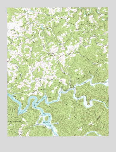
Newville, WV USGS Topographic Map
Click on map above to begin viewing in our Map Viewer.

This topographic map contains these locations and features:
Feature Name Type Latitude Longitude GNIS ID View Map
Bakers RunStreamN38.6373°W80.5809°1535159View Map
Bakers RunPopulated PlaceN38.6351°W80.5929°1553780View Map
Bakers Run Camping AreaLocaleN38.6351°W80.5751°1535160View Map
Bee RunStreamN38.7215°W80.6109°1535495View Map
Belknap HollowValleyN38.6701°W80.5590°1535595View Map
Bens RunStreamN38.6643°W80.6190°1535646View Map
Brock RunStreamN38.6645°W80.5784°1536381View Map
Brock Run Camping AreaLocaleN38.6637°W80.5765°1536382View Map
Browns RunStreamN38.6562°W80.5751°1536442View Map
Cabin RunStreamN38.6532°W80.5270°1536832View Map
CaressPopulated PlaceN38.7045°W80.5493°1549620View Map
Carpenter ForkStreamN38.7220°W80.5937°1537055View Map
Coplin RunStreamN38.7462°W80.5134°1537673View Map
CorleyPopulated PlaceN38.7368°W80.5995°1554191View Map
Dry ForkStreamN38.6368°W80.5704°1538352View Map
Eastern DistrictCivilN38.6583°W80.6026°1928262View Map
England RunStreamN38.7429°W80.5273°1538714View Map
Fall RunStreamN38.6548°W80.5231°1538844View Map
Fisher CemeteryCemeteryN38.7284°W80.5290°1538990View Map
Gerald R Freeman BridgeBridgeN38.6724°W80.5417°2635303View Map
Gibson CemeteryCemeteryN38.7334°W80.5154°1539384View Map
GillespiePopulated PlaceN38.6637°W80.6179°1549702View Map
GregoryPopulated PlaceN38.7437°W80.5276°1549718View Map
Gulf RunStreamN38.7495°W80.5362°1539784View Map
Hamner CemeteryCemeteryN38.7309°W80.5854°1539888View Map
Harper RidgeRidgeN38.7307°W80.5395°1539996View Map
High KnobSummitN38.7059°W80.5726°1554703View Map
High Knob ChurchChurchN38.7054°W80.5743°1540248View Map
High Knob Church CemeteryCemeteryN38.7055°W80.5741°2724811View Map
High Knob School (historical)SchoolN38.7040°W80.5723°1540249View Map
HollyPopulated PlaceN38.6704°W80.5479°1549747View Map
Holly Junction (historical)LocaleN38.6584°W80.5998°1727333View Map
Holly RiverStreamN38.6534°W80.5912°1540396View Map
Howell HollowValleyN38.6765°W80.5387°1540532View Map
Hughes ForkStreamN38.7345°W80.5943°1540569View Map
Kanawha RunStreamN38.6704°W80.5479°1541067View Map
Kanawha Run Camping AreaLocaleN38.6693°W80.5579°1541069View Map
Kniceley CemeteryCemeteryN38.7151°W80.5131°1541264View Map
Kraft CemeteryCemeteryN38.7240°W80.5056°1541291View Map
Laurelpatch RunStreamN38.6793°W80.5229°1541551View Map
Left Fork Holly RiverStreamN38.6709°W80.5429°1541664View Map
Long ForkStreamN38.6948°W80.5195°1542372View Map
MarpletonPopulated PlaceN38.6776°W80.5037°1549808View Map
McCoy RunStreamN38.7357°W80.5259°1542969View Map
Middle RidgeRidgeN38.7190°W80.5826°1543209View Map
Mill CreekStreamN38.6270°W80.5665°1543320View Map
MilroyPopulated PlaceN38.7270°W80.5006°1555132View Map
Morrison ChurchChurchN38.6995°W80.6220°1543586View Map
Morrison RidgeRidgeN38.7045°W80.6176°1543589View Map
Morrison United Methodist Church CemeteryCemeteryN38.6994°W80.6220°2586214View Map
Mount Hebron CemeteryCemeteryN38.7029°W80.5589°2586216View Map
Mount Hebron ChurchChurchN38.7026°W80.5601°1543647View Map
Mount Nebo ChurchChurchN38.7201°W80.5145°1543685View Map
NewvillePopulated PlaceN38.6787°W80.5906°1544163View Map
Newville CemeteryCemeteryN38.6890°W80.5943°1544164View Map
Oldlick CreekStreamN38.6751°W80.5054°1544390View Map
Oldlick RunStreamN38.6462°W80.6115°1544391View Map
PalmerPopulated PlaceN38.6576°W80.5893°1555296View Map
Peebles RunStreamN38.6615°W80.5615°1544688View Map
Rader RunStreamN38.6490°W80.6018°1545377View Map
Right Fork Flatwoods RunStreamN38.6709°W80.6248°1545640View Map
Right Fork Holly RiverStreamN38.6709°W80.5431°1545650View Map
Right Fork Saltlick CreekStreamN38.7179°W80.6193°1545694View Map
Robinson RunStreamN38.6615°W80.5381°1545872View Map
Saltlick Creek Structure Number Eight DamDamN38.7334°W80.5831°1557400View Map
Saltlick Creek Structure Number Seven DamDamN38.7418°W80.5915°1557399View Map
Short RunStreamN38.7418°W80.5059°1546738View Map
Spruce ForkStreamN38.7465°W80.6001°1547235View Map
State of West VirginiaCivilN38.6426°W80.6137°1779805View Map
Stone RunStreamN38.7218°W80.6098°1547460View Map
Stone Run CemeteryCemeteryN38.7323°W80.6206°2586164View Map
Stone Run ChurchChurchN38.7282°W80.6165°1547461View Map
Stonecoal RunStreamN38.7365°W80.5048°1547474View Map
Stonecoal School (historical)SchoolN38.7334°W80.5145°1547477View Map
Sulphur RunStreamN38.7232°W80.5679°1547714View Map
Sutton LakeReservoirN38.6564°W80.5911°1547782View Map
Tar Fall RunStreamN38.6573°W80.6123°1547903View Map
Ware CemeteryCemeteryN38.7031°W80.5668°1548797View Map
Ware MountainSummitN38.6298°W80.5379°1555919View Map
Wilson ForkStreamN38.6815°W80.5201°1549220View Map

Note: Coordinates in the location and feature list above are referenced to NAD83 datum.


Copyright (C) 2008-2025 Ryan Niemi / Sunset Dynamics ... All Rights Reserved