TopoQuest Logo
Do you find TopoQuest useful?
Help keep TopoQuest running and adding new maps/features by donating!
Bitcoin:  19c7KJd3qBynnjoSw5npx9KScwjBe4ifkT
Litecoin:  LXs6TkuXGGXo1vDsWCkWVdjQX94eUKd6ui
Home View Maps Find Maps Find Places Resources & Links


Gilmer, West Virginia Topographic Map

USGS Map Title: Gilmer, WV
USGS Map MRC: 38080H6
DRG (GeoTIFF) Download: o38080h6.tif


Neighboring USGS Topographic Map Quads:


  Auburn, WV  
39080A7
 

  Vadis, WV  
39080A6
 

  Camden, WV  
39080A5
 

  Glenville, WV  
38080H7
 

  Gilmer, WV  
38080H6
 

  Peterson, WV  
38080H5
 

  Cedarville, WV  
38080G7
 

  Burnsville, WV  
38080G6
 

  Orlando, WV  
38080G5


Map MRC Location:

N39°
W81°
N39°
W80°
H8 H7 H6 H5 H4 H3 H2 H1
G8 G7 G6 G5 G4 G3 G2 G1
F8 F7 F6 F5 F4 F3 F2 F1
E8 E7 E6 E5 E4 E3 E2 E1
D8 D7 D6 D5 D4 D3 D2 D1
C8 C7 C6 C5 C4 C3 C2 C1
B8 B7 B6 B5 B4 B3 B2 B1
A8 A7 A6 A5 A4 A3 A2 A1
N38°
W81°
N38°
W80°

Gilmer, WV USGS 1:24K Topographic Map Preview:
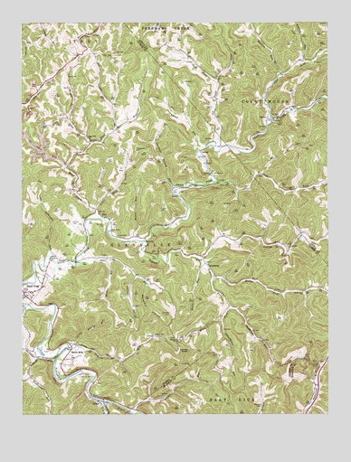
Gilmer, WV USGS Topographic Map
Click on map above to begin viewing in our Map Viewer.

This topographic map contains these locations and features:
Feature Name Type Latitude Longitude GNIS ID View Map
Barker ChurchChurchN38.8990°W80.6870°1535227View Map
Barrett CemeteryCemeteryN38.8779°W80.6526°1535283View Map
BlackburnPopulated PlaceN38.9231°W80.6751°1553915View Map
Boilon CemeteryCemeteryN38.9520°W80.6718°1536203View Map
Butchers ForkStreamN38.9493°W80.6707°1536797View Map
Canfield CemeteryCemeteryN38.9073°W80.6898°1537001View Map
Chestnut Bottom RunStreamN38.9473°W80.6882°1537263View Map
Collins RunStreamN38.9193°W80.7040°1537532View Map
Conner School (historical)SchoolN38.9690°W80.7112°1689914View Map
Conrad CemeteryCemeteryN38.8870°W80.7262°1537584View Map
Conrad CemeteryCemeteryN38.9365°W80.7295°1537585View Map
Copen RunStreamN38.8798°W80.7176°1537666View Map
CopleyPopulated PlaceN38.9695°W80.6476°1549640View Map
Cove LickStreamN38.9687°W80.6487°1537727View Map
Cove Run School (historical)SchoolN38.9884°W80.6301°1689943View Map
DonlanPopulated PlaceN38.9587°W80.6770°1549658View Map
Dumpling Run School (historical)SchoolN38.8804°W80.6315°1689926View Map
Duskcamp RunStreamN38.8945°W80.7432°1538460View Map
Dyer CemeteryCemeteryN38.9320°W80.7109°1538483View Map
Edmiston ChurchChurchN38.9520°W80.6726°1538558View Map
EllisPopulated PlaceN38.9379°W80.7165°1554389View Map
Ellis CreekStreamN38.9379°W80.7190°1538675View Map
Ellis Grove ChurchChurchN38.9340°W80.7137°1538679View Map
Fork Ellis CreekStreamN38.9670°W80.7112°1539133View Map
GilmerPopulated PlaceN38.8793°W80.7168°1554557View Map
Gilmer County Volunteer Fire Department Sand Fork StationBuildingN38.9142°W80.7484°2577787View Map
Gilmer Post OfficePost OfficeN38.8793°W80.7154°1689675View Map
Glenville DistrictCivilN38.9277°W80.7279°1928274View Map
Hacker RunStreamN38.9245°W80.7162°1539815View Map
Heaters ForkStreamN38.8998°W80.6848°1540108View Map
Heaters Fork School (historical)SchoolN38.9051°W80.6690°1689915View Map
Hiney ChurchChurchN38.9676°W80.7415°1540312View Map
Indian ForkStreamN38.9298°W80.6993°1540685View Map
Jakes RunStreamN38.9543°W80.7318°1540804View Map
Jerseywood RunStreamN38.9593°W80.6770°1540879View Map
Jerseywood School (historical)SchoolN38.9618°W80.6790°1689916View Map
Joes RunStreamN38.9234°W80.7270°1540938View Map
Joes Run School (historical)SchoolN38.9231°W80.7090°1689917View Map
Keith CemeteryCemeteryN38.9562°W80.6984°1541117View Map
Left Fork Old Field ForkStreamN38.9818°W80.6701°1541699View Map
Lick RunStreamN38.9098°W80.7468°1541939View Map
Little Ellis CreekStreamN38.9401°W80.7198°1542095View Map
Little Sliding RunStreamN38.8970°W80.7293°1542222View Map
Locust KnobSummitN38.8954°W80.6823°1542300View Map
Longshoal RunStreamN38.8757°W80.7054°1542440View Map
Longshoal School (historical)SchoolN38.8801°W80.6984°1689931View Map
Low Gap School (historical)SchoolN38.8951°W80.7448°1689918View Map
Marshall HollowValleyN38.9168°W80.6993°1542795View Map
McHenry CemeteryCemeteryN38.9354°W80.7165°1543011View Map
Messenger CemeteryCemeteryN38.9598°W80.7034°1543138View Map
Mick CemeteryCemeteryN38.8915°W80.6318°1543155View Map
Middle Ellis CreekStreamN38.9615°W80.7212°1543166View Map
Middle Ellis School (historical)SchoolN38.9620°W80.7212°1689919View Map
Mikes RunStreamN38.9306°W80.7045°1543245View Map
Moore RunStreamN38.9231°W80.6768°1543517View Map
Old Field ForkStreamN38.9598°W80.6693°1544352View Map
Old Field Fork CemeteryCemeteryN38.9829°W80.6709°1544353View Map
Old Field School (historical)SchoolN38.9812°W80.6698°1689947View Map
Raccoon RunStreamN38.9837°W80.6445°1545366View Map
Right Fork Duskcamp RunStreamN38.8873°W80.7470°1545637View Map
Rockriffle RunStreamN38.9254°W80.7382°1545999View Map
Rocky ForkStreamN38.9193°W80.6720°1546020View Map
Rocky Fork ChurchChurchN38.9140°W80.6354°1546022View Map
Rocky Fork School (historical)SchoolN38.9143°W80.6345°1689920View Map
Rogers CemeteryCemeteryN38.9406°W80.6934°1546042View Map
Rudkin School (historical)SchoolN38.9034°W80.6901°1689921View Map
Sand ForkPopulated PlaceN38.9140°W80.7498°1546345View Map
Sand Fork CemeteryCemeteryN38.9161°W80.7477°2574009View Map
Sand Fork Elementary SchoolSchoolN38.9139°W80.7458°1689730View Map
Sand Fork School (historical)SchoolN38.9479°W80.6762°1689922View Map
Schoolhouse RunStreamN38.9054°W80.6682°1546503View Map
Sliding RunStreamN38.8965°W80.7312°1546945View Map
Slidinghill School (historical)SchoolN38.8959°W80.7232°1689923View Map
Snyder CemeteryCemeteryN38.9006°W80.6962°1547044View Map
Stonepot RunStreamN38.9870°W80.6354°1547485View Map
Stouts MillsPopulated PlaceN38.8951°W80.7304°1555724View Map
Stouts Mills Post OfficePost OfficeN38.8965°W80.7354°1689740View Map
Tomblin RunStreamN38.9093°W80.6651°1550062View Map
Town of Sand ForkCivilN38.9154°W80.7477°2391402View Map
Tumbling CemeteryCemeteryN38.9087°W80.6593°1548316View Map
Tumbling Run School (historical)SchoolN38.8979°W80.6509°1689924View Map
Upper Ellis ChurchChurchN38.9634°W80.7234°1548517View Map

Note: Coordinates in the location and feature list above are referenced to NAD83 datum.


Copyright (C) 2008-2025 Ryan Niemi / Sunset Dynamics ... All Rights Reserved