TopoQuest Logo
Do you find TopoQuest useful?
Help keep TopoQuest running and adding new maps/features by donating!
Bitcoin:  19c7KJd3qBynnjoSw5npx9KScwjBe4ifkT
Litecoin:  LXs6TkuXGGXo1vDsWCkWVdjQX94eUKd6ui
Home View Maps Find Maps Find Places Resources & Links


Sutton, West Virginia Topographic Map

USGS Map Title: Sutton, WV
USGS Map MRC: 38080F6
DRG (GeoTIFF) Download: o38080f6.tif


Neighboring USGS Topographic Map Quads:


  Cedarville, WV  
38080G7
 

  Burnsville, WV  
38080G6
 

  Orlando, WV  
38080G5
 

  Gassaway, WV  
38080F7
 

  Sutton, WV  
38080F6
 

  Newville, WV  
38080F5
 

  Herold, WV  
38080E7
 

  Little Birch, WV  
38080E6
 

  Erbacon, WV  
38080E5


Map MRC Location:

N39°
W81°
N39°
W80°
H8 H7 H6 H5 H4 H3 H2 H1
G8 G7 G6 G5 G4 G3 G2 G1
F8 F7 F6 F5 F4 F3 F2 F1
E8 E7 E6 E5 E4 E3 E2 E1
D8 D7 D6 D5 D4 D3 D2 D1
C8 C7 C6 C5 C4 C3 C2 C1
B8 B7 B6 B5 B4 B3 B2 B1
A8 A7 A6 A5 A4 A3 A2 A1
N38°
W81°
N38°
W80°

Sutton, WV USGS 1:24K Topographic Map Preview:
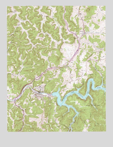
Sutton, WV USGS Topographic Map
Click on map above to begin viewing in our Map Viewer.

This topographic map contains these locations and features:
Feature Name Type Latitude Longitude GNIS ID View Map
Bee HollowValleyN38.6420°W80.6595°1535487View Map
Bee RunStreamN38.6643°W80.6859°1535494View Map
Bee Run CampsiteLocaleN38.6670°W80.6784°1535509View Map
Bee Run Picnic AreaLocaleN38.6554°W80.6812°1535510View Map
Bee Run Recreation AreaParkN38.6662°W80.6782°1727303View Map
Berry ChapelChurchN38.7457°W80.6306°1535664View Map
Berry SidingLocaleN38.7418°W80.6587°1535671View Map
BisonPopulated PlaceN38.6554°W80.7418°1549597View Map
Braxton CountyCivilN38.6999°W80.7193°1550010View Map
Braxton County AirportAirportN38.6851°W80.6513°1558850View Map
Braxton County CemeteryCemeteryN38.6774°W80.6596°2574000View Map
Braxton County CourthouseBuildingN38.6643°W80.7087°1727307View Map
Braxton County Emergency AmbulanceBuildingN38.6962°W80.6572°2775506View Map
Braxton County Emergency Ambulance Service AuthorityBuildingN38.6645°W80.7063°2581081View Map
Braxton County High SchoolSchoolN38.6959°W80.6671°1727308View Map
Braxton County Memorial HospitalHospitalN38.6610°W80.7485°2026667View Map
Braxton County Middle SchoolSchoolN38.6948°W80.6634°1727309View Map
Braxton County Sheriff's OfficeBuildingN38.6641°W80.7082°2727878View Map
Brush ForkStreamN38.6876°W80.6954°1536467View Map
Buckeye CreekStreamN38.6612°W80.6976°1536585View Map
Buffalo CreekStreamN38.6562°W80.7432°1536633View Map
Buffalo Creek BridgeBridgeN38.6509°W80.7378°2635302View Map
Bug Ridge ChurchChurchN38.6301°W80.6851°1536673View Map
Camden Hill CemeteryCemeteryN38.6829°W80.6873°1536878View Map
Canoe RunStreamN38.6645°W80.6259°1537011View Map
Central Regional JailBuildingN38.6975°W80.6573°2634768View Map
Cunningham ForkStreamN38.6326°W80.7279°1537913View Map
Cutlip CemeteryCemeteryN38.6879°W80.7326°1537946View Map
Cutlips ForkStreamN38.6818°W80.7362°1537948View Map
Eakle ChurchChurchN38.6676°W80.7273°1538492View Map
Earls Siding (historical)LocaleN38.6834°W80.7009°1727321View Map
Elk River Wildlife Management AreaParkN38.6382°W80.6318°1538634View Map
Ellison CemeteryCemeteryN38.6548°W80.6906°1538683View Map
FairbanksPopulated PlaceN38.7268°W80.6823°1554427View Map
Fisher CemeteryCemeteryN38.7068°W80.6725°2586389View Map
Fisher KnobSummitN38.7176°W80.6657°1554458View Map
FlatwoodsPopulated PlaceN38.7232°W80.6498°1539070View Map
Flatwoods Community Volunteer Fire DepartmentBuildingN38.7263°W80.6547°2577766View Map
Flatwoods Elementary SchoolSchoolN38.7203°W80.6551°1727323View Map
Flatwoods Factory Outlet StoresLocaleN38.7026°W80.6665°2647142View Map
Flatwoods Police DepartmentBuildingN38.7196°W80.6552°2727879View Map
Flatwoods Post OfficePost OfficeN38.7217°W80.6530°1727324View Map
Flatwoods RunStreamN38.6698°W80.6306°1539072View Map
Frame CemeteryCemeteryN38.6490°W80.7412°1539216View Map
Frame ChapelChurchN38.6504°W80.7334°1539217View Map
Givens ForkStreamN38.6332°W80.6373°1539417View Map
Granny CreekStreamN38.6679°W80.7184°1539584View Map
Granny Creek ChurchChurchN38.6765°W80.7134°1539585View Map
Hopkins Station (historical)LocaleN38.7057°W80.6320°1727339View Map
Huffman Mill (historical)LocaleN38.6626°W80.7104°1727340View Map
Interchange 62CrossingN38.6582°W80.7401°1727346View Map
Interchange 67CrossingN38.7032°W80.6629°1727347View Map
Laurel ForkStreamN38.6898°W80.6754°1541447View Map
Laurel ForkPopulated PlaceN38.6893°W80.6748°1554917View Map
Left Fork Wolf CreekStreamN38.6293°W80.6704°1541749View Map
LloydsvillePopulated PlaceN38.7395°W80.7034°1554979View Map
Lower Flatwoods RunStreamN38.6645°W80.6607°1542542View Map
Loyd Chapel Methodist Episcopal ChurchChurchN38.7382°W80.7032°1727358View Map
McNuttPopulated PlaceN38.6951°W80.6693°1555089View Map
Morton Family CemeteryCemeteryN38.6534°W80.6588°2586282View Map
Moss RunStreamN38.7348°W80.7334°1543599View Map
Mountain Lakes AmphitheatreBuildingN38.6960°W80.6630°2725511View Map
Old Woman RunStreamN38.6634°W80.7034°1544376View Map
PembrokePopulated PlaceN38.7248°W80.7404°1555322View Map
Plank RunStreamN38.7312°W80.7320°1544969View Map
Pleasant Dale ChurchChurchN38.7443°W80.7415°1544979View Map
Red Buck ForkStreamN38.6487°W80.6720°1545447View Map
RiffleLocaleN38.7443°W80.7407°1545588View Map
Riffle Post OfficePost OfficeN38.7440°W80.7415°1727370View Map
Rocky Dale ChurchChurchN38.6879°W80.7318°1546012View Map
Ross ForkStreamN38.7073°W80.6351°1546092View Map
Shaver CemeteryCemeteryN38.7156°W80.6868°1546630View Map
Skidmore RunStreamN38.6637°W80.7123°1546861View Map
Slide RunStreamN38.6434°W80.6595°1546943View Map
Stony CreekStreamN38.6618°W80.6468°1547494View Map
Sunrise ChurchChurchN38.7157°W80.6809°1547759View Map
SuttonPopulated PlaceN38.6645°W80.7098°1555762View Map
Sutton CemeteryCemeteryN38.7118°W80.6525°2586388View Map
Sutton CemeteryCemeteryN38.6685°W80.7094°2586143View Map
Sutton DamDamN38.6619°W80.6930°1557395View Map
Sutton Downtown Historic DistrictParkN38.6645°W80.7084°1727379View Map
Sutton Elementary SchoolSchoolN38.6672°W80.7074°1727380View Map
Sutton Police DepartmentBuildingN38.6641°W80.7079°2727876View Map
Sutton Post OfficePost OfficeN38.6637°W80.7081°1727381View Map
Sutton Public LibraryBuildingN38.6641°W80.7068°2727195View Map
Sutton Truss BridgeBridgeN38.6632°W80.7100°2635305View Map
Sutton Volunteer Fire DepartmentBuildingN38.6646°W80.7077°2577717View Map
Sutton/Gassaway BridgeBridgeN38.6565°W80.7400°2635300View Map
Thrash (historical)Populated PlaceN38.6293°W80.6401°1727384View Map
Town of FlatwoodsCivilN38.7186°W80.6540°2390184View Map
Town of SuttonCivilN38.6663°W80.7115°2391435View Map
Wane ForkStreamN38.6887°W80.7290°1548780View Map
WCKA-FM (Sutton)TowerN38.6532°W80.7193°1559845View Map
West Virginia State Police Troop 3 - Sutton DetachmentBuildingN38.6983°W80.6560°2727877View Map
Wolf CreekStreamN38.6523°W80.6779°1549269View Map
WSGB-AM (Sutton)TowerN38.6532°W80.7193°1559748View Map

Note: Coordinates in the location and feature list above are referenced to NAD83 datum.


Copyright (C) 2008-2024 Ryan Niemi / Sunset Dynamics ... All Rights Reserved