TopoQuest Logo
Do you find TopoQuest useful?
Help keep TopoQuest running and adding new maps/features by donating!
Bitcoin:  19c7KJd3qBynnjoSw5npx9KScwjBe4ifkT
Litecoin:  LXs6TkuXGGXo1vDsWCkWVdjQX94eUKd6ui
Home View Maps Find Maps Find Places Resources & Links


Lime Ridge, Wisconsin Topographic Map

USGS Map Title: Lime Ridge, WI
USGS Map MRC: 43090D2
DRG (GeoTIFF) Download: o43090d2.tif


Neighboring USGS Topographic Map Quads:


  Valton, WI  
43090E3
 

  La Valle, WI  
43090E2
 

  Reedsburg West, WI  
43090E1
 

  Rockbridge, WI  
43090D3
 

  Lime Ridge, WI  
43090D2
 

  Loganville, WI  
43090D1
 

  Sextonville, WI  
43090C3
 

  Bear Valley, WI  
43090C2
 

  Plain, WI  
43090C1


Map MRC Location:

N44°
W91°
N44°
W90°
H8 H7 H6 H5 H4 H3 H2 H1
G8 G7 G6 G5 G4 G3 G2 G1
F8 F7 F6 F5 F4 F3 F2 F1
E8 E7 E6 E5 E4 E3 E2 E1
D8 D7 D6 D5 D4 D3 D2 D1
C8 C7 C6 C5 C4 C3 C2 C1
B8 B7 B6 B5 B4 B3 B2 B1
A8 A7 A6 A5 A4 A3 A2 A1
N43°
W91°
N43°
W90°

Lime Ridge, WI USGS 1:24K Topographic Map Preview:
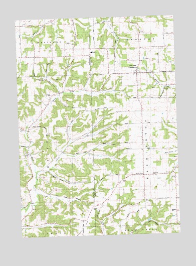
Lime Ridge, WI USGS Topographic Map
Click on map above to begin viewing in our Map Viewer.

This topographic map contains these locations and features:
Feature Name Type Latitude Longitude GNIS ID View Map
Big Willow CemeteryCemeteryN43.4555°W90.2232°1561784View Map
Big Willow Creek Stock FarmLocaleN43.4480°W90.2254°1958612View Map
Blakeslee CemeteryCemeteryN43.3880°W90.1304°1561916View Map
Block School (historical)SchoolN43.4780°W90.2176°1561922View Map
Blue Silo Stock FarmLocaleN43.4430°W90.2443°1958613View Map
Butternut School (historical)SchoolN43.3905°W90.2415°1562486View Map
Concord CemeteryCemeteryN43.4650°W90.2282°1834364View Map
Concord Church (historical)ChurchN43.4655°W90.2273°1563311View Map
Eiffmeyer CemeteryCemeteryN43.4072°W90.1265°1564468View Map
Elm Grove School (historical)SchoolN43.4969°W90.2265°1564563View Map
Fairview Grain and Hop FarmLocaleN43.4344°W90.2265°1957366View Map
Far View FarmLocaleN43.3928°W90.2082°1957367View Map
Harris School (historical)SchoolN43.4522°W90.1471°1566088View Map
Larch Fruit FarmLocaleN43.4800°W90.2357°1957379View Map
Lime RidgePopulated PlaceN43.4678°W90.1548°1568058View Map
Lost HollowValleyN43.4000°W90.2360°1568654View Map
LoydPopulated PlaceN43.4230°W90.2429°1568775View Map
Loyd CemeteryCemeteryN43.4244°W90.2454°1834385View Map
Maple Grove Stock FarmLocaleN43.3833°W90.2340°1957545View Map
Meyers School (historical)SchoolN43.3950°W90.1276°1569396View Map
Oakwood Dairy FarmLocaleN43.4361°W90.2140°1957389View Map
Pine Crest SchoolSchoolN43.4097°W90.1448°1846892View Map
Plain View School (historical)SchoolN43.3933°W90.1871°1571575View Map
Plainview Dairy and Grain FarmLocaleN43.3853°W90.2076°1957395View Map
Pleasant Valley Dairy FarmLocaleN43.4158°W90.2037°1957402View Map
Robin HollowValleyN43.4127°W90.2270°1572408View Map
Saint Pauls CemeteryCemeteryN43.3908°W90.1932°1834421View Map
Saint Pauls ChurchChurchN43.3908°W90.1932°1573478View Map
SanduskyPopulated PlaceN43.3953°W90.1521°1577812View Map
Smith HollowValleyN43.4128°W90.2349°1574298View Map
Smith Hollow School (historical)SchoolN43.4205°W90.2212°1574299View Map
Spring Brook FarmLocaleN43.3978°W90.2032°1957600View Map
Spring Valley Stock FarmLocaleN43.3972°W90.2121°1958727View Map
Town of WashingtonCivilN43.4233°W90.1320°1584357View Map
Union Church (historical)ChurchN43.4233°W90.2160°1958163View Map
Valley View FarmLocaleN43.4091°W90.2168°1958739View Map
Village of Lime RidgeCivilN43.4676°W90.1577°1583559View Map
Wards CornersLocaleN43.4100°W90.1529°1576210View Map
Weston Elementary SchoolSchoolN43.4802°W90.1906°2573550View Map
Weston High SchoolSchoolN43.4802°W90.1906°1576585View Map
Weston Middle SchoolSchoolN43.4803°W90.1906°2573551View Map
White School (historical)SchoolN43.4575°W90.2179°1576664View Map
Willow Stock FarmLocaleN43.4541°W90.2273°1957694View Map
Woods HomesteadLocaleN43.4294°W90.2029°1957697View Map

Note: Coordinates in the location and feature list above are referenced to NAD83 datum.


Copyright (C) 2008-2025 Ryan Niemi / Sunset Dynamics ... All Rights Reserved