TopoQuest Logo
Do you find TopoQuest useful?
Help keep TopoQuest running and adding new maps/features by donating!
Bitcoin:  19c7KJd3qBynnjoSw5npx9KScwjBe4ifkT
Litecoin:  LXs6TkuXGGXo1vDsWCkWVdjQX94eUKd6ui
Home View Maps Find Maps Find Places Resources & Links


Canyon Ferry SE, Montana Topographic Map

USGS Map Title: Canyon Ferry SE, MT
USGS Map MRC: 46111E5
DRG (GeoTIFF) Download: o46111e5.tif


Neighboring USGS Topographic Map Quads:


  Canyon Ferry, MT  
46111F6
 

  Hellgate Gulch, MT  
46111F5
 

  Whites City, MT  
46111F4
 

  Canyon Ferry SW, MT  
46111E6
 

  Canyon Ferry SE, MT  
46111E5
 

  Diamond City, MT  
46111E4
 

  Winston, MT  
46111D6
 

  Townsend NE, MT  
46111D5
 

  Gurnett Creek West, MT  
46111D4


Map MRC Location:

N47°
W112°
N47°
W111°
H8 H7 H6 H5 H4 H3 H2 H1
G8 G7 G6 G5 G4 G3 G2 G1
F8 F7 F6 F5 F4 F3 F2 F1
E8 E7 E6 E5 E4 E3 E2 E1
D8 D7 D6 D5 D4 D3 D2 D1
C8 C7 C6 C5 C4 C3 C2 C1
B8 B7 B6 B5 B4 B3 B2 B1
A8 A7 A6 A5 A4 A3 A2 A1
N46°
W112°
N46°
W111°

Canyon Ferry SE, MT USGS 1:24K Topographic Map Preview:
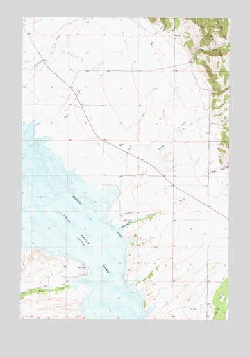
Canyon Ferry SE, MT USGS Topographic Map
Click on map above to begin viewing in our Map Viewer.

This topographic map contains these locations and features:
Feature Name Type Latitude Longitude GNIS ID View Map
09N01E22DB__01 WellWellN46.5213°W111.5855°816636View Map
09N01E22DB__02 WellWellN46.5213°W111.5855°816637View Map
09N01E22DC__01 WellWellN46.5177°W111.5855°816619View Map
09N01E25DA__01 WellWellN46.5069°W111.5389°816571View Map
09N01E26DC__01 WellWellN46.5033°W111.5647°816554View Map
09N01E26DC__03 WellWellN46.5033°W111.5647°816555View Map
09N01E27AA__01 WellWellN46.5141°W111.5805°816602View Map
09N01E27AA__02 WellWellN46.5141°W111.5805°816603View Map
09N01E28AAA_01 WellWellN46.5144°W111.6005°816604View Map
09N02E06DD__01 WellWellN46.5594°W111.5161°816819View Map
09N02E19DA__01 WellWellN46.5194°W111.5161°816625View Map
09N02E19DA__02 WellWellN46.5194°W111.5161°816626View Map
09N02E20DB__01 WellWellN46.5194°W111.5002°816624View Map
09N02E29CB__01 WellWellN46.5049°W111.5108°816565View Map
10N01E22CBD_01 WellWellN46.6077°W111.5950°817089View Map
10N01E28AD__01 WellWellN46.5980°W111.6008°817032View Map
10N01E28ADCB01 WellWellN46.5974°W111.6019°817031View Map
10N01E28CABB01 WellWellN46.5958°W111.6122°817017View Map
Beaver CreekStreamN46.5163°W111.5855°779607View Map
Beaver Creek Cemetery (historical)CemeteryN46.5152°W111.5953°1762267View Map
Beaver Creek School (historical)SchoolN46.5163°W111.5680°798953View Map
Bilk GulchValleyN46.5733°W111.6136°779905View Map
Canyon Ferry LakeReservoirN46.5469°W111.6050°800551View Map
Goose BayBayN46.5391°W111.5622°784105View Map
Goose Bay Marina CampgroundLocaleN46.5416°W111.5619°1762257View Map
Grubb GulchValleyN46.5419°W111.5536°784397View Map
Number Sixteen GulchValleyN46.6144°W111.5030°788337View Map
Spring CreekStreamN46.5549°W111.5661°791250View Map
White CreekStreamN46.5535°W111.5689°793192View Map
White Earth CampgroundLocaleN46.5219°W111.5855°793195View Map
White Earth Recreation AreaParkN46.5219°W111.5855°1762259View Map
White GulchValleyN46.6063°W111.5230°793196View Map

Note: Coordinates in the location and feature list above are referenced to NAD83 datum.


Copyright (C) 2008-2025 Ryan Niemi / Sunset Dynamics ... All Rights Reserved