TopoQuest Logo
Do you find TopoQuest useful?
Help keep TopoQuest running and adding new maps/features by donating!
Bitcoin:  19c7KJd3qBynnjoSw5npx9KScwjBe4ifkT
Litecoin:  LXs6TkuXGGXo1vDsWCkWVdjQX94eUKd6ui
Home View Maps Find Maps Find Places Resources & Links


Savannah, Missouri Topographic Map

USGS Map Title: Savannah, MO
USGS Map MRC: 39094H7
DRG (GeoTIFF) Download: o39094h7.tif


Neighboring USGS Topographic Map Quads:


  Fillmore, MO  
40094A8
 

  Bolckow, MO  
40094A7
 

  Whitesville, MO  
40094A6
 

  Amazonia, MO  
39094H8
 

  Savannah, MO  
39094H7
 

  Helena, MO  
39094H6
 

  Wathena, KS  
39094G8
 

  Saint Joseph North, MO  
39094G7
 

  Cosby, MO  
39094G6


Map MRC Location:

N40°
W95°
N40°
W94°
H8 H7 H6 H5 H4 H3 H2 H1
G8 G7 G6 G5 G4 G3 G2 G1
F8 F7 F6 F5 F4 F3 F2 F1
E8 E7 E6 E5 E4 E3 E2 E1
D8 D7 D6 D5 D4 D3 D2 D1
C8 C7 C6 C5 C4 C3 C2 C1
B8 B7 B6 B5 B4 B3 B2 B1
A8 A7 A6 A5 A4 A3 A2 A1
N39°
W95°
N39°
W94°

Savannah, MO USGS 1:24K Topographic Map Preview:
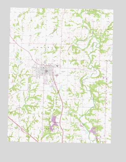
Savannah, MO USGS Topographic Map
Click on map above to begin viewing in our Map Viewer.

This topographic map contains these locations and features:
Feature Name Type Latitude Longitude GNIS ID View Map
Andrew CountyCivilN39.9835°W94.8020°758456View Map
Andrew County LakeReservoirN39.9260°W94.8123°760321View Map
Andrew County Lake DamDamN39.9250°W94.8136°760320View Map
Andrew County Sheriff's OfficeBuildingN39.9411°W94.8195°2752468View Map
Barr SchoolSchoolN39.9008°W94.8327°746477View Map
Bedford Chapel (historical)ChurchN39.9961°W94.7644°746480View Map
City of SavannahCivilN39.9391°W94.8279°2396545View Map
City ReservoirReservoirN39.9505°W94.8631°758264View Map
Coffman CemeteryCemeteryN39.9961°W94.8102°716073View Map
Coffman SchoolSchoolN39.9994°W94.8089°746479View Map
County FarmLocaleN39.9350°W94.7569°746483View Map
Cumberland Ridge ChurchChurchN39.8936°W94.8127°716590View Map
Dakin School (historical)SchoolN39.9153°W94.7947°746485View Map
Dewitt School (historical)SchoolN39.9450°W94.7941°746482View Map
Earls CemeteryCemeteryN39.9375°W94.8030°717241View Map
Ford LakeReservoirN39.9408°W94.8644°761101View Map
Ford Lake DamDamN39.9400°W94.8652°761100View Map
Greenwick CemeteryCemeteryN39.8867°W94.8655°718833View Map
Howard SchoolSchoolN39.9525°W94.8505°746476View Map
Kelley LakeReservoirN39.9644°W94.7523°760979View Map
Kelley Lake DamDamN39.9650°W94.7536°760978View Map
Kellogg CemeteryCemeteryN39.9961°W94.8497°720508View Map
KodiakPopulated PlaceN39.9519°W94.7572°740996View Map
Minnie Cline Elementary SchoolSchoolN39.9387°W94.8348°2545120View Map
Mount Pleasant School (historical)SchoolN39.9778°W94.8083°746481View Map
Mount Pleasant School (historical)SchoolN39.9742°W94.8422°747059View Map
Republican School (historical)SchoolN39.9950°W94.7658°747060View Map
Salem School (historical)SchoolN39.9225°W94.7597°746484View Map
SavannahPopulated PlaceN39.9417°W94.8302°726070View Map
Savannah CemeteryCemeteryN39.9361°W94.8292°2681281View Map
Savannah City Reservoir DamDamN39.9483°W94.8636°760252View Map
Savannah Fire DepartmentBuildingN39.9406°W94.8205°2620354View Map
Savannah High SchoolSchoolN39.9458°W94.8170°2545419View Map
Savannah Middle SchoolSchoolN39.9443°W94.8332°2545317View Map
Savannah Post OfficePost OfficeN39.9418°W94.8307°2782564View Map
Savannah Rural Fire DistrictBuildingN39.9406°W94.8206°2621475View Map
Schuster (historical)LocaleN39.9989°W94.8158°740222View Map
Township of NodawayCivilN39.9595°W94.8273°766227View Map
Washington SchoolSchoolN39.9011°W94.8616°746478View Map
Woodlawn SchoolSchoolN39.8967°W94.7580°746486View Map
Worth AirportAirportN39.9809°W94.8748°758933View Map

Note: Coordinates in the location and feature list above are referenced to NAD83 datum.


Copyright (C) 2008-2025 Ryan Niemi / Sunset Dynamics ... All Rights Reserved