TopoQuest Logo
Do you find TopoQuest useful?
Help keep TopoQuest running and adding new maps/features by donating!
Bitcoin:  19c7KJd3qBynnjoSw5npx9KScwjBe4ifkT
Litecoin:  LXs6TkuXGGXo1vDsWCkWVdjQX94eUKd6ui
Home View Maps Find Maps Find Places Resources & Links


Woodville, Mississippi Topographic Map

USGS Map Title: Woodville, MS
USGS Map MRC: 31091A3
DRG (GeoTIFF) Download: o31091a3.tif


Neighboring USGS Topographic Map Quads:


  Lessley, MS  
31091B4
 

  Laneheart, MS  
31091B3
 

  Wilkinson, MS  
31091B2
 

  Pinckneyville, MS  
31091A4
 

  Woodville, MS  
31091A3
 

  Newtonia, MS  
31091A2
 

  Weyanoke, LA  
30091H4
 

  Laurel Hill, LA  
30091H3
 

  Rogillioville, LA  
30091H2


Map MRC Location:

N32°
W92°
N32°
W91°
H8 H7 H6 H5 H4 H3 H2 H1
G8 G7 G6 G5 G4 G3 G2 G1
F8 F7 F6 F5 F4 F3 F2 F1
E8 E7 E6 E5 E4 E3 E2 E1
D8 D7 D6 D5 D4 D3 D2 D1
C8 C7 C6 C5 C4 C3 C2 C1
B8 B7 B6 B5 B4 B3 B2 B1
A8 A7 A6 A5 A4 A3 A2 A1
N31°
W92°
N31°
W91°

Woodville, MS USGS 1:24K Topographic Map Preview:
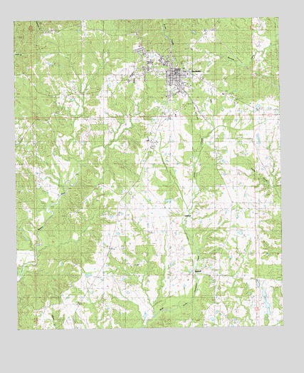
Woodville, MS USGS Topographic Map
Click on map above to begin viewing in our Map Viewer.

This topographic map contains these locations and features:
Feature Name Type Latitude Longitude GNIS ID View Map
Angola SchoolSchoolN31.1227°W91.3473°666271View Map
AshwoodPopulated PlaceN31.0449°W91.2971°691674View Map
Ashwood ChurchChurchN31.0516°W91.2921°666402View Map
Bay Ridge SchoolSchoolN31.0513°W91.2734°666587View Map
Beach Grove ChurchChurchN31.0888°W91.2523°666622View Map
Bowling Green CemeteryCemeteryN31.0779°W91.2679°667479View Map
Currier CemeteryCemeteryN31.1041°W91.2848°669025View Map
Dawson CemeteryCemeteryN31.0460°W91.3523°669150View Map
Deer Park SchoolSchoolN31.0774°W91.3740°669205View Map
James A Ventress Lake DamDamN31.0918°W91.3601°680570View Map
John C Hughes Lake DamDamN31.0918°W91.2668°680569View Map
Jones CreekStreamN31.0474°W91.2940°671988View Map
Liddell CemeteryCemeteryN31.0752°W91.3104°672488View Map
Magnolia SchoolSchoolN31.0093°W91.2809°673083View Map
Powell CemeteryCemeteryN31.0454°W91.2607°676286View Map
Saint John ChurchChurchN31.0168°W91.3501°677049View Map
Saint Luke School Number 2SchoolN31.0588°W91.3362°677114View Map
Saint Peters ChurchChurchN31.1210°W91.2801°677238View Map
Sweeney CemeteryCemeteryN31.1088°W91.2887°678461View Map
Town of WoodvilleCivilN31.1029°W91.2993°2406915View Map
TurnbullPopulated PlaceN31.0224°W91.2921°692280View Map
Wilkinson CemeteryCemeteryN31.1071°W91.2601°679696View Map
Wilkinson County Elementary SchoolSchoolN31.1010°W91.3023°707619View Map
Wilkinson County High SchoolSchoolN31.0991°W91.2962°707620View Map
Wilkinson County Sheriff's OfficeBuildingN31.1037°W91.2984°2754083View Map
WoodvillePopulated PlaceN31.1046°W91.2996°679870View Map
Woodville Attendance CenterSchoolN31.0946°W91.2982°707621View Map
Woodville Fire DepartmentBuildingN31.1043°W91.3009°2667839View Map
Woodville Police DepartmentBuildingN31.1028°W91.2993°2754232View Map
Woodville Post OfficePost OfficeN31.1047°W91.2962°2768603View Map

Note: Coordinates in the location and feature list above are referenced to NAD83 datum.


Copyright (C) 2008-2025 Ryan Niemi / Sunset Dynamics ... All Rights Reserved