TopoQuest Logo
Do you find TopoQuest useful?
Help keep TopoQuest running and adding new maps/features by donating!
Bitcoin:  19c7KJd3qBynnjoSw5npx9KScwjBe4ifkT
Litecoin:  LXs6TkuXGGXo1vDsWCkWVdjQX94eUKd6ui
Home View Maps Find Maps Find Places Resources & Links


Cedarton, Louisiana Topographic Map

USGS Map Title: Cedarton, LA
USGS Map MRC: 32092F5
DRG (GeoTIFF) Download: o32092f5.tif


Neighboring USGS Topographic Map Quads:


  Bernice, LA  
32092G6
 

  Shiloh, LA  
32092G5
 

  Farmerville, LA  
32092G4
 

  Dubach, LA  
32092F6
 

  Cedarton, LA  
32092F5
 

  Downsville North, LA  
32092F4
 

  Ruston West, LA  
32092E6
 

  Ruston East, LA  
32092E5
 

  Downsville South, LA  
32092E4


Map MRC Location:

N33°
W93°
N33°
W92°
H8 H7 H6 H5 H4 H3 H2 H1
G8 G7 G6 G5 G4 G3 G2 G1
F8 F7 F6 F5 F4 F3 F2 F1
E8 E7 E6 E5 E4 E3 E2 E1
D8 D7 D6 D5 D4 D3 D2 D1
C8 C7 C6 C5 C4 C3 C2 C1
B8 B7 B6 B5 B4 B3 B2 B1
A8 A7 A6 A5 A4 A3 A2 A1
N32°
W93°
N32°
W92°

Cedarton, LA USGS 1:24K Topographic Map Preview:
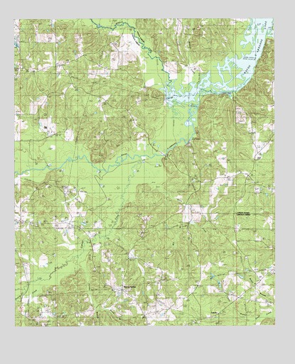
Cedarton, LA USGS Topographic Map
Click on map above to begin viewing in our Map Viewer.

This topographic map contains these locations and features:
Feature Name Type Latitude Longitude GNIS ID View Map
Andy BranchStreamN32.6871°W92.6232°546538View Map
Basin BranchStreamN32.7015°W92.5404°546544View Map
Beach BranchStreamN32.6329°W92.5857°532816View Map
Bryant CemeteryCemeteryN32.6532°W92.5415°533488View Map
Caney BranchStreamN32.6296°W92.5024°533735View Map
CedartonPopulated PlaceN32.6301°W92.5276°543068View Map
Colvin Barmore CemeteryCemeteryN32.6507°W92.6213°534060View Map
Colvin CreekStreamN32.6404°W92.6213°554057View Map
Colvin T R CemeteryCemeteryN32.6263°W92.6188°534059View Map
CulbertsonPopulated PlaceN32.6863°W92.5129°548705View Map
Culbertson CemeteryCemeteryN32.6874°W92.5171°544053View Map
Culbertson ChurchChurchN32.6874°W92.5165°548706View Map
Culbertson SchoolSchoolN32.6876°W92.5171°534303View Map
Cypress CreekStreamN32.6943°W92.5654°534363View Map
Evergreen ChurchChurchN32.7499°W92.5465°534868View Map
Fellowship Baptist ChurchChurchN32.7299°W92.6235°546572View Map
Fellowship CemeteryCemeteryN32.7293°W92.6226°546573View Map
Fellowship SchoolSchoolN32.7299°W92.6240°534928View Map
Gills FerryPopulated PlaceN32.7182°W92.5224°546579View Map
Greenville SchoolSchoolN32.6438°W92.5079°535405View Map
Little Colvin CreekStreamN32.6435°W92.6104°536519View Map
Middle Fork Bayou D'ArbonneStreamN32.7188°W92.5476°547690View Map
Mill BranchStreamN32.6710°W92.5424°537095View Map
Mineral SpringsPopulated PlaceN32.6399°W92.5738°540801View Map
Mineral Springs Baptist ChurchChurchN32.6399°W92.5765°555331View Map
Pleasant Grove ChurchChurchN32.6704°W92.6226°546620View Map
Pleasant Grove SchoolSchoolN32.6704°W92.6229°538251View Map
Redden CreekStreamN32.7218°W92.5349°538534View Map
Rock CornerPopulated PlaceN32.6418°W92.5376°546626View Map
Rock Corner Baptist ChurchChurchN32.6410°W92.5371°555817View Map
Rock Corner School (historical)SchoolN32.6415°W92.5374°546627View Map
Sixteen BranchStreamN32.6557°W92.5921°539406View Map
Smith CreekStreamN32.6949°W92.5540°539442View Map
Unionville Gas FieldOilfieldN32.6560°W92.5738°540114View Map

Note: Coordinates in the location and feature list above are referenced to NAD83 datum.


Copyright (C) 2008-2025 Ryan Niemi / Sunset Dynamics ... All Rights Reserved