TopoQuest Logo
Do you find TopoQuest useful?
Help keep TopoQuest running and adding new maps/features by donating!
Bitcoin:  19c7KJd3qBynnjoSw5npx9KScwjBe4ifkT
Litecoin:  LXs6TkuXGGXo1vDsWCkWVdjQX94eUKd6ui
Home View Maps Find Maps Find Places Resources & Links


Downsville North, Louisiana Topographic Map

USGS Map Title: Downsville North, LA
USGS Map MRC: 32092F4
DRG (GeoTIFF) Download: o32092f4.tif


Neighboring USGS Topographic Map Quads:


  Shiloh, LA  
32092G5
 

  Farmerville, LA  
32092G4
 

  De Loutre, LA  
32092G3
 

  Cedarton, LA  
32092F5
 

  Downsville North, LA  
32092F4
 

  Point, LA  
32092F3
 

  Ruston East, LA  
32092E5
 

  Downsville South, LA  
32092E4
 

  Calhoun, LA  
32092E3


Map MRC Location:

N33°
W93°
N33°
W92°
H8 H7 H6 H5 H4 H3 H2 H1
G8 G7 G6 G5 G4 G3 G2 G1
F8 F7 F6 F5 F4 F3 F2 F1
E8 E7 E6 E5 E4 E3 E2 E1
D8 D7 D6 D5 D4 D3 D2 D1
C8 C7 C6 C5 C4 C3 C2 C1
B8 B7 B6 B5 B4 B3 B2 B1
A8 A7 A6 A5 A4 A3 A2 A1
N32°
W93°
N32°
W92°

Downsville North, LA USGS 1:24K Topographic Map Preview:
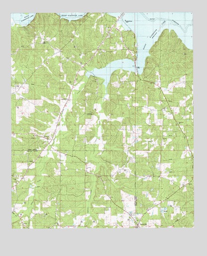
Downsville North, LA USGS Topographic Map
Click on map above to begin viewing in our Map Viewer.

This topographic map contains these locations and features:
Feature Name Type Latitude Longitude GNIS ID View Map
Bayou D'Arbonne Gas FieldOilfieldN32.7399°W92.4665°548695View Map
Bethel ChurchChurchN32.6590°W92.4235°532980View Map
Boggy BranchStreamN32.6346°W92.4954°533298View Map
Cane CreekStreamN32.7429°W92.3771°533712View Map
Cedar Grove CemeteryCemeteryN32.6857°W92.3865°533837View Map
Cox FerryPopulated PlaceN32.7349°W92.3988°548704View Map
Cypress CreekStreamN32.7168°W92.4357°554169View Map
D'ArbonnePopulated PlaceN32.6749°W92.4743°541082View Map
D'Arbonne Gas FieldOilfieldN32.7043°W92.4974°548707View Map
D'Arbonne Lookout TowerTowerN32.6926°W92.4463°558758View Map
DownsvillePopulated PlaceN32.6268°W92.4143°534579View Map
Downsville CemeteryCemeteryN32.6299°W92.4151°544055View Map
Feazel CemeteryCemeteryN32.6987°W92.4624°554385View Map
HolmesvillePopulated PlaceN32.6932°W92.3965°1630764View Map
Holmesville CemeteryCemeteryN32.6768°W92.3957°544059View Map
Holmesville ChurchChurchN32.6943°W92.3968°535745View Map
Hopewell School (historical)SchoolN32.6338°W92.4696°546592View Map
Millard Hill ChurchChurchN32.7107°W92.4413°540802View Map
Millard Hill SchoolSchoolN32.7104°W92.4418°537121View Map
Mount Nebo ChurchChurchN32.6765°W92.3968°537345View Map
Mount Zion ChurchChurchN32.6540°W92.4976°537452View Map
Saint Pauls ChurchChurchN32.6507°W92.3788°540803View Map
Sardis CemeteryCemeteryN32.7224°W92.4612°544064View Map
Sardis ChurchChurchN32.7229°W92.4618°539182View Map
Stowe CreekStreamN32.7449°W92.3943°556150View Map
Stowe Creek Gas FieldOilfieldN32.6924°W92.4557°548731View Map
Terral CemeteryCemeteryN32.6937°W92.3954°544066View Map
Village of DownsvilleCivilN32.6264°W92.4129°2407442View Map
Ward 5 Volunteer Fire DepartmentBuildingN32.6855°W92.3863°2672805View Map
Woodlawn ChurchChurchN32.7004°W92.4915°540525View Map

Note: Coordinates in the location and feature list above are referenced to NAD83 datum.


Copyright (C) 2008-2025 Ryan Niemi / Sunset Dynamics ... All Rights Reserved