TopoQuest Logo
Do you find TopoQuest useful?
Help keep TopoQuest running and adding new maps/features by donating!
Bitcoin:  19c7KJd3qBynnjoSw5npx9KScwjBe4ifkT
Litecoin:  LXs6TkuXGGXo1vDsWCkWVdjQX94eUKd6ui
Home View Maps Find Maps Find Places Resources & Links


Downsville South, Louisiana Topographic Map

USGS Map Title: Downsville South, LA
USGS Map MRC: 32092E4
DRG (GeoTIFF) Download: o32092e4.tif


Neighboring USGS Topographic Map Quads:


  Cedarton, LA  
32092F5
 

  Downsville North, LA  
32092F4
 

  Point, LA  
32092F3
 

  Ruston East, LA  
32092E5
 

  Downsville South, LA  
32092E4
 

  Calhoun, LA  
32092E3
 

  Vernon, LA  
32092D5
 

  Eros, LA  
32092D4
 

  Cadeville, LA  
32092D3


Map MRC Location:

N33°
W93°
N33°
W92°
H8 H7 H6 H5 H4 H3 H2 H1
G8 G7 G6 G5 G4 G3 G2 G1
F8 F7 F6 F5 F4 F3 F2 F1
E8 E7 E6 E5 E4 E3 E2 E1
D8 D7 D6 D5 D4 D3 D2 D1
C8 C7 C6 C5 C4 C3 C2 C1
B8 B7 B6 B5 B4 B3 B2 B1
A8 A7 A6 A5 A4 A3 A2 A1
N32°
W93°
N32°
W92°

Downsville South, LA USGS 1:24K Topographic Map Preview:
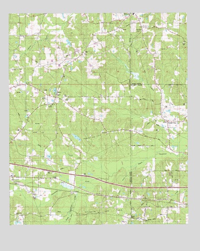
Downsville South, LA USGS Topographic Map
Click on map above to begin viewing in our Map Viewer.

This topographic map contains these locations and features:
Feature Name Type Latitude Longitude GNIS ID View Map
Atley Donaldson Pond DamDamN32.6051°W92.4585°556957View Map
Averit (historical)Populated PlaceN32.5168°W92.4335°546542View Map
Beulah ChurchChurchN32.5035°W92.4051°533003View Map
Calhoun ChurchChurchN32.5151°W92.3940°540905View Map
Choudrant CreekStreamN32.5196°W92.4524°553985View Map
CHOUDRANT ELEMENTARY SCHOOLSchoolN32.5270°W92.4985°1629819View Map
Clear CreekStreamN32.5343°W92.4154°533986View Map
Downsville High SchoolSchoolN32.6243°W92.4127°548709View Map
Frost TownPopulated PlaceN32.5571°W92.3890°548367View Map
Lane SchoolSchoolN32.6135°W92.4079°536327View Map
Lanes ChapelChurchN32.6151°W92.4071°540907View Map
Macedonia ChurchChurchN32.5538°W92.4318°536798View Map
Macedonia School (historical)SchoolN32.5543°W92.4318°546605View Map
Mount Sinai ChurchChurchN32.5713°W92.4704°540904View Map
New Hope Baptist ChurchChurchN32.6107°W92.4890°555476View Map
North Carlton Gas FieldOilfieldN32.5765°W92.3982°548495View Map
Parish Governing Authority District 5CivilN32.5784°W92.4861°1930085View Map
Pleasant Grove Baptist ChurchChurchN32.5065°W92.4949°555678View Map
Pleasant Grove CemeteryCemeteryN32.5057°W92.4963°546619View Map
Pleasant Grove School (historical)SchoolN32.5065°W92.4957°546621View Map
Pleasant ValleyPopulated PlaceN32.5610°W92.3896°540906View Map
Pleasant Valley Assembly of God ChurchChurchN32.5607°W92.3896°555686View Map
Saints Rest ChurchChurchN32.5254°W92.4963°539088View Map
SibleyPopulated PlaceN32.5757°W92.4674°539363View Map
SmurneyPopulated PlaceN32.6068°W92.3754°541192View Map
Smyrna CemeteryCemeteryN32.6074°W92.3774°540908View Map
South Choudrant CreekStreamN32.5304°W92.4263°556086View Map
South Downsville Gas FieldOilfieldN32.6043°W92.4154°557083View Map
Squire CreekStreamN32.5307°W92.4268°556129View Map
TremontPopulated PlaceN32.5193°W92.4549°539981View Map
Tremont Gas FieldOilfieldN32.5465°W92.4432°539982View Map
Zion Traveler Baptist ChurchChurchN32.5757°W92.4199°556501View Map

Note: Coordinates in the location and feature list above are referenced to NAD83 datum.


Copyright (C) 2008-2025 Ryan Niemi / Sunset Dynamics ... All Rights Reserved