TopoQuest Logo
Do you find TopoQuest useful?
Help keep TopoQuest running and adding new maps/features by donating!
Bitcoin:  19c7KJd3qBynnjoSw5npx9KScwjBe4ifkT
Litecoin:  LXs6TkuXGGXo1vDsWCkWVdjQX94eUKd6ui
Home View Maps Find Maps Find Places Resources & Links


Buffalo Mills, Pennsylvania Topographic Map

USGS Map Title: Buffalo Mills, PA
USGS Map MRC: 39078H6
DRG (GeoTIFF) Download: o39078h6.tif


Neighboring USGS Topographic Map Quads:


  Central City, PA  
40078A7
 

  Schellsburg, PA  
40078A6
 

  Bedford, PA  
40078A5
 

  New Baltimore, PA  
39078H7
 

  Buffalo Mills, PA  
39078H6
 

  Rainsburg, PA  
39078H5
 

  Fairhope, PA  
39078G7
 

  Hyndman, PA  
39078G6
 

  Beans Cove, PA  
39078G5


Map MRC Location:

N40°
W79°
N40°
W78°
H8 H7 H6 H5 H4 H3 H2 H1
G8 G7 G6 G5 G4 G3 G2 G1
F8 F7 F6 F5 F4 F3 F2 F1
E8 E7 E6 E5 E4 E3 E2 E1
D8 D7 D6 D5 D4 D3 D2 D1
C8 C7 C6 C5 C4 C3 C2 C1
B8 B7 B6 B5 B4 B3 B2 B1
A8 A7 A6 A5 A4 A3 A2 A1
N39°
W79°
N39°
W78°

Buffalo Mills, PA USGS 1:24K Topographic Map Preview:
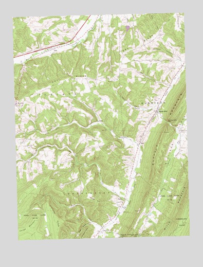
Buffalo Mills, PA USGS Topographic Map
Click on map above to begin viewing in our Map Viewer.

This topographic map contains these locations and features:
Feature Name Type Latitude Longitude GNIS ID View Map
BardPopulated PlaceN39.9279°W78.6592°1988989View Map
Buffalo MillsPopulated PlaceN39.9334°W78.6459°1170607View Map
Buffalo Mills GapGapN39.9384°W78.6367°1170608View Map
Buffalo Mills Post OfficePost OfficeN39.9462°W78.6459°2777463View Map
Buffalo MountainSummitN39.9237°W78.6470°1170611View Map
Buffalo Run School (historical)SchoolN39.9592°W78.6372°1200808View Map
Camp Run CemeteryCemeteryN39.9229°W78.7361°1171083View Map
Camp Run Church (historical)ChurchN39.9226°W78.7364°1200944View Map
Coughenour SchoolSchoolN39.8809°W78.6881°1201084View Map
Curley School (historical)SchoolN39.9845°W78.7056°1200961View Map
Diehl SchoolSchoolN39.9867°W78.6895°1200960View Map
Dry RidgeRidgeN39.9809°W78.6581°1173521View Map
Dry Ridge Lutheran CemeteryCemeteryN39.9874°W78.6435°2776073View Map
Ealy SchoolSchoolN39.9042°W78.7122°1200942View Map
Evitts MountainRidgeN39.9251°W78.7250°1192439View Map
Glade Pike VistaSummitN39.9979°W78.6431°1201872View Map
Gravel PitPopulated PlaceN39.8787°W78.6889°1176007View Map
Gravel Pit StationLocaleN39.8784°W78.6978°1200941View Map
Huffman School (historical)SchoolN39.9020°W78.6431°1200940View Map
Johnston RidgeRidgeN39.8837°W78.7189°1178128View Map
Joseph Smyth DamDamN39.9933°W78.6651°1194467View Map
KeggPopulated PlaceN39.9820°W78.7203°1203920View Map
Lake FrancisReservoirN39.9923°W78.6662°1194466View Map
Leap Airport (historical)AirportN39.8904°W78.6734°1193764View Map
Lybarger CemeteryCemeteryN39.8952°W78.6730°2776104View Map
Lybarger ChurchChurchN39.8948°W78.6736°1180095View Map
Lybarger HillSummitN39.8970°W78.6945°1180096View Map
MadleyPopulated PlaceN39.8981°W78.6731°1180188View Map
Madley CemeteryCemeteryN39.8956°W78.6741°2776105View Map
Milligan Cove ChurchChurchN39.9348°W78.6289°1181266View Map
Milligan RunStreamN39.9356°W78.6325°1181268View Map
Milligans Cove Christian Church CemeteryCemeteryN39.9347°W78.6291°2776112View Map
Mount Nebo School (historical)SchoolN39.8845°W78.7259°1200943View Map
Mowry SchoolSchoolN39.9406°W78.6895°1200946View Map
Old Philson SchoolSchoolN39.9731°W78.7420°1200962View Map
Old Union CemeteryCemeteryN39.9737°W78.7417°1182947View Map
Orchard HollowValleyN39.9727°W78.6257°1183023View Map
Pleasant Ridge ChurchChurchN39.9281°W78.7425°1200111View Map
Pleasant Ridge Church CemeteryCemeteryN39.9274°W78.7427°2776140View Map
Pleasant Ridge SchoolSchoolN39.9281°W78.7425°1209042View Map
Powell School (historical)SchoolN39.9931°W78.6639°1200958View Map
Ridge School (historical)SchoolN39.9642°W78.6859°1200959View Map
RockvillePopulated PlaceN39.9309°W78.6711°1185326View Map
Saint James Church (historical)ChurchN39.9876°W78.6439°1200957View Map
Savage MountainSummitN39.8865°W78.7361°1193292View Map
Shroyer Farm CemeteryCemeteryN39.9197°W78.7274°2776161View Map
Smally Spring BranchStreamN39.9492°W78.6436°1187841View Map
State Game Lands Number 48ParkN39.8756°W78.6661°1193455View Map
Sugar HollowValleyN39.8836°W78.6973°1188949View Map
Tar Water CreekStreamN39.8815°W78.6878°1189274View Map
Township of HarrisonCivilN39.9619°W78.6254°1215894View Map
Township of JuniataCivilN39.9873°W78.7201°1215896View Map
Trinity United Church of Christ CemeteryCemeteryN39.9632°W78.6789°2776172View Map
Wagerman Family CemeteryCemeteryN39.9230°W78.7258°2776176View Map
West EndPopulated PlaceN39.9520°W78.7486°1191009View Map
West End Post Office (historical)Post OfficeN39.9520°W78.7486°1214504View Map
West End School (historical)SchoolN39.9412°W78.7350°1200945View Map
Wolf Camp RunStreamN39.8948°W78.6684°1193680View Map

Note: Coordinates in the location and feature list above are referenced to NAD83 datum.


Copyright (C) 2008-2025 Ryan Niemi / Sunset Dynamics ... All Rights Reserved