TopoQuest Logo
Do you find TopoQuest useful?
Help keep TopoQuest running and adding new maps/features by donating!
Bitcoin:  19c7KJd3qBynnjoSw5npx9KScwjBe4ifkT
Litecoin:  LXs6TkuXGGXo1vDsWCkWVdjQX94eUKd6ui
Home View Maps Find Maps Find Places Resources & Links


Cerro Del Oro, New Mexico Topographic Map

USGS Map Title: Cerro Del Oro, NM
USGS Map MRC: 34107F4
DRG (GeoTIFF) Download: o34107f4.tif


Neighboring USGS Topographic Map Quads:


  East Mesa, NM  
34107G5
 

  Marmon Ranch, NM  
34107G4
 

  Cerro Verde, NM  
34107G3
 

  Broom Mountain, NM  
34107F5
 

  Cerro Del Oro, NM  
34107F4
 

  Chicken Mountain, NM  
34107F3
 

  Pueblo Viejo Mesa, NM  
34107E5
 

  Field Ranch, NM  
34107E4
 

  Puerto De Los Cavadores, NM  
34107E3


Map MRC Location:

N35°
W108°
N35°
W107°
H8 H7 H6 H5 H4 H3 H2 H1
G8 G7 G6 G5 G4 G3 G2 G1
F8 F7 F6 F5 F4 F3 F2 F1
E8 E7 E6 E5 E4 E3 E2 E1
D8 D7 D6 D5 D4 D3 D2 D1
C8 C7 C6 C5 C4 C3 C2 C1
B8 B7 B6 B5 B4 B3 B2 B1
A8 A7 A6 A5 A4 A3 A2 A1
N34°
W108°
N34°
W107°

Cerro Del Oro, NM USGS 1:24K Topographic Map Preview:
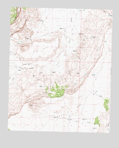
Cerro Del Oro, NM USGS Topographic Map
Click on map above to begin viewing in our Map Viewer.

This topographic map contains these locations and features:
Feature Name Type Latitude Longitude GNIS ID View Map
Abran SpringSpringN34.6704°W107.4598°885540View Map
Axtell Water WellWellN34.6376°W107.4242°918574View Map
Axtell WindmillLocaleN34.6378°W107.4245°885959View Map
Big Pasture TankReservoirN34.7245°W107.4155°886317View Map
Bill Aseyna TankReservoirN34.6295°W107.3954°886379View Map
Blue Water CreekStreamN34.6920°W107.4684°903955View Map
Caņon Palo BlancoValleyN34.7342°W107.4223°897836View Map
Caņon Villa de AseynaValleyN34.6345°W107.3953°897853View Map
Cerro del OroSummitN34.6512°W107.4734°897875View Map
Double TankReservoirN34.6627°W107.3882°888480View Map
Gunn MesaSummitN34.7073°W107.4828°889659View Map
Hillside TankReservoirN34.7217°W107.3986°890019View Map
Holding Pasture TankReservoirN34.7294°W107.4393°890066View Map
Horse Pasture TankReservoirN34.7364°W107.4599°890166View Map
Jonah TankReservoirN34.6395°W107.4405°890533View Map
Lake ErieLakeN34.7436°W107.3756°888897View Map
Lonely WindmillLocaleN34.6848°W107.4592°891282View Map
Lower Axtell TankReservoirN34.6387°W107.4086°891417View Map
Mesa del OroSummitN34.6389°W107.4839°899778View Map
Ojo GrandeSpringN34.6636°W107.4518°898095View Map
Orchard PlaceLocaleN34.6928°W107.4770°898685View Map
Palo Blanco SpringSpringN34.7070°W107.4221°893046View Map
Petaca PintaRidgeN34.7403°W107.4914°893205View Map
Petaca Plata Wilderness Study AreaParkN34.7403°W107.4914°935848View Map
Point Trail SpringSpringN34.6851°W107.4473°893377View Map
Rim TankReservoirN34.6836°W107.3952°893909View Map
Salado SpringSpringN34.6864°W107.4886°894312View Map
Seis-Wilson Detention Dam Number 1DamN34.7301°W107.4606°923843View Map
Seis-Wilson RanchLocaleN34.7184°W107.4773°894708View Map
Theodocio SpringSpringN34.6848°W107.4170°895616View Map
Twin TankReservoirN34.6812°W107.4684°895955View Map

Note: Coordinates in the location and feature list above are referenced to NAD83 datum.


Copyright (C) 2008-2024 Ryan Niemi / Sunset Dynamics ... All Rights Reserved