TopoQuest Logo
Do you find TopoQuest useful?
Help keep TopoQuest running and adding new maps/features by donating!
Bitcoin:  19c7KJd3qBynnjoSw5npx9KScwjBe4ifkT
Litecoin:  LXs6TkuXGGXo1vDsWCkWVdjQX94eUKd6ui
Home View Maps Find Maps Find Places Resources & Links


Chatfield, Ohio Topographic Map

USGS Map Title: Chatfield, OH
USGS Map MRC: 40082H8
DRG (GeoTIFF) Download: o40082h8.tif


Neighboring USGS Topographic Map Quads:


  Bloomville, OH  
41083A1
 

  Attica, OH  
41082A8
 

  Centerton, OH  
41082A7
 

  Lykens, OH  
40083H1
 

  Chatfield, OH  
40082H8
 

  New Washington, OH  
40082H7
 

  Oceola, OH  
40083G1
 

  Bucyrus, OH  
40082G8
 

  North Robinson, OH  
40082G7


Map MRC Location:

N41°
W83°
N41°
W82°
H8 H7 H6 H5 H4 H3 H2 H1
G8 G7 G6 G5 G4 G3 G2 G1
F8 F7 F6 F5 F4 F3 F2 F1
E8 E7 E6 E5 E4 E3 E2 E1
D8 D7 D6 D5 D4 D3 D2 D1
C8 C7 C6 C5 C4 C3 C2 C1
B8 B7 B6 B5 B4 B3 B2 B1
A8 A7 A6 A5 A4 A3 A2 A1
N40°
W83°
N40°
W82°

Chatfield, OH USGS 1:24K Topographic Map Preview:
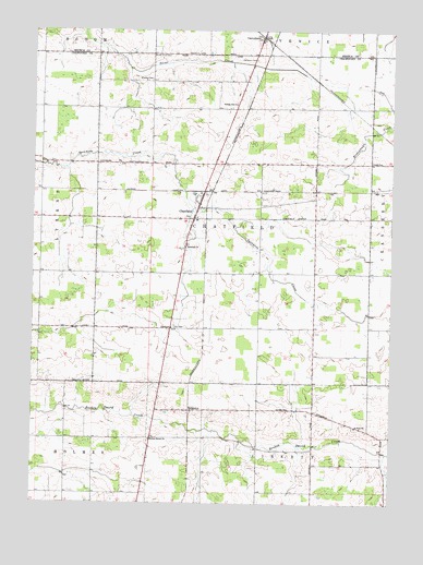
Chatfield, OH USGS Topographic Map
Click on map above to begin viewing in our Map Viewer.

This topographic map contains these locations and features:
Feature Name Type Latitude Longitude GNIS ID View Map
Brenner CemeteryCemeteryN40.9203°W82.9016°1963170View Map
Broken Sword ChurchChurchN40.8917°W82.9585°1038340View Map
Buchman CemeteryCemeteryN40.9923°W82.9232°1038444View Map
Buckeye West Elementary SchoolSchoolN40.9501°W82.9430°1055725View Map
CarrothersPopulated PlaceN40.9981°W82.9221°1048584View Map
Carrothers Post OfficePost OfficeN40.9987°W82.9227°2045556View Map
ChatfieldPopulated PlaceN40.9503°W82.9449°1056792View Map
Chatfield Fire DepartmentBuildingN40.9506°W82.9420°2550093View Map
Chatfield Post OfficePost OfficeN40.9501°W82.9444°1966924View Map
Chatfield Township CemeteryCemeteryN40.9504°W82.9459°1963174View Map
College Hill ChurchChurchN40.9806°W82.9307°1064499View Map
College Hill Reformed CemeteryCemeteryN40.9800°W82.9299°1963175View Map
Fauser (historical)Populated PlaceN40.9212°W82.9402°1063646View Map
Heydinger School (historical)SchoolN40.9284°W82.8824°1055749View Map
Kennedy CemeteryCemeteryN40.9650°W82.9924°1963181View Map
Lust CemeteryCemeteryN40.9217°W82.9513°1042837View Map
Nazareth ChurchChurchN40.9431°W82.9474°1065096View Map
Nazareth Lutheran CemeteryCemeteryN40.9437°W82.9460°1963189View Map
North Union CemeteryCemeteryN40.9934°W82.9588°1963190View Map
Pietist ChurchChurchN40.9214°W82.9519°1065234View Map
RidgetonPopulated PlaceN40.8998°W82.9449°1061603View Map
Saint Paul ChurchChurchN40.8953°W82.8869°1065273View Map
Saint Paul Lutheran CemeteryCemeteryN40.8953°W82.8880°1963197View Map
School Number 4 (historical)SchoolN40.9756°W82.9966°1055782View Map
School Number 4 (historical)SchoolN40.9359°W82.9466°1055784View Map
School Number 7 (historical)SchoolN40.9212°W82.9016°1055795View Map
School Number 7 (historical)SchoolN40.8926°W82.9396°1055796View Map
School Number 8 (historical)SchoolN40.8923°W82.9021°1055797View Map
Schulze's AirportAirportN40.9415°W82.9235°1082561View Map
Swaab CemeteryCemeteryN40.9653°W82.8823°1046880View Map
Township of ChatfieldCivilN40.9503°W82.9302°1085934View Map
Village of ChatfieldCivilN40.9518°W82.9414°2397605View Map
Windfall CemeteryCemeteryN40.9865°W82.9588°1047995View Map
Windfall Lutheran Church (historical)ChurchN40.9867°W82.9588°1963200View Map

Note: Coordinates in the location and feature list above are referenced to NAD83 datum.


Copyright (C) 2008-2025 Ryan Niemi / Sunset Dynamics ... All Rights Reserved