TopoQuest Logo
Do you find TopoQuest useful?
Help keep TopoQuest running and adding new maps/features by donating!
Bitcoin:  19c7KJd3qBynnjoSw5npx9KScwjBe4ifkT
Litecoin:  LXs6TkuXGGXo1vDsWCkWVdjQX94eUKd6ui
Home View Maps Find Maps Find Places Resources & Links


Chatham, Louisiana Topographic Map

USGS Map Title: Chatham, LA
USGS Map MRC: 32092C4
DRG (GeoTIFF) Download: o32092c4.tif


Neighboring USGS Topographic Map Quads:


  Vernon, LA  
32092D5
 

  Eros, LA  
32092D4
 

  Cadeville, LA  
32092D3
 

  Curr Creek, LA  
32092C5
 

  Chatham, LA  
32092C4
 

  Chatham SE, LA  
32092C3
 

  Weston, LA  
32092B5
 

  Womack, LA  
32092B4
 

  Vixen, LA  
32092B3


Map MRC Location:

N33°
W93°
N33°
W92°
H8 H7 H6 H5 H4 H3 H2 H1
G8 G7 G6 G5 G4 G3 G2 G1
F8 F7 F6 F5 F4 F3 F2 F1
E8 E7 E6 E5 E4 E3 E2 E1
D8 D7 D6 D5 D4 D3 D2 D1
C8 C7 C6 C5 C4 C3 C2 C1
B8 B7 B6 B5 B4 B3 B2 B1
A8 A7 A6 A5 A4 A3 A2 A1
N32°
W93°
N32°
W92°

Chatham, LA USGS 1:24K Topographic Map Preview:
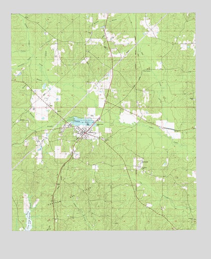
Chatham, LA USGS Topographic Map
Click on map above to begin viewing in our Map Viewer.

This topographic map contains these locations and features:
Feature Name Type Latitude Longitude GNIS ID View Map
Brooklyn (historical)Populated PlaceN32.2654°W92.3807°542273View Map
Brooklyn CemeteryCemeteryN32.2563°W92.3776°542274View Map
Brooklyn Methodist ChurchChurchN32.2563°W92.3779°553779View Map
Bullard BranchStreamN32.3729°W92.4160°533536View Map
ChathamPopulated PlaceN32.3063°W92.4504°553957View Map
Chatham CemeteryCemeteryN32.3029°W92.4382°541294View Map
Chatham Gas FieldOilfieldN32.2696°W92.4593°541295View Map
Chatham LakeReservoirN32.3126°W92.4512°553958View Map
Chatham Lake DamDamN32.3127°W92.4443°556702View Map
Chatham Post OfficePost OfficeN32.3061°W92.4509°1631542View Map
Chatham Volunteer Fire Department Ward3BuildingN32.3065°W92.4522°2673072View Map
Colston CreekStreamN32.3524°W92.4890°534055View Map
ConcordPopulated PlaceN32.3135°W92.4946°541292View Map
Concord CemeteryCemeteryN32.3145°W92.4889°542284View Map
Concord ChurchChurchN32.3140°W92.4896°534074View Map
Dalley (historical)Populated PlaceN32.3252°W92.4793°542306View Map
Edwards BranchStreamN32.3168°W92.4318°534770View Map
Flat CreekStreamN32.3046°W92.3951°534990View Map
Fourmile CreekStreamN32.3502°W92.4854°535069View Map
Ginney BranchStreamN32.3368°W92.4757°535236View Map
Henderson Jasper Elementary School (historical)SchoolN32.3108°W92.4641°542300View Map
Henson CemeteryCemeteryN32.3252°W92.3761°535631View Map
Jackson Parish Sheriff's OfficeBuildingN32.3067°W92.4521°2755355View Map
Jasper Henderson Head Start Center SchoolSchoolN32.3110°W92.4626°2462810View Map
Mount Mariah ChurchChurchN32.2913°W92.4110°542327View Map
Mount MoriahPopulated PlaceN32.2868°W92.4135°543496View Map
Mount Moriah CemeteryCemeteryN32.2865°W92.4124°541293View Map
Nash (historical)Populated PlaceN32.3649°W92.4368°542331View Map
Old Bethel CemeteryCemeteryN32.3549°W92.4351°532972View Map
Pool BranchStreamN32.3365°W92.4713°538331View Map
Salem Baptist ChurchChurchN32.3632°W92.4454°555954View Map
Salem CemeteryCemeteryN32.3635°W92.4457°542348View Map
Smith BranchStreamN32.2710°W92.4888°540740View Map
Town of ChathamCivilN32.3094°W92.4520°2406258View Map
Union Hall School (historical)SchoolN32.3643°W92.4454°542358View Map
Veal FarmLocaleN32.3252°W92.4793°542359View Map
Ward ThreeCivilN32.2840°W92.4135°545059View Map
Wood JunctionPopulated PlaceN32.3421°W92.4115°543793View Map
Wyatt CemeteryCemeteryN32.3207°W92.4855°540551View Map

Note: Coordinates in the location and feature list above are referenced to NAD83 datum.


Copyright (C) 2008-2025 Ryan Niemi / Sunset Dynamics ... All Rights Reserved