TopoQuest Logo
Do you find TopoQuest useful?
Help keep TopoQuest running and adding new maps/features by donating!
Bitcoin:  19c7KJd3qBynnjoSw5npx9KScwjBe4ifkT
Litecoin:  LXs6TkuXGGXo1vDsWCkWVdjQX94eUKd6ui
Home View Maps Find Maps Find Places Resources & Links


Chestnut Bluff, Tennessee Topographic Map

USGS Map Title: Chestnut Bluff, TN
USGS Map MRC: 35089G3
DRG (GeoTIFF) Download: o35089g3.tif


Neighboring USGS Topographic Map Quads:


  Fowlkes, TN  
35089H4
 

  Bonicord, TN  
35089H3
 

  Friendship, TN  
35089H2
 

  Gates, TN  
35089G4
 

  Chestnut Bluff, TN  
35089G3
 

  Maury City, TN  
35089G2
 

  Durhamville, TN  
35089F4
 

  Tibbs, TN  
35089F3
 

  Jones, TN  
35089F2


Map MRC Location:

N36°
W90°
N36°
W89°
H8 H7 H6 H5 H4 H3 H2 H1
G8 G7 G6 G5 G4 G3 G2 G1
F8 F7 F6 F5 F4 F3 F2 F1
E8 E7 E6 E5 E4 E3 E2 E1
D8 D7 D6 D5 D4 D3 D2 D1
C8 C7 C6 C5 C4 C3 C2 C1
B8 B7 B6 B5 B4 B3 B2 B1
A8 A7 A6 A5 A4 A3 A2 A1
N35°
W90°
N35°
W89°

Chestnut Bluff, TN USGS 1:24K Topographic Map Preview:
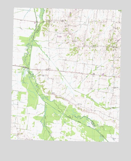
Chestnut Bluff, TN USGS Topographic Map
Click on map above to begin viewing in our Map Viewer.

This topographic map contains these locations and features:
Feature Name Type Latitude Longitude GNIS ID View Map
Albritton CemeteryCemeteryN35.8584°W89.3159°1275527View Map
Almores School (historical)SchoolN35.7942°W89.3270°1317636View Map
Antioch CemeteryCemeteryN35.8587°W89.2573°1275787View Map
Antioch Chapel (historical)ChurchN35.8579°W89.2576°1317637View Map
Archer ChapelChurchN35.8115°W89.3412°1326779View Map
Bear CreekStreamN35.8001°W89.3048°1276579View Map
Bettis CemeteryCemeteryN35.8537°W89.3265°1277190View Map
Bettis LakeLakeN35.8564°W89.3464°1277191View Map
Black CreekStreamN35.8451°W89.3509°1277562View Map
BroadviewPopulated PlaceN35.8398°W89.2598°1278437View Map
Brooks CemeteryCemeteryN35.8595°W89.3317°1278471View Map
Bucks ChapelChurchN35.8129°W89.2812°1278888View Map
Carter CemeteryCemeteryN35.8501°W89.3123°1279790View Map
Chestnut BluffPopulated PlaceN35.8626°W89.3331°1305884View Map
Chestnut Bluff BridgeBridgeN35.8626°W89.3398°1309863View Map
Commissioner District 2CivilN35.8482°W89.2954°2463910View Map
District 10 (historical)CivilN35.8167°W89.2834°1310250View Map
District 13 (historical)CivilN35.8584°W89.3001°1652419View Map
District 14 (historical)CivilN35.7834°W89.2584°1310253View Map
Dog HillPopulated PlaceN35.8409°W89.2831°1314956View Map
ElmorePopulated PlaceN35.7948°W89.3281°1315016View Map
Frog JumpPopulated PlaceN35.8167°W89.3353°1647228View Map
Frog Jump Volunteer Fire DepartmentBuildingN35.8164°W89.3329°2653819View Map
Gilliland SchoolSchoolN35.8173°W89.3345°1285418View Map
Glenn CemeteryCemeteryN35.8512°W89.3084°1285517View Map
Happy HollowValleyN35.8623°W89.2921°1286764View Map
Hellens Bluff SchoolSchoolN35.8637°W89.3190°1287339View Map
Island Number Eight (historical)IslandN35.8201°W89.3615°1309868View Map
Island Number Seven (historical)IslandN35.8320°W89.3565°1309870View Map
Island Number SixIslandN35.8734°W89.3420°1311104View Map
Lebanon ChurchChurchN35.8448°W89.3053°1290910View Map
Lick CreekStreamN35.8437°W89.3495°1291204View Map
Little Pond CreekStreamN35.8737°W89.2509°1269744View Map
Lost CreekStreamN35.7770°W89.3362°1292078View Map
Maury ChapelChurchN35.7845°W89.2984°1292964View Map
Maury City Division (historical)CensusN35.8212°W89.2523°1648663View Map
Moody LakeLakeN35.7524°W89.2565°1294217View Map
Nixon CreekStreamN35.7862°W89.3359°1295776View Map
Number Nine Island (historical)IslandN35.7695°W89.2828°1309869View Map
Perry School (historical)SchoolN35.8245°W89.3009°1317652View Map
Pond CreekStreamN35.7501°W89.3245°1298100View Map
Poplar Forest ChurchChurchN35.8009°W89.2570°1317653View Map
Poplar Forest SchoolSchoolN35.8004°W89.2567°1298188View Map
Poston CemeteryCemeteryN35.8128°W89.2812°1298322View Map
South Fork ChurchChurchN35.8640°W89.3215°1309872View Map
Tisdale CreekStreamN35.8556°W89.3492°1272692View Map
Wilson Mill (historical)LocaleN35.8723°W89.3442°1318138View Map
Young CemeteryCemeteryN35.8626°W89.3290°1275322View Map

Note: Coordinates in the location and feature list above are referenced to NAD83 datum.


Copyright (C) 2008-2024 Ryan Niemi / Sunset Dynamics ... All Rights Reserved