TopoQuest Logo
Do you find TopoQuest useful?
Help keep TopoQuest running and adding new maps/features by donating!
Bitcoin:  19c7KJd3qBynnjoSw5npx9KScwjBe4ifkT
Litecoin:  LXs6TkuXGGXo1vDsWCkWVdjQX94eUKd6ui
Home View Maps Find Maps Find Places Resources & Links


Bonicord, Tennessee Topographic Map

USGS Map Title: Bonicord, TN
USGS Map MRC: 35089H3
DRG (GeoTIFF) Download: o35089h3.tif


Neighboring USGS Topographic Map Quads:


  Dyersburg, TN  
36089A4
 

  Newbern, TN  
36089A3
 

  Tatumville, TN  
36089A2
 

  Fowlkes, TN  
35089H4
 

  Bonicord, TN  
35089H3
 

  Friendship, TN  
35089H2
 

  Gates, TN  
35089G4
 

  Chestnut Bluff, TN  
35089G3
 

  Maury City, TN  
35089G2


Map MRC Location:

N36°
W90°
N36°
W89°
H8 H7 H6 H5 H4 H3 H2 H1
G8 G7 G6 G5 G4 G3 G2 G1
F8 F7 F6 F5 F4 F3 F2 F1
E8 E7 E6 E5 E4 E3 E2 E1
D8 D7 D6 D5 D4 D3 D2 D1
C8 C7 C6 C5 C4 C3 C2 C1
B8 B7 B6 B5 B4 B3 B2 B1
A8 A7 A6 A5 A4 A3 A2 A1
N35°
W90°
N35°
W89°

Bonicord, TN USGS 1:24K Topographic Map Preview:
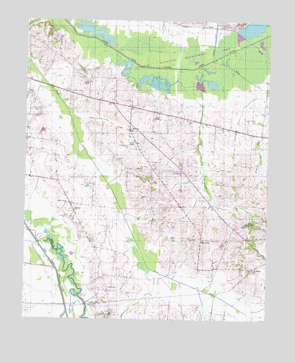
Bonicord, TN USGS Topographic Map
Click on map above to begin viewing in our Map Viewer.

This topographic map contains these locations and features:
Feature Name Type Latitude Longitude GNIS ID View Map
Beech GrovePopulated PlaceN35.9234°W89.3515°1647223View Map
Beech Grove ChurchChurchN35.9234°W89.3534°1305061View Map
BonicordPopulated PlaceN35.9545°W89.3217°1277951View Map
Bonicord Volunteer Fire DepartmentBuildingN35.9537°W89.3203°2653906View Map
BrucevillePopulated PlaceN35.9195°W89.3495°1310335View Map
Bruceville Volunteer Fire DepartmentBuildingN35.9226°W89.3510°2654178View Map
Cain CreekStreamN35.9595°W89.3520°1279292View Map
Clark Farm LakeReservoirN35.9535°W89.3666°1302221View Map
Clark Farm Lake DamDamN35.9534°W89.3651°1302220View Map
Clay CemeteryCemeteryN35.9762°W89.3456°1280628View Map
Commissioner District 1CivilN35.9627°W89.3291°2464228View Map
Cross RoadsPopulated PlaceN35.8867°W89.3317°1281710View Map
District 2 (historical)CivilN35.9542°W89.2959°1310256View Map
District 3 (historical)CivilN35.9209°W89.3584°1310257View Map
Eliza CreekStreamN35.9717°W89.2503°1283627View Map
Fowlkes Division (historical)CensusN35.9520°W89.3434°1648679View Map
Halls CreekStreamN35.8779°W89.3520°1269617View Map
HawkinsvillePopulated PlaceN35.9084°W89.2840°1315206View Map
Hillcrest School (historical)SchoolN35.9112°W89.3426°1316130View Map
Hodge CemeteryCemeteryN35.9837°W89.3531°1287946View Map
Holly Spring CemeteryCemeteryN35.9623°W89.3684°1288110View Map
Island Number Five (historical)IslandN35.9076°W89.3653°1309837View Map
Jones CemeteryCemeteryN35.9553°W89.2745°1289740View Map
Miller ChapelChurchN35.9487°W89.3190°1293936View Map
Miller Chapel CemeteryCemeteryN35.9387°W89.3165°1293939View Map
Mount Moriah ChurchChurchN35.8956°W89.2567°1294678View Map
Mount Pisgah CemeteryCemeteryN35.9162°W89.2901°1294736View Map
Nash CemeteryCemeteryN35.9251°W89.2820°1295242View Map
Nash CreekStreamN35.9759°W89.2898°1295245View Map
Palestine CemeteryCemeteryN35.9181°W89.3534°1296680View Map
Palestine ChurchChurchN35.9206°W89.3495°1296684View Map
ParkerPopulated PlaceN35.9978°W89.2831°1315677View Map
Parker DitchCanalN35.9970°W89.2778°1296822View Map
Parrish ChapelChurchN35.9592°W89.3092°1296881View Map
Saint Peter CemeteryCemeteryN35.9617°W89.2517°1300512View Map
Shelton CemeteryCemeteryN35.9415°W89.3278°1270018View Map
Sorrell ChapelChurchN35.9737°W89.3428°1270828View Map
Sorrell Chapel CemeteryCemeteryN35.9776°W89.3456°1270829View Map
Stokes CreekStreamN35.9915°W89.2592°1271466View Map
Tigrett Wildlife Management AreaParkN35.9834°W89.2917°1309852View Map
Walker CemeteryCemeteryN35.9581°W89.2915°1273599View Map
Williams Chapel CemeteryCemeteryN35.9473°W89.3223°1274691View Map
Zion Hill ChurchChurchN35.9090°W89.2901°1304734View Map

Note: Coordinates in the location and feature list above are referenced to NAD83 datum.


Copyright (C) 2008-2024 Ryan Niemi / Sunset Dynamics ... All Rights Reserved