TopoQuest Logo
Do you find TopoQuest useful?
Help keep TopoQuest running and adding new maps/features by donating!
Bitcoin:  19c7KJd3qBynnjoSw5npx9KScwjBe4ifkT
Litecoin:  LXs6TkuXGGXo1vDsWCkWVdjQX94eUKd6ui
Home View Maps Find Maps Find Places Resources & Links


Gates, Tennessee Topographic Map

USGS Map Title: Gates, TN
USGS Map MRC: 35089G4
DRG (GeoTIFF) Download: o35089g4.tif


Neighboring USGS Topographic Map Quads:


  Knob Creek, TN  
35089H5
 

  Fowlkes, TN  
35089H4
 

  Bonicord, TN  
35089H3
 

  Ripley North, TN  
35089G5
 

  Gates, TN  
35089G4
 

  Chestnut Bluff, TN  
35089G3
 

  Ripley South, TN  
35089F5
 

  Durhamville, TN  
35089F4
 

  Tibbs, TN  
35089F3


Map MRC Location:

N36°
W90°
N36°
W89°
H8 H7 H6 H5 H4 H3 H2 H1
G8 G7 G6 G5 G4 G3 G2 G1
F8 F7 F6 F5 F4 F3 F2 F1
E8 E7 E6 E5 E4 E3 E2 E1
D8 D7 D6 D5 D4 D3 D2 D1
C8 C7 C6 C5 C4 C3 C2 C1
B8 B7 B6 B5 B4 B3 B2 B1
A8 A7 A6 A5 A4 A3 A2 A1
N35°
W90°
N35°
W89°

Gates, TN USGS 1:24K Topographic Map Preview:
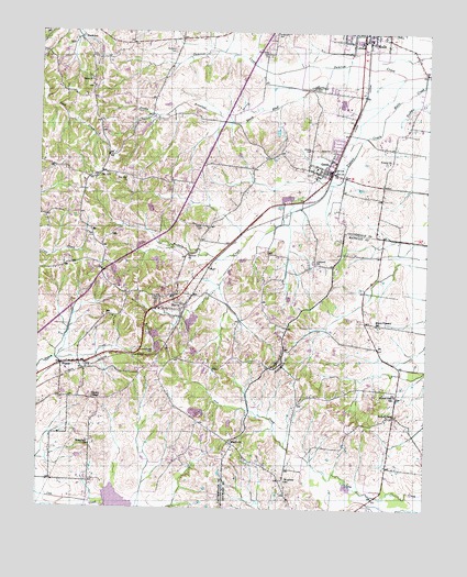
Gates, TN USGS Topographic Map
Click on map above to begin viewing in our Map Viewer.

This topographic map contains these locations and features:
Feature Name Type Latitude Longitude GNIS ID View Map
Abernathy (historical)Populated PlaceN35.8062°W89.4723°1311077View Map
Antioch ChurchChurchN35.8167°W89.4520°1275804View Map
Beech BluffStreamN35.8662°W89.4065°1276790View Map
Beech Bluff CemeteryCemeteryN35.8603°W89.4117°1276791View Map
Brownsville - Haywood County Fire Department District 6BuildingN35.7777°W89.3849°2654220View Map
Cane Creek Watershed Dam Fourteen ADamN35.7517°W89.4867°1302110View Map
Carter CemeteryCemeteryN35.8237°W89.4478°1279789View Map
Commissioner District 7CivilN35.8569°W89.4922°2464624View Map
Concord ChurchChurchN35.8148°W89.4109°1281066View Map
Cross Roads School (historical)SchoolN35.7879°W89.4587°1318074View Map
Crossroads CemeteryCemeteryN35.7909°W89.4628°1281724View Map
CurvePopulated PlaceN35.8048°W89.4567°1281905View Map
Curve Baptist ChurchChurchN35.8037°W89.4556°1318075View Map
Curve Post Office (historical)Post OfficeN35.8034°W89.4531°1650947View Map
Curve School (historical)SchoolN35.8054°W89.4576°1318076View Map
Double BranchesStreamN35.8515°W89.4381°1282685View Map
Dry HillPopulated PlaceN35.8381°W89.4806°1314975View Map
Dry Hill ChurchChurchN35.8370°W89.4726°1282987View Map
Dunavant CemeteryCemeteryN35.8698°W89.4573°1283133View Map
East Lauderdale County Volunteer Fire DepartmentBuildingN35.8051°W89.4583°2653882View Map
Enon ChurchChurchN35.8620°W89.4837°1283812View Map
Eureka CemeteryCemeteryN35.7745°W89.3845°1318974View Map
Eureka ChurchChurchN35.7745°W89.3842°1318975View Map
FlippinPopulated PlaceN35.7873°W89.4929°1284495View Map
Flippin Post Office (historical)Post OfficeN35.7862°W89.4865°1650952View Map
Forked DeerPopulated PlaceN35.7742°W89.3851°1284634View Map
Forked Deer SchoolSchoolN35.7801°W89.3845°1284638View Map
GatesPopulated PlaceN35.8384°W89.4062°1285236View Map
Gates CemeteryCemeteryN35.8442°W89.4059°1285237View Map
Gates Division (historical)CensusN35.8417°W89.4612°1648814View Map
Gates Fire DepartmentBuildingN35.8383°W89.4067°2653942View Map
Gates Post OfficePost OfficeN35.8398°W89.4068°1650955View Map
Gates School (historical)SchoolN35.8395°W89.4109°1318088View Map
Halls Post OfficePost OfficeN35.8713°W89.3978°1650959View Map
Lauderdale County LandfillLocaleN35.8314°W89.4917°2677897View Map
Leggett CemeteryCemeteryN35.7890°W89.4367°1647457View Map
Lillian Fountain School (historical)SchoolN35.8401°W89.4140°1318110View Map
McKingons Store (historical)LocaleN35.8206°W89.3890°1318998View Map
Mount Pleasant ChurchChurchN35.7981°W89.3898°1319001View Map
Mount Pleasant SchoolSchoolN35.7984°W89.3909°1294785View Map
NankipooPopulated PlaceN35.8737°W89.4881°1295226View Map
Nelson ChapelChurchN35.7784°W89.4826°1295379View Map
Rhodes CemeteryCemeteryN35.8442°W89.4131°1299283View Map
Sunrow CreekStreamN35.8640°W89.3823°1271878View Map
Thurmand CemeteryCemeteryN35.8692°W89.4278°1304099View Map
Town of GatesCivilN35.8401°W89.4082°2406551View Map
Trinity ChurchChurchN35.8412°W89.3873°1272890View Map
Whitefield ChurchChurchN35.7665°W89.4837°1274408View Map
WoodvillePopulated PlaceN35.7667°W89.4367°1304676View Map
Woodville Baptist ChurchChurchN35.7634°W89.4334°1319033View Map
Woodville CemeteryCemeteryN35.7631°W89.4328°1319035View Map
Woodville Post Office (historical)Post OfficeN35.7667°W89.4365°1651146View Map
Woodville SchoolSchoolN35.7573°W89.4198°1275101View Map

Note: Coordinates in the location and feature list above are referenced to NAD83 datum.


Copyright (C) 2008-2025 Ryan Niemi / Sunset Dynamics ... All Rights Reserved