TopoQuest Logo
Do you find TopoQuest useful?
Help keep TopoQuest running and adding new maps/features by donating!
Bitcoin:  19c7KJd3qBynnjoSw5npx9KScwjBe4ifkT
Litecoin:  LXs6TkuXGGXo1vDsWCkWVdjQX94eUKd6ui
Home View Maps Find Maps Find Places Resources & Links


Fowlkes, Tennessee Topographic Map

USGS Map Title: Fowlkes, TN
USGS Map MRC: 35089H4
DRG (GeoTIFF) Download: o35089h4.tif


Neighboring USGS Topographic Map Quads:


  Caruthersville SE, TN  
36089A5
 

  Dyersburg, TN  
36089A4
 

  Newbern, TN  
36089A3
 

  Knob Creek, TN  
35089H5
 

  Fowlkes, TN  
35089H4
 

  Bonicord, TN  
35089H3
 

  Ripley North, TN  
35089G5
 

  Gates, TN  
35089G4
 

  Chestnut Bluff, TN  
35089G3


Map MRC Location:

N36°
W90°
N36°
W89°
H8 H7 H6 H5 H4 H3 H2 H1
G8 G7 G6 G5 G4 G3 G2 G1
F8 F7 F6 F5 F4 F3 F2 F1
E8 E7 E6 E5 E4 E3 E2 E1
D8 D7 D6 D5 D4 D3 D2 D1
C8 C7 C6 C5 C4 C3 C2 C1
B8 B7 B6 B5 B4 B3 B2 B1
A8 A7 A6 A5 A4 A3 A2 A1
N35°
W90°
N35°
W89°

Fowlkes, TN USGS 1:24K Topographic Map Preview:
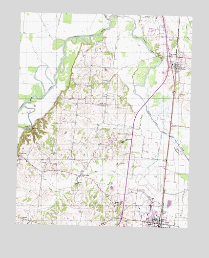
Fowlkes, TN USGS Topographic Map
Click on map above to begin viewing in our Map Viewer.

This topographic map contains these locations and features:
Feature Name Type Latitude Longitude GNIS ID View Map
Anderson CemeteryCemeteryN35.8751°W89.4242°1275703View Map
Anderson Chapel CemeteryCemeteryN35.8795°W89.4220°1275710View Map
Antioch ChurchChurchN35.9106°W89.4787°1275805View Map
Arnold FieldAirportN35.9068°W89.3976°1301376View Map
Benton SchoolSchoolN35.9701°W89.4390°1277031View Map
Bethesda ChurchChurchN35.8887°W89.4292°1277145View Map
Butterworth CemeteryCemeteryN35.9895°W89.3976°1279202View Map
Camp Number Seven (historical)LocaleN35.9256°W89.3804°1309782View Map
Chambers BranchStreamN35.9454°W89.4073°1280206View Map
Commissioner District 8CivilN35.8972°W89.4228°2464683View Map
District 12 (historical)CivilN35.9667°W89.3806°1310265View Map
District 13 (historical)CivilN35.9626°W89.4223°1310266View Map
Double BridgesPopulated PlaceN35.9051°W89.4537°1282689View Map
Double Bridges School (historical)SchoolN35.9070°W89.4515°1318077View Map
Dyersburg Army Air Field (historical)MilitaryN35.9017°W89.4017°2085470View Map
Dyersburg Regional AirportAirportN35.9991°W89.4021°1301387View Map
Edwards CreekStreamN35.9851°W89.4737°1309798View Map
Elon CemeteryCemeteryN35.9126°W89.4498°1283728View Map
Elon CHurchChurchN35.9073°W89.4512°1318081View Map
Four PointsPopulated PlaceN35.9762°W89.3909°1284719View Map
FowlkesPopulated PlaceN35.9706°W89.3862°1284753View Map
Fowlkes Baptist ChurchChurchN35.9690°W89.3892°1643397View Map
Fowlkes Volunteer Fire DepartmentBuildingN35.9750°W89.3902°2654180View Map
Fowlks Post OfficePost OfficeN35.9692°W89.3859°1650098View Map
HallsPopulated PlaceN35.8756°W89.3962°1286606View Map
Halls Division (historical)CensusN35.8862°W89.4159°1648815View Map
Halls Elementary SchoolSchoolN35.8823°W89.3979°1318098View Map
Halls Fire DepartmentBuildingN35.8757°W89.3951°2653885View Map
Halls First Baptist ChurchChurchN35.8776°W89.3956°1318099View Map
Halls High SchoolSchoolN35.8801°W89.4042°1318100View Map
Halls Police DepartmentBuildingN35.8752°W89.3946°2765764View Map
Hoffman Mill (historical)LocaleN35.9759°W89.3995°1309811View Map
Holice Powell Elementary SchoolSchoolN35.9715°W89.3887°1648469View Map
Island Number Four (historical)IslandN35.9434°W89.4031°1309836View Map
Island Number One (historical)IslandN35.9967°W89.4348°1309833View Map
Island Number Three (historical)IslandN35.9884°W89.4195°1309835View Map
Island Number Two (historical)IslandN35.9973°W89.4142°1309834View Map
Key CornerPopulated PlaceN35.9315°W89.4906°1315320View Map
King CemeteryCemeteryN35.9809°W89.3970°1290207View Map
McCoy CemeteryCemeteryN35.9537°W89.3828°1293205View Map
Mill CreekStreamN35.9315°W89.3956°1293844View Map
Mount Vernon ChurchChurchN35.9601°W89.4348°1294828View Map
Mount Zion ChurchChurchN35.8998°W89.4565°1294896View Map
Nankipoo School (historical)SchoolN35.8759°W89.4906°1318118View Map
North Fork Forked Deer RiverStreamN35.9973°W89.4356°1295887View Map
Parr CemeteryCemeteryN35.9123°W89.4248°1296874View Map
Poplar GrovePopulated PlaceN35.9298°W89.4215°1315757View Map
Poplar Grove ChurchChurchN35.9262°W89.4217°1298197View Map
Porter GapPopulated PlaceN35.9154°W89.4973°1298261View Map
Rutherford CemeteryCemeteryN35.9176°W89.4745°1300354View Map
South ForkPopulated PlaceN35.9359°W89.3892°1314311View Map
South Fork Forked Deer RiverStreamN35.9976°W89.4356°1270865View Map
Town of HallsCivilN35.8794°W89.4047°2406638View Map
UnionvillePopulated PlaceN35.9517°W89.4362°1273263View Map
Unionville Academy (historical)SchoolN35.9501°W89.4373°1309855View Map
Williams ChapelChurchN35.9259°W89.4229°1304603View Map
Yellow BluffCliffN35.9765°W89.3995°1309857View Map
Yellow Bluff BridgeBridgeN35.9762°W89.4009°1309858View Map

Note: Coordinates in the location and feature list above are referenced to NAD83 datum.


Copyright (C) 2008-2024 Ryan Niemi / Sunset Dynamics ... All Rights Reserved