TopoQuest Logo
Do you find TopoQuest useful?
Help keep TopoQuest running and adding new maps/features by donating!
Bitcoin:  19c7KJd3qBynnjoSw5npx9KScwjBe4ifkT
Litecoin:  LXs6TkuXGGXo1vDsWCkWVdjQX94eUKd6ui
Home View Maps Find Maps Find Places Resources & Links


Chincoteague East, Virginia Topographic Map

USGS Map Title: Chincoteague East, VA
USGS Map MRC: 37075H3
DRG (GeoTIFF) Download: o37075h3.tif


Neighboring USGS Topographic Map Quads:


  Girdletree, MD  
38075A4
 

  Boxiron, MD  
38075A3
 

  Whittington Point, MD  
38075A2
 

  Chincoteague West, VA  
37075H4
 

  Chincoteague East, VA  
37075H3


  Wallops Island, VA  
37075G4


Map MRC Location:

N38°
W76°
N38°
W75°
H8 H7 H6 H5 H4 H3 H2 H1
G8 G7 G6 G5 G4 G3 G2 G1
F8 F7 F6 F5 F4 F3 F2 F1
E8 E7 E6 E5 E4 E3 E2 E1
D8 D7 D6 D5 D4 D3 D2 D1
C8 C7 C6 C5 C4 C3 C2 C1
B8 B7 B6 B5 B4 B3 B2 B1
A8 A7 A6 A5 A4 A3 A2 A1
N37°
W76°
N37°
W75°

Chincoteague East, VA USGS 1:24K Topographic Map Preview:
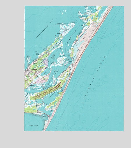
Chincoteague East, VA USGS Topographic Map
Click on map above to begin viewing in our Map Viewer.

This topographic map contains these locations and features:
Feature Name Type Latitude Longitude GNIS ID View Map
Archie CoveBayN37.9635°W75.3394°1462548View Map
Assateague BayBayN37.9718°W75.3127°1462601View Map
Assateague CemeteryCemeteryN37.9153°W75.3496°2780625View Map
Assateague ChannelChannelN37.9265°W75.3416°1462602View Map
Assateague LighthouseLocaleN37.9112°W75.3558°1779633View Map
Assateague Village CemeteryCemeteryN37.9129°W75.3536°2780626View Map
Birch Family CemeteryCemeteryN37.9225°W75.3694°2780420View Map
Birch TownPopulated PlaceN37.9204°W75.3685°1492577View Map
Black Duck MarshSwampN37.9041°W75.3709°1463483View Map
Blake CoveBayN37.9515°W75.3566°1463546View Map
Blake PointCapeN37.9526°W75.3569°1463547View Map
Booths BayBayN37.9718°W75.3277°1463676View Map
Bow BeachBeachN37.9468°W75.3135°1463701View Map
Calfpen BayBayN37.9998°W75.2935°1464251View Map
Carrs MarshSwampN37.9340°W75.3255°1464464View Map
Carter CemeteryCemeteryN37.9335°W75.3559°2780428View Map
Chandler CemeteryCemeteryN37.9545°W75.3442°2780425View Map
Cherrytree HillSummitN37.9871°W75.2996°1492750View Map
Cherrytree Hill BayBayN37.9907°W75.2996°1464793View Map
Chincoteague Elementary SchoolSchoolN37.9379°W75.3579°1779640View Map
Chincoteague High SchoolSchoolN37.9428°W75.3638°1464859View Map
Chincoteague IslandIslandN37.9385°W75.3616°1464860View Map
Chincoteague Island Post OfficePost OfficeN37.9345°W75.3747°1779641View Map
Chincoteague Police DepartmentBuildingN37.9362°W75.3608°2075668View Map
Christ Sanctified Holy ChurchChurchN37.9468°W75.3585°1464884View Map
Coards MarshesSwampN37.9923°W75.3272°1477908View Map
Daisey Memorial CemeteryCemeteryN37.9262°W75.3663°2780418View Map
Deep HolePopulated PlaceN37.9373°W75.3533°1492853View Map
Deep Hole CreekStreamN37.9351°W75.3496°1465704View Map
District 1CivilN37.9285°W75.3159°1927175View Map
East GutGutN37.9646°W75.3271°1466106View Map
Eel CreekStreamN37.9312°W75.3538°1466191View Map
Greenbank BayBayN37.9946°W75.3019°1467491View Map
Hairy Head PondLakeN37.9595°W75.3340°1467640View Map
Harmon CoveBayN37.9823°W75.3232°1467754View Map
Hill CemeteryCemeteryN37.9389°W75.3476°2780427View Map
Holly Ridge CemeteryCemeteryN37.9450°W75.3606°1473202View Map
Island Family MedicineHospitalN37.9321°W75.3604°1779649View Map
Janeys CreekStreamN37.9201°W75.3416°1468642View Map
Janeys Creek MarshSwampN37.9252°W75.3378°1468643View Map
Jim Blades PointCapeN37.9443°W75.3199°1468746View Map
Jones CemeteryCemeteryN37.9242°W75.3745°2780417View Map
Lighthouse Christian AcademySchoolN37.9275°W75.3539°2465155View Map
Little Harmon CoveBayN37.9823°W75.3294°1469558View Map
Little Morris Island CreekStreamN37.9407°W75.3258°1469598View Map
Little Oyster BayBayN37.9340°W75.3488°1469610View Map
Little Toms CoveBayN37.8876°W75.3483°1469673View Map
Mechanics CemeteryCemeteryN37.9263°W75.3663°1470333View Map
Mink Tump PointCapeN37.9801°W75.3283°1470612View Map
Morris IslandIslandN37.9446°W75.3288°1470762View Map
Morris Island CreekStreamN37.9496°W75.3327°1470763View Map
Oyster BayBayN37.9512°W75.3371°1472007View Map
Peach CreekStreamN37.9832°W75.2996°1472146View Map
Piney IslandIslandN37.9254°W75.3538°1472405View Map
Ragged Point MarshesSwampN37.9895°W75.2956°1472937View Map
Ragged Point TrailTrailN37.9935°W75.2827°1472938View Map
Red Mens CemeteryCemeteryN37.9384°W75.3696°1473078View Map
Reed CemeteryCemeteryN37.9353°W75.3531°2780426View Map
Reynolds CemeteryCemeteryN37.9250°W75.3682°2780419View Map
Saint Andrew Catholic Church CemeteryCemeteryN37.9329°W75.3742°2780422View Map
Sheepshead CreekStreamN37.9173°W75.3708°1474464View Map
Sign GutGutN37.9790°W75.3149°1474579View Map
Silver LakeReservoirN37.9469°W75.3233°587367View Map
Smalley DrainGutN37.9115°W75.3716°1474708View Map
Smith BayBayN37.9796°W75.3010°1474715View Map
Smith Bay TumpsCapeN37.9818°W75.3007°1474716View Map
Smith HammocksIslandN37.9640°W75.3113°1474753View Map
Taylor CemeteryCemeteryN37.9345°W75.3726°2780423View Map
The Will HoleChannelN37.9960°W75.2827°1475620View Map
Thurf Marsh IslandsIslandN37.9643°W75.3171°1475699View Map
Toms CoveBayN37.8779°W75.3663°1475775View Map
Town of ChincoteagueCivilN37.9499°W75.3532°2390792View Map
Union Baptist Church CemeteryCemeteryN37.9328°W75.3703°2780429View Map
Vineyard ShoalBarN37.9585°W75.3483°1476197View Map
Virginia Lifeline Ambulance ServiceBuildingN37.9354°W75.3650°2660587View Map
Whealton - Clayville CemeteryCemeteryN37.9411°W75.3656°2780424View Map
Wildcat GutGutN37.9732°W75.3191°1476715View Map
Wildcat MarshSwampN37.9786°W75.3221°1476720View Map
Wildcat PointCapeN37.9826°W75.3132°1476721View Map
Woods GroveWoodsN37.9607°W75.3283°1476969View Map

Note: Coordinates in the location and feature list above are referenced to NAD83 datum.


Copyright (C) 2008-2024 Ryan Niemi / Sunset Dynamics ... All Rights Reserved