TopoQuest Logo
Do you find TopoQuest useful?
Help keep TopoQuest running and adding new maps/features by donating!
Bitcoin:  19c7KJd3qBynnjoSw5npx9KScwjBe4ifkT
Litecoin:  LXs6TkuXGGXo1vDsWCkWVdjQX94eUKd6ui
Home View Maps Find Maps Find Places Resources & Links


Clanton East, Alabama Topographic Map

USGS Map Title: Clanton East, AL
USGS Map MRC: 32086G5
DRG (GeoTIFF) Download: o32086g5.tif


Neighboring USGS Topographic Map Quads:


  Jemison East, AL  
32086H6
 

  Lay Dam, AL  
32086H5
 

  Mitchell Dam NW, AL  
32086H4
 

  Clanton West, AL  
32086G6
 

  Clanton East, AL  
32086G5
 

  Mitchell Dam, AL  
32086G4
 

  Billingsley, AL  
32086F6
 

  White City, AL  
32086F5
 

  Marbury, AL  
32086F4


Map MRC Location:

N33°
W87°
N33°
W86°
H8 H7 H6 H5 H4 H3 H2 H1
G8 G7 G6 G5 G4 G3 G2 G1
F8 F7 F6 F5 F4 F3 F2 F1
E8 E7 E6 E5 E4 E3 E2 E1
D8 D7 D6 D5 D4 D3 D2 D1
C8 C7 C6 C5 C4 C3 C2 C1
B8 B7 B6 B5 B4 B3 B2 B1
A8 A7 A6 A5 A4 A3 A2 A1
N32°
W87°
N32°
W86°

Clanton East, AL USGS 1:24K Topographic Map Preview:
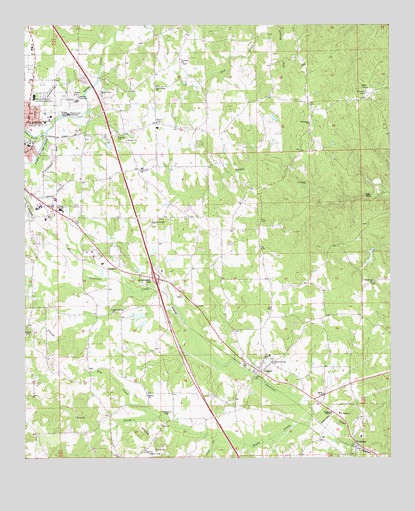
Clanton East, AL USGS Topographic Map
Click on map above to begin viewing in our Map Viewer.

This topographic map contains these locations and features:
Feature Name Type Latitude Longitude GNIS ID View Map
Adair SchoolSchoolN32.8404°W86.6236°112914View Map
Aldridge Family CemeteryCemeteryN32.7968°W86.5714°2062898View Map
Bethel CemeteryCemeteryN32.7682°W86.5836°151477View Map
Bethel Primitive Baptist ChurchChurchN32.7682°W86.5833°151677View Map
Big RockIslandN32.8265°W86.5094°114313View Map
Big Spring ChurchChurchN32.8010°W86.5055°114324View Map
Chestnut Creek Baptist ChurchChurchN32.7782°W86.5405°116017View Map
Chestnut Creek CemeteryCemeteryN32.7787°W86.5408°136664View Map
Chestnut Post Office (historical)Post OfficeN32.7662°W86.5055°166062View Map
Chilton County AirportAirportN32.8495°W86.6098°129448View Map
Chilton County High SchoolSchoolN32.8218°W86.6125°136666View Map
Chilton County Memorial GardensCemeteryN32.8550°W86.6114°151481View Map
Chilton Medical CenterHospitalN32.8546°W86.6218°136667View Map
City of ClantonCivilN32.8417°W86.6230°2404052View Map
Clanton CemeteryCemeteryN32.8418°W86.6241°136671View Map
Clanton DivisionCivilN32.8514°W86.6024°165690View Map
Clanton Fire and Rescue Department Station 2BuildingN32.8042°W86.5894°2691494View Map
Clanton Golf and Country ClubLocaleN32.8229°W86.6069°136674View Map
Clear CreekStreamN32.7551°W86.5603°116235View Map
Clearview Mission ChurchChurchN32.7651°W86.5236°149484View Map
Concord Baptist ChurchChurchN32.8429°W86.5939°151736View Map
Concord CemeteryCemeteryN32.8429°W86.5933°151480View Map
CooperPopulated PlaceN32.7751°W86.5455°157924View Map
Cooper SchoolSchoolN32.7807°W86.5422°136678View Map
Cross Roads Church (historical)ChurchN32.8007°W86.5416°136680View Map
Dry CreekStreamN32.7618°W86.5797°117536View Map
East Chilton Volunteer Fire and RescueBuildingN32.8533°W86.5320°2691172View Map
Eastview CemeteryCemeteryN32.7515°W86.5833°149486View Map
FalaktoPopulated PlaceN32.8048°W86.5941°118170View Map
Glad Tidings CemeteryCemeteryN32.8573°W86.5800°151482View Map
Glad Tidings Church of ChristChurchN32.8571°W86.5814°151785View Map
Goldwaithe and Walkers Goldmine (historical)MineN32.7771°W86.5136°136685View Map
Goose Pond CreekStreamN32.8448°W86.6183°119165View Map
Grantville (historical)LocaleN32.8668°W86.6055°136687View Map
Interchange 205CrossingN32.8018°W86.5803°155590View Map
Interchange 208CrossingN32.8432°W86.5953°155591View Map
J T Stewart Lake DamDamN32.8085°W86.5816°131029View Map
Maple Springs Baptist ChurchChurchN32.7921°W86.5950°152220View Map
Maple Springs CemeteryCemeteryN32.7915°W86.5950°151579View Map
Mount Pisgah Church (historical)ChurchN32.8671°W86.6208°136703View Map
Oak Grove Church of God CemeteryCemeteryN32.8248°W86.5503°2062895View Map
Old Bethel CemeteryCemeteryN32.7640°W86.5769°152766View Map
Poley Bridge CreekStreamN32.8446°W86.6175°125100View Map
Poplar Springs Baptist ChurchChurchN32.8182°W86.5819°153041View Map
Poplar Springs CemeteryCemeteryN32.8193°W86.5794°151478View Map
Popwell CemeteryCemeteryN32.8062°W86.5994°2062896View Map
Providence Baptist ChurchChurchN32.8468°W86.5280°153080View Map
Providence CemeteryCemeteryN32.8473°W86.5269°151484View Map
Shelton Barkley LakeReservoirN32.7890°W86.5846°131023View Map
Shelton Barkley Lake DamDamN32.7901°W86.5850°131024View Map
South Prong Chestnut CreekStreamN32.7629°W86.5258°153506View Map
Sunshine Assembly of God ChurchChurchN32.8643°W86.5730°153613View Map
Sunshine CemeteryCemeteryN32.8640°W86.5714°151483View Map
T J Stewart LakeReservoirN32.8096°W86.5811°131028View Map
Temple Assembly of God ChurchChurchN32.8335°W86.5855°153667View Map
Temple CemeteryCemeteryN32.8340°W86.5841°151479View Map
Thomas Junior High SchoolSchoolN32.8037°W86.5883°136717View Map
Tiger StadiumParkN32.8222°W86.6108°2352835View Map
Verbena Baptist ChurchChurchN32.7507°W86.5158°154299View Map
Verbena CemeteryCemeteryN32.7554°W86.5236°151485View Map
Verbena DivisionCivilN32.7596°W86.5259°165695View Map
Verbena Junior High SchoolSchoolN32.7629°W86.5175°136725View Map
Verbena Post OfficePost OfficeN32.7534°W86.5110°2789073View Map
Verbena Volunteer Fire and Rescue 16BuildingN32.7529°W86.5105°2691219View Map
Walnut Creek CemeteryCemeteryN32.8543°W86.5980°136726View Map
Walnut Creek Methodist ChurchChurchN32.8546°W86.5991°153879View Map

Note: Coordinates in the location and feature list above are referenced to NAD83 datum.


Copyright (C) 2008-2025 Ryan Niemi / Sunset Dynamics ... All Rights Reserved