TopoQuest Logo
Do you find TopoQuest useful?
Help keep TopoQuest running and adding new maps/features by donating!
Bitcoin:  19c7KJd3qBynnjoSw5npx9KScwjBe4ifkT
Litecoin:  LXs6TkuXGGXo1vDsWCkWVdjQX94eUKd6ui
Home View Maps Find Maps Find Places Resources & Links


Billingsley, Alabama Topographic Map

USGS Map Title: Billingsley, AL
USGS Map MRC: 32086F6
DRG (GeoTIFF) Download: o32086f6.tif


Neighboring USGS Topographic Map Quads:


  Maplesville East, AL  
32086G7
 

  Clanton West, AL  
32086G6
 

  Clanton East, AL  
32086G5
 

  Pletcher, AL  
32086F7
 

  Billingsley, AL  
32086F6
 

  White City, AL  
32086F5
 

  Milton, AL  
32086E7
 

  Vida, AL  
32086E6
 

  Old Kingston, AL  
32086E5


Map MRC Location:

N33°
W87°
N33°
W86°
H8 H7 H6 H5 H4 H3 H2 H1
G8 G7 G6 G5 G4 G3 G2 G1
F8 F7 F6 F5 F4 F3 F2 F1
E8 E7 E6 E5 E4 E3 E2 E1
D8 D7 D6 D5 D4 D3 D2 D1
C8 C7 C6 C5 C4 C3 C2 C1
B8 B7 B6 B5 B4 B3 B2 B1
A8 A7 A6 A5 A4 A3 A2 A1
N32°
W87°
N32°
W86°

Billingsley, AL USGS 1:24K Topographic Map Preview:
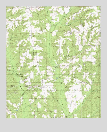
Billingsley, AL USGS Topographic Map
Click on map above to begin viewing in our Map Viewer.

This topographic map contains these locations and features:
Feature Name Type Latitude Longitude GNIS ID View Map
Antioch CemeteryCemeteryN32.7379°W86.7291°151495View Map
Bee BranchStreamN32.7351°W86.6503°113794View Map
Bethsalem Baptist ChurchChurchN32.7215°W86.6655°151682View Map
Bethsalem CemeteryCemeteryN32.7210°W86.6669°151498View Map
BillingsleyPopulated PlaceN32.6596°W86.7178°151686View Map
Billingsley CemeteryCemeteryN32.6618°W86.7208°149480View Map
Billingsley ChurchChurchN32.6610°W86.6522°147532View Map
Billingsley High SchoolSchoolN32.6590°W86.7036°147533View Map
Billingsley Post OfficePost OfficeN32.6599°W86.7182°167087View Map
Billingsley Volunteer Fire DepartmentBuildingN32.6649°W86.7032°2691540View Map
Carter CemeteryCemeteryN32.6301°W86.7394°147541View Map
Cowwild BranchStreamN32.7287°W86.6825°116774View Map
Fall Line HillsRangeN32.6668°W86.6666°148951View Map
HaynesPopulated PlaceN32.6257°W86.6730°119899View Map
Hinton CemeteryCemeteryN32.6318°W86.6905°120150View Map
Hurricane BranchStreamN32.7018°W86.7486°120571View Map
Indian CreekStreamN32.6793°W86.6833°120646View Map
Indian Grave ChurchChurchN32.6826°W86.6514°120655View Map
Kincheon CreekStreamN32.7260°W86.6891°121205View Map
Moores Mill (historical)LocaleN32.6990°W86.7044°147593View Map
Mount Zion ChurchChurchN32.6787°W86.7289°123469View Map
MulberryPopulated PlaceN32.6710°W86.7175°123571View Map
New Cedron Baptist ChurchChurchN32.7176°W86.7158°123735View Map
New Cedron CemeteryCemeteryN32.7171°W86.7164°151497View Map
New Harmony CemeteryCemeteryN32.7383°W86.7287°151496View Map
New Harmony Holiness ChurchChurchN32.7379°W86.7286°152621View Map
New Home ChurchChurchN32.7485°W86.7417°123770View Map
New Mount Zion ChurchChurchN32.6782°W86.7319°136706View Map
Old Cedron Church (historical)ChurchN32.7193°W86.7161°136708View Map
Pierce BranchStreamN32.7101°W86.6408°124705View Map
Pleasant Hill ChurchChurchN32.6854°W86.6464°152995View Map
Pools CrossroadsPopulated PlaceN32.7487°W86.7194°125133View Map
Simmons BranchStreamN32.7201°W86.6925°126864View Map
Talley BranchStreamN32.7499°W86.6964°127650View Map
Town of BillingsleyCivilN32.6606°W86.7104°2405265View Map
Wheatley BranchStreamN32.6557°W86.6772°128825View Map
White Water LakeReservoirN32.6318°W86.6394°147672View Map

Note: Coordinates in the location and feature list above are referenced to NAD83 datum.


Copyright (C) 2008-2025 Ryan Niemi / Sunset Dynamics ... All Rights Reserved