TopoQuest Logo
Do you find TopoQuest useful?
Help keep TopoQuest running and adding new maps/features by donating!
Bitcoin:  19c7KJd3qBynnjoSw5npx9KScwjBe4ifkT
Litecoin:  LXs6TkuXGGXo1vDsWCkWVdjQX94eUKd6ui
Home View Maps Find Maps Find Places Resources & Links


Clanton West, Alabama Topographic Map

USGS Map Title: Clanton West, AL
USGS Map MRC: 32086G6
DRG (GeoTIFF) Download: o32086g6.tif


Neighboring USGS Topographic Map Quads:


  Jemison West, AL  
32086H7
 

  Jemison East, AL  
32086H6
 

  Lay Dam, AL  
32086H5
 

  Maplesville East, AL  
32086G7
 

  Clanton West, AL  
32086G6
 

  Clanton East, AL  
32086G5
 

  Pletcher, AL  
32086F7
 

  Billingsley, AL  
32086F6
 

  White City, AL  
32086F5


Map MRC Location:

N33°
W87°
N33°
W86°
H8 H7 H6 H5 H4 H3 H2 H1
G8 G7 G6 G5 G4 G3 G2 G1
F8 F7 F6 F5 F4 F3 F2 F1
E8 E7 E6 E5 E4 E3 E2 E1
D8 D7 D6 D5 D4 D3 D2 D1
C8 C7 C6 C5 C4 C3 C2 C1
B8 B7 B6 B5 B4 B3 B2 B1
A8 A7 A6 A5 A4 A3 A2 A1
N32°
W87°
N32°
W86°

Clanton West, AL USGS 1:24K Topographic Map Preview:
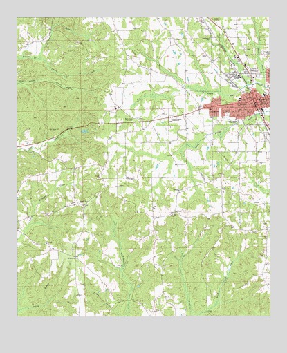
Clanton West, AL USGS Topographic Map
Click on map above to begin viewing in our Map Viewer.

This topographic map contains these locations and features:
Feature Name Type Latitude Longitude GNIS ID View Map
Black Snake CreekStreamN32.8460°W86.6275°114434View Map
Caney BranchStreamN32.8579°W86.7400°115565View Map
Central Alabama Hospital (historical)HospitalN32.8401°W86.6375°136663View Map
Chilton CountyCivilN32.8479°W86.7188°161536View Map
Chilton County CourthouseBuildingN32.8398°W86.6297°136665View Map
Chilton County Industrial School (historical)SchoolN32.7898°W86.6816°136668View Map
Chilton County SheriffBuildingN32.8404°W86.6299°2751747View Map
Chilton County Vocational Skills CenterSchoolN32.8321°W86.6583°136669View Map
Chilton County Vocational Technical SchoolSchoolN32.8323°W86.6736°136670View Map
ClantonPopulated PlaceN32.8387°W86.6294°157918View Map
Clanton City HallBuildingN32.8396°W86.6297°136672View Map
Clanton Drive-In (historical)LocaleN32.8725°W86.6506°2710706View Map
Clanton Elementary SchoolSchoolN32.8407°W86.6400°136673View Map
Clanton Fire and Rescue Department Station 1BuildingN32.8382°W86.6289°2691234View Map
Clanton Police DepartmentBuildingN32.8384°W86.6297°2752079View Map
Clanton Post OfficePost OfficeN32.8319°W86.6270°167072View Map
Clanton Presbyterian ChurchChurchN32.8396°W86.6400°151474View Map
Eastview ChurchChurchN32.8010°W86.6397°149487View Map
Eiland BranchStreamN32.8576°W86.7400°117894View Map
Enterprise Volunteer Fire and Rescue Station 2BuildingN32.7833°W86.6258°2691523View Map
FairviewPopulated PlaceN32.7746°W86.7214°156334View Map
Fairview Church (historical)ChurchN32.8654°W86.7183°136684View Map
Fairview Fire and Rescue 8BuildingN32.7875°W86.7169°2691094View Map
First Baptist ChurchChurchN32.8401°W86.6300°154135View Map
First United Methodist ChurchChurchN32.8390°W86.6341°154136View Map
Friendship Baptist ChurchChurchN32.8598°W86.6255°151782View Map
Friendship CemeteryCemeteryN32.8598°W86.6253°151476View Map
HighlandPopulated PlaceN32.7932°W86.6733°120073View Map
Highland Baptist ChurchChurchN32.8029°W86.6705°151806View Map
Highland CemeteryCemeteryN32.8032°W86.6697°151502View Map
Highland Church of GodChurchN32.7926°W86.6733°154134View Map
Hopewell Baptist ChurchChurchN32.8140°W86.6297°151815View Map
Hopewell CemeteryCemeteryN32.8137°W86.6305°151472View Map
Ikanatchaka (historical)LocaleN32.8654°W86.7208°158139View Map
Isabella-Pletcher DivisionCivilN32.7724°W86.7383°165691View Map
KincheonPopulated PlaceN32.7571°W86.7019°156557View Map
Liberty Hill Baptist ChurchChurchN32.8371°W86.7022°152054View Map
Liberty Hill CemeteryCemeteryN32.8368°W86.7016°151499View Map
Martin Memorial CemeteryCemeteryN32.8622°W86.6367°122334View Map
Morning Star CemeteryCemeteryN32.8076°W86.6922°151501View Map
Morning Star ChurchChurchN32.8079°W86.6933°123064View Map
Mount Nebo CemeteryCemeteryN32.7812°W86.7355°151506View Map
Mount Nebo ChurchChurchN32.7812°W86.7358°123272View Map
Mount Pisgah Methodist ChurchChurchN32.7876°W86.6258°152485View Map
Mount Pisgah-Zion Ridge CemeteryCemeteryN32.7862°W86.6255°149498View Map
Mount Pleasant Baptist ChurchChurchN32.8660°W86.6739°152496View Map
Mount Pleasant Baptist Church CemeteryCemeteryN32.8664°W86.6725°151471View Map
New Bethel CemeteryCemeteryN32.8662°W86.6550°123715View Map
Old Liberty Hill CemeteryCemeteryN32.8271°W86.7322°124219View Map
Old Mount Nebo CemeteryCemeteryN32.7923°W86.7350°124231View Map
Peach CemeteryCemeteryN32.8082°W86.6922°151500View Map
Pleasant Grove CemeteryCemeteryN32.7976°W86.7194°151505View Map
Pleasant Grove Methodist ChurchChurchN32.7973°W86.7192°152977View Map
Resurrection Catholic ChurchChurchN32.8401°W86.6266°151475View Map
SamariaPopulated PlaceN32.8190°W86.6319°136714View Map
Samaria Baptist ChurchChurchN32.8185°W86.6314°153308View Map
Samaria CemeteryCemeteryN32.8190°W86.6330°151473View Map
Shiloh Baptist Church CemeteryCemeteryN32.7557°W86.6900°2062897View Map
Shiloh CemeteryCemeteryN32.7560°W86.6900°151504View Map
Shiloh ChurchChurchN32.7554°W86.6889°126744View Map
Victory ChapelChurchN32.8587°W86.6569°128447View Map
West End Baptist ChurchChurchN32.8365°W86.6541°136728View Map
WEZZ-FM (Clanton)TowerN32.8357°W86.6803°161168View Map
WKLF-AM (Clanton)TowerN32.8357°W86.6803°160983View Map
Zion Ridge ChurchChurchN32.7835°W86.6264°129359View Map

Note: Coordinates in the location and feature list above are referenced to NAD83 datum.


Copyright (C) 2008-2025 Ryan Niemi / Sunset Dynamics ... All Rights Reserved